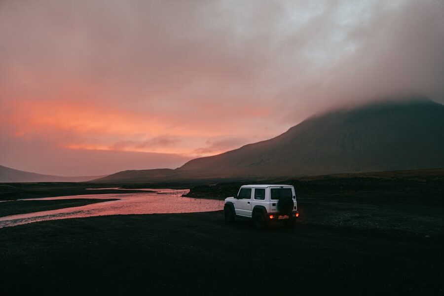
There’s a rhythm to a Golden Circle day that most visitors don’t know about until they’re standing in front of Strokkur for the third time. You watch the pool settle. The water goes flat. A bluish dome starts to form, about as wide as a paddling pool, and two seconds later it blows twenty metres into the air with a whump you can feel in your chest. Ten minutes. Another eight. Maybe fifteen if the geyser’s in a mood. By the time you’ve walked back to the coach, you’ve seen Iceland’s best magic trick three or four times and the whole thing is free.
That’s the Golden Circle in a paragraph. Þingvellir, Geysir, Gullfoss. You loop it in a day from Reykjavik, you pay a parking fee, and nobody charges you for the geology. Add a glacier hike onto the back of it and you’ve done the two things Iceland is actually famous for, fire and ice, in something like twelve hours. I’ve done it with visitors more times than I can count. Here’s how it really works, which operators I’d book, what each stop is worth, and where it’s worth paying extra.
In This Article
- What the Golden Circle actually is
- Þingvellir, where the plates pull apart
- The Alþingi, a parliament in a rift valley
- Silfra, snorkelling between the plates
- Öxarárfoss and the rest of the park
- The Geysir geothermal area, what Strokkur actually does
- How Strokkur works, the five-second rhythm
- Around the area, Blesi, the Geysir Center, and the café
- Gullfoss, and the woman who saved it
- Sigríður Tómasdóttir’s campaign
- Gullfoss in summer vs winter
- The classic Golden Circle day from Reykjavik
- Self-drive vs guided, when each is worth it
- Glacier hikes, which one, and why
- Sólheimajökull, the easy one
- Vatnajökull and ice caves, the blue-cathedral tour
- Langjökull, snowmobiling and the ice tunnel
- Jökulsárlón and Diamond Beach
- Snæfellsjökull, the novel glacier
- Multi-day options, fitting it all in
- Two-day Golden Circle + South Coast glacier hike
- Three-day Golden Circle + South Coast + Jökulsárlón
- Four-day loop with ice cave (winter)
- When to go, season by season
- Summer (June to August)
- Winter (November to March)
- Shoulder (May, late September, October)
- Safety, what you actually need to know
- Picking an operator, how I’d decide
- What to expect on a typical day
- What I’d skip
- Booking timelines and a few final notes
What the Golden Circle actually is
The Golden Circle isn’t a road. It’s a loop of three sights that happen to sit on a rough triangle between Reykjavik and the inland plateau, Þingvellir (Thingvellir) National Park to the west, the Geysir geothermal area in the middle, and Gullfoss waterfall at the eastern corner. The whole loop is about 230 kilometres, which is nothing by Icelandic standards, and you can do it in a day with time to spare. Most people who visit Iceland for the first time do exactly that.
The name is tourist-board branding from the 1930s, not an old Icelandic tradition. Don’t let anyone tell you the Vikings called it the Golden Circle. “Gullfoss” means “Golden Falls” and the whole loop got named after the waterfall, that’s the extent of it. What the loop does do well is pack Iceland’s three best geological stories into one tidy sightseeing day: a continental rift, an active geyser, and a proper waterfall. Add a glacier hike or an ice cave from the South Coast and you’ve covered most of what people come to Iceland for.
A few practical notes before we go anywhere. The loop is open year-round. Route 36, Route 365, Route 37, and Route 35 link the three sights and all are paved. In summer you can leave Reykjavik at 9 a.m. and be back by 6 with a leisurely lunch at Friðheimar. In winter the same day gets tighter because daylight is four hours, wind can close Route 35 above Selfoss, and your coach driver may tell you we’re doing things in reverse order because the forecast just changed. Þetta reddast, it’ll work out, but build slack in. That’s as true of the Golden Circle as it is of anything else in Iceland.
Þingvellir, where the plates pull apart
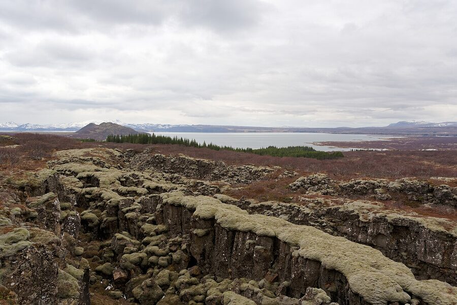
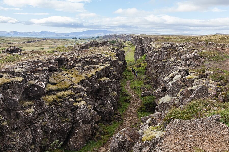
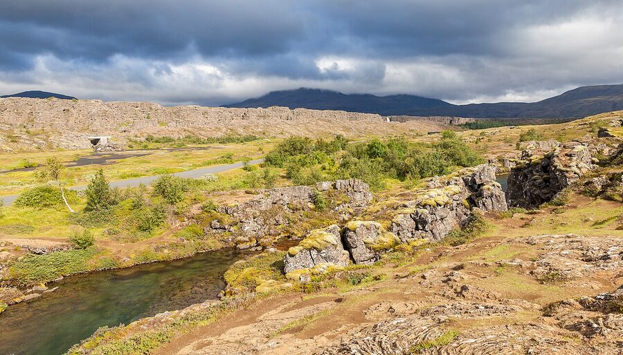
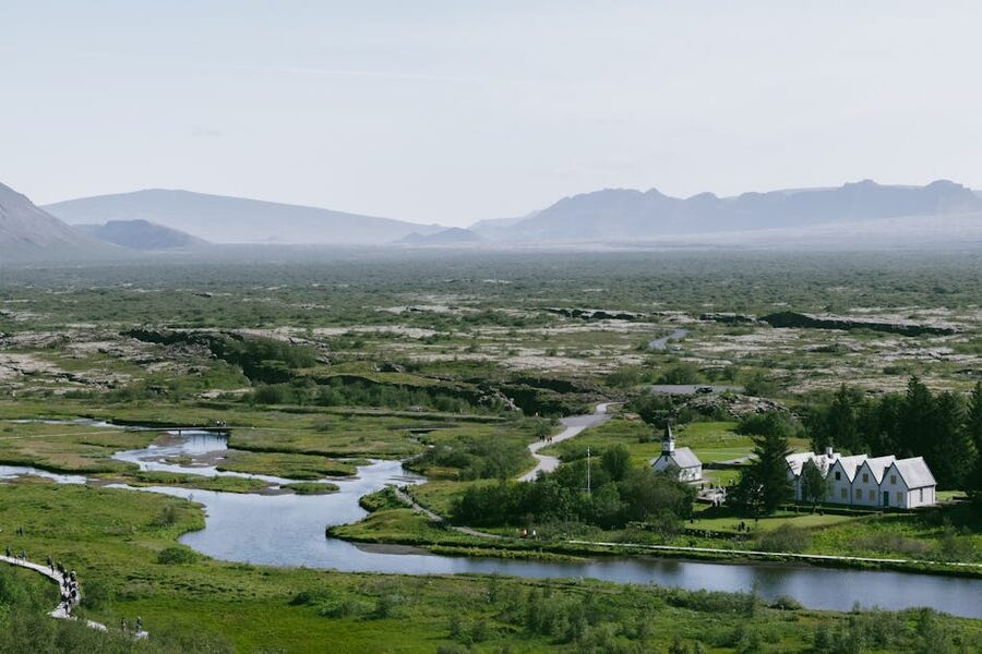
If you only stop at one place on the Golden Circle, make it this one. Þingvellir (pronounced thing-vet-lir) is a UNESCO World Heritage Site and it earns both sides of that listing, the cultural and the geological, which is unusual. Most places are famous for one or the other. Þingvellir is where Iceland stops being a country with scenery and starts being a country with a story.
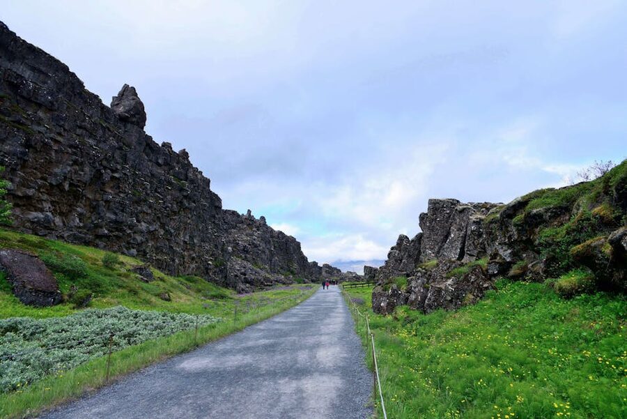
The rift valley you’re standing in is the crest of the Mid-Atlantic Ridge, the seam between the North American and Eurasian tectonic plates. They pull apart at an average of 2.5 centimetres a year, which is hand’s-width over a human lifetime. The Almannagjá (Everyman’s Gorge) canyon on the western side of the park is the edge of the North American plate, a sheer basalt wall that goes on for several kilometres. You can walk down it. Most people do; it’s the signature photograph of the park. The path drops through the canyon and lands you on a flat strip of lava that held the longest-running parliament in the world.
The Alþingi, a parliament in a rift valley
In the summer of the year 930, chieftains from across Iceland gathered on this flat strip of volcanic rock and founded the Alþingi, the parliament of the new Icelandic Commonwealth. Everyone who mattered was there. The longest journey was seventeen days on horseback from the east fjords, over glacier rivers and mountain passes. They set up turf-walled búðir (booths) covered in homespun cloth and camped for two weeks. Merchants sold goods, sword-sharpeners sharpened swords, farmhands looked for work, young people met people they’d marry. And in the middle of all that, on an outcrop called the Lögberg, the Lawspeaker recited the entire body of Icelandic law from memory for three summers in a row. No writing, no notes. Just a man and the laws.
The Alþingi kept meeting at Þingvellir until 1798, 868 years. It moved to Reykjavik in the 19th century and still meets there today. If someone tells you Iceland has the oldest parliament in the world, this is what they mean. Stand on the flat strip below the Lögberg flagpole and imagine a couple of thousand people camped around you. That’s where the Icelandic language was hammered out, where the sagas were first told out loud, where the country converted to Christianity in the year 1000 in a single political decision to keep peace. The flag you see is where it all happened.
Silfra, snorkelling between the plates
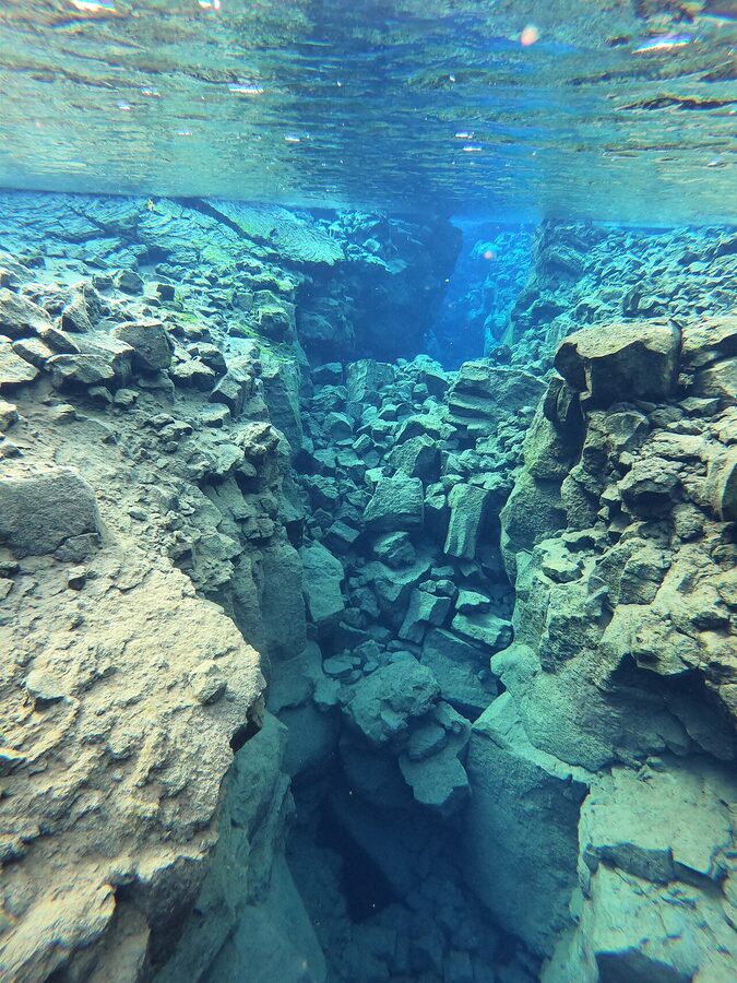
The other thing Þingvellir is known for is Silfra, a fissure full of glacial meltwater so clear you can see 100 metres through it. You snorkel between two continental plates; the walls of the fissure on either side of you are the North American plate and the Eurasian plate. Tours run year-round with dry suits provided. The water is 2°C but the suit keeps you dry from the neck down and you only spend 30–40 minutes in it. Cost is around 22,000–28,000 ISK for a snorkel, 43,000–55,000 ISK for a dive (diving requires dry-suit certification).
Operators I trust: Arctic Adventures, DIVE.IS, and Troll Expeditions. All three have been running Silfra for years, have their own gear, and know the conditions. Book the snorkel rather than the dive if you’ve never done a dry-suit dive before, the snorkel gives you the same view without a course fee. Tours include pickup from Reykjavik or a meeting point at Þingvellir. Water visibility is the same every day of the year; weather above the surface is the variable.
A practical warning: Silfra will be the coldest your face has ever been. Takes about ten seconds to stop flinching. After that you forget because the view is underwater, downwards, into blue nothing, and you’re floating between two continents. It’s the single best 30 minutes you can buy in Iceland.
Öxarárfoss and the rest of the park
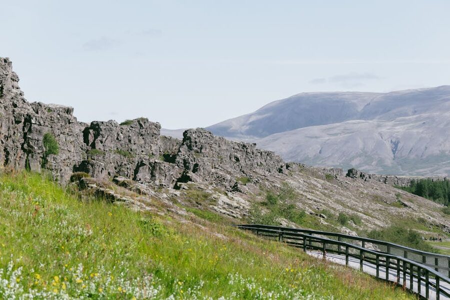
Past the Lögberg, a small river called the Öxará cuts in from the north and drops over the canyon wall in a 20-metre waterfall called Öxarárfoss. It’s modest by Icelandic standards but sits in a striking spot, with the black basalt of Almannagjá framing it. Worth the short walk. In winter it partially freezes and looks like a sheet of glass.
The whole park takes two hours if you walk it properly. Most Golden Circle coaches give you 45 minutes, which is enough for the Almannagjá path, the Lögberg, and a quick look at Öxarárfoss, but you miss the Flosagjá fissure walk and the lakeside at Þingvallavatn. If you self-drive, plan for three hours. Parking is 750 ISK at the P1 or P2 lots. The visitor centre is at Hakið, at the top of the canyon, with the best panoramic view in the park, don’t skip it. More on the park at thingvellir.is.
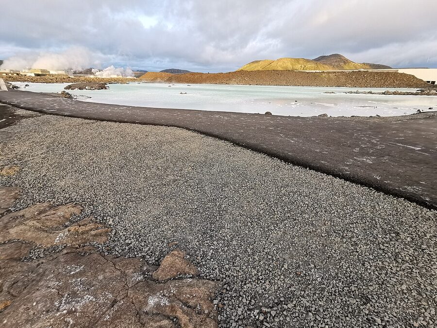
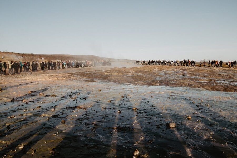
The Geysir geothermal area, what Strokkur actually does
60 kilometres east of Þingvellir, across a basalt plain and past the farming town of Laugarvatn, you reach Haukadalur, a small geothermal valley with two geysers, a scattering of mud pools, fumaroles, and hot springs, and a car park with a gift shop across the road. Most visitors know it as “Geysir.” The name is misleading.
The original Geysir, written with a capital G, is the giant in the corner, and it’s largely dormant. It gave the word “geyser” to every language on earth but hasn’t erupted reliably since the early 20th century, when an earthquake blocked its conduit. Before that, at peak, it could throw water 70 metres in the air. Now it mostly just steams. You’ll walk right past it and probably not notice. The giant pool with the light blue-green tint at the bottom of the path is Geysir itself.
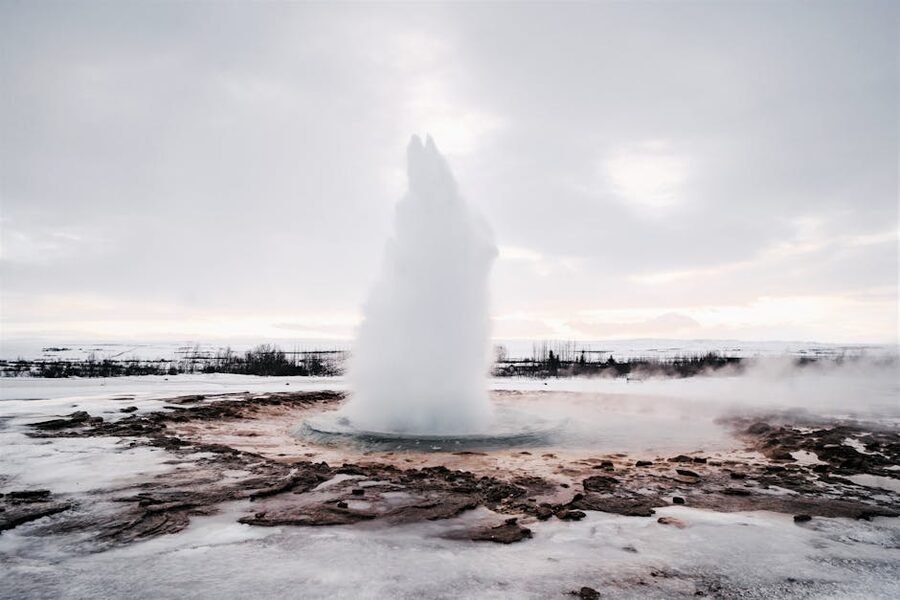
What everyone comes to see is Strokkur, Geysir’s smaller neighbour, 50 metres away. Strokkur means “churn” in Icelandic, which describes both the sound it makes and what the water does in the basin before it blows.
How Strokkur works, the five-second rhythm
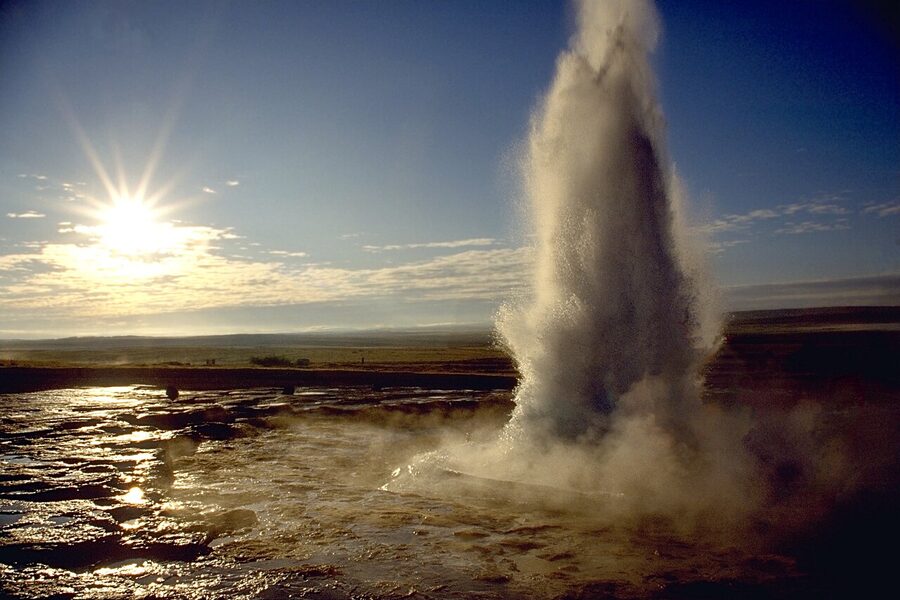
Strokkur erupts every 4 to 10 minutes on average. Sometimes every 6, sometimes 12, occasionally only once in 15. The column typically reaches 15–20 metres but can punch up to 40 on a good one. It’s been erupting reliably since 1963, when locals cleaned out its blocked conduit.
The geology underneath is worth understanding because it changes what you’re watching. The heat source is a magma chamber not far below the surface, Iceland sits on the Mid-Atlantic Ridge, so magma is close to the surface almost everywhere. Groundwater from Langjökull glacier, 50 km north, seeps underground, gets heated by the magma, and enters a silica-lined conduit under Strokkur. Down there, the water superheats to something like 120°C because it’s under pressure. When a pocket of superheated water reaches a critical point, it flashes to steam, and since steam takes up about 1,600 times more space than water, it shoots everything above it straight up. This is called a phreatic eruption and it’s the same mechanism in every active geyser on earth.
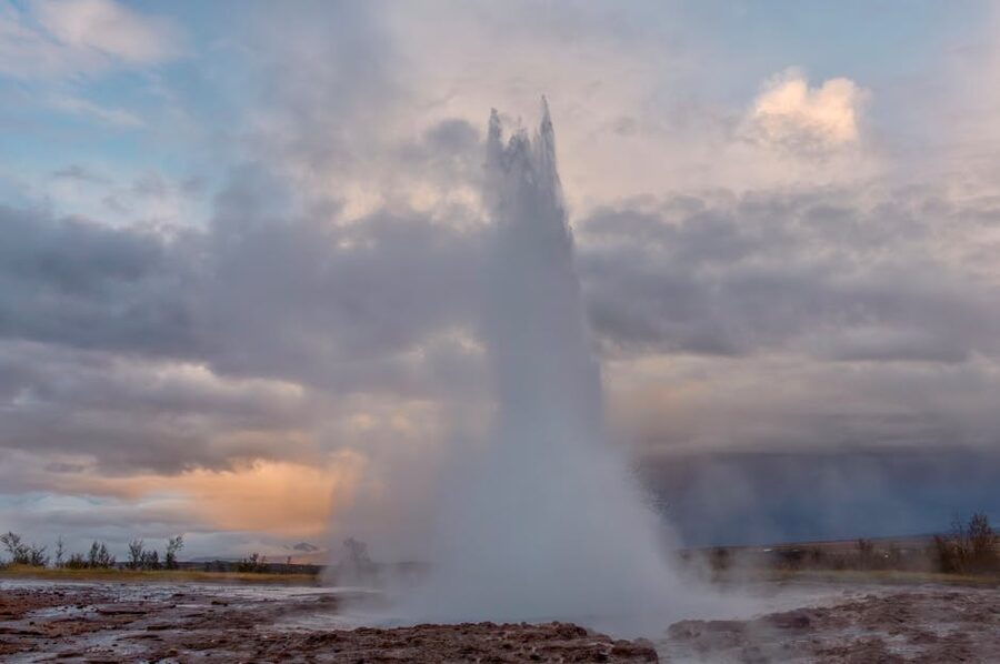
Here’s the thing nobody tells you on the coach: you can see the eruption coming. About 2–3 seconds before Strokkur blows, the pool goes dead calm. The surface flattens. Then a bluish, almost hemispherical dome rises in the middle, the same volume of water bulging up as superheated steam pushes it from below. For a photographer, that’s the shot. If you’re filming, start rolling the moment the water stops swirling; the dome forms, holds for about one second, then vanishes into a column of boiling water twenty metres tall. Five seconds, start to finish. Ten if you count the collapse.
Most people hang around for three or four eruptions. Some try for a dozen. I’d say four is plenty, you’ll have the rhythm by then, you’ll know when to put the camera down and just watch, and your feet will be cold. Allow 45–60 minutes at the geyser site, plus 15 more if you wander up to the unnamed smaller geyser Smiður and the boiling mud pools further up the slope.
Around the area, Blesi, the Geysir Center, and the café
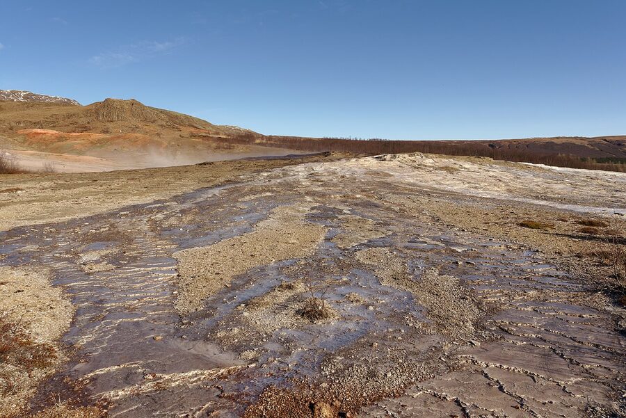
Ten metres past Strokkur are three hot pools including Blesi, which is split into two basins, one clear and 96°C, one a milky turquoise because of silica precipitate. Further up the slope is a fumarole field where sulphur has painted the ground yellow. None of this is fenced off in any elaborate way; there are chains and signs and you follow the path, and the path is good. Stay on it. The silica crust off-path is thin and sometimes covers a 90°C pool.
Across the road, the Geysir Center has a cafeteria with a buffet (around 4,500 ISK), a restaurant, a gift shop that’s priced for tour coaches, and public toilets (inside the Center, free if you buy something, otherwise 200 ISK at a turnstile). Hotel Geysir is in the same complex and is a comfortable option if you want to wake up at the geyser and photograph it in morning light; rooms are around 35,000–45,000 ISK. Parking at the geyser is 1,000 ISK per car per day.
Entry to the geyser field itself is free. The only costs are parking and whatever you buy at the Center. Expect 1.5 hours for the whole stop including a coffee.
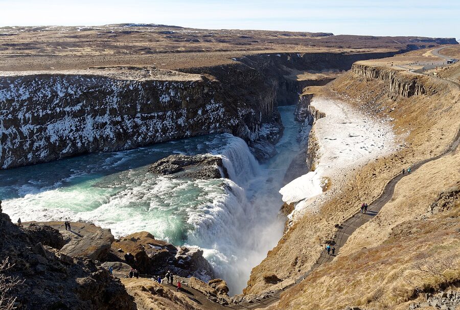
Gullfoss, and the woman who saved it
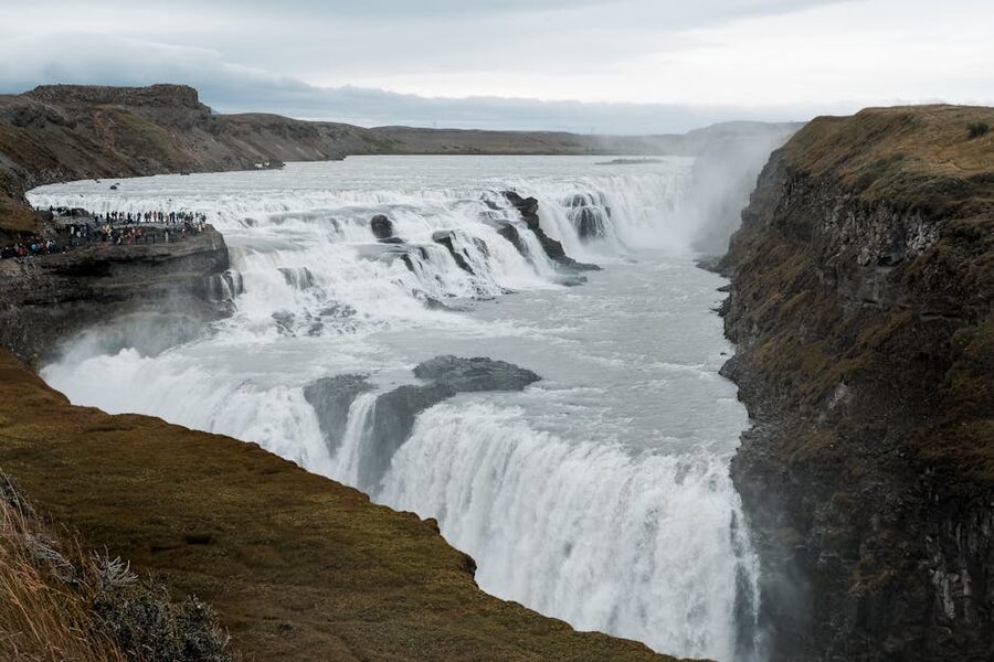
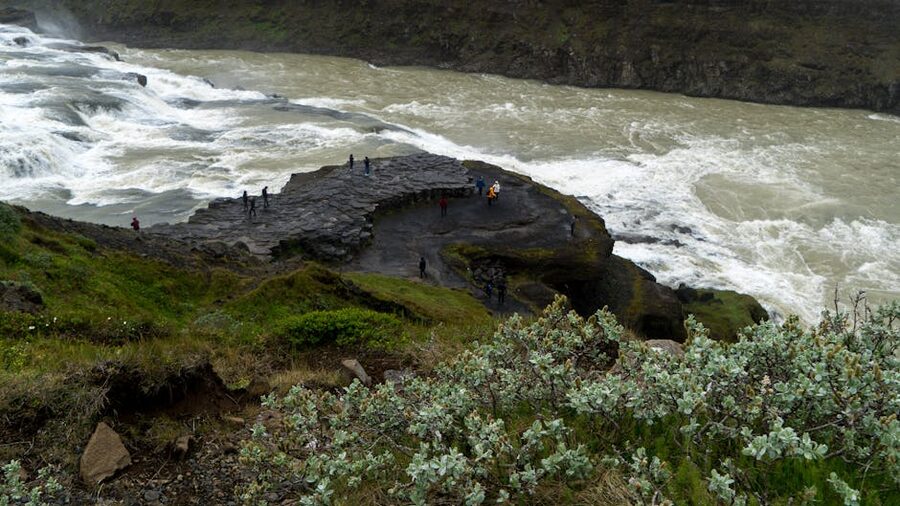
10 kilometres further up Route 35, past a road sign warning about wind gusts, you reach Gullfoss. The parking is vast because this is the most-visited waterfall in Iceland, and the viewpoints are laid out on two levels, the upper deck gives you the panorama, the lower path gets you close enough to feel the spray.
Gullfoss means “golden falls,” a reference to the brown, glacier-silt colour the water takes on in summer afternoon light. The Hvítá river flows south off Langjökull, takes a sharp right, and drops 32 metres in two stages, an 11-metre upper fall and a 21-metre lower fall, into a crevice that cuts perpendicular to the river’s course. Average flow in summer is 140 cubic metres per second, roughly five heavy lorries of water per second. In flood, it’s been recorded at 2,000 cubic metres per second. You feel that number when you stand at the lower viewpoint.
Sigríður Tómasdóttir’s campaign
There’s a bronze plaque above the falls with the profile of a woman named Sigríður Tómasdóttir. Most people walk past it. They shouldn’t.
In the early 1900s, foreign investors were trying to build a hydroelectric dam at Gullfoss. The land belonged to a farmer named Tómas Tómasson, Sigríður’s father. Tómas had signed a contract that let a British company develop the falls for electricity. Sigríður didn’t agree. She’d walked to the falls since she was a child, cut the first paths down to the gorge, and didn’t want to see it destroyed for a power station. She walked to Reykjavik, 120 kilometres on foot, multiple times, to argue the case in court. She reportedly threatened to throw herself into the falls if the dam went ahead. The contract eventually lapsed on a technicality, the investors failed to pay, and the land went back to the family. In 1940 Sigríður’s legal advisor, a young man named Sveinn Björnsson, who later became Iceland’s first president, had the Icelandic government buy Gullfoss outright. It’s been a protected site since 1979.
Without Sigríður there would be a dam here. The plaque is understated, a profile, her name, her dates. In Iceland we don’t do elaborate monuments for the most part. She’s the reason you’re looking at a waterfall and not a concrete spillway, and that’s worth a minute of your time.
Gullfoss in summer vs winter
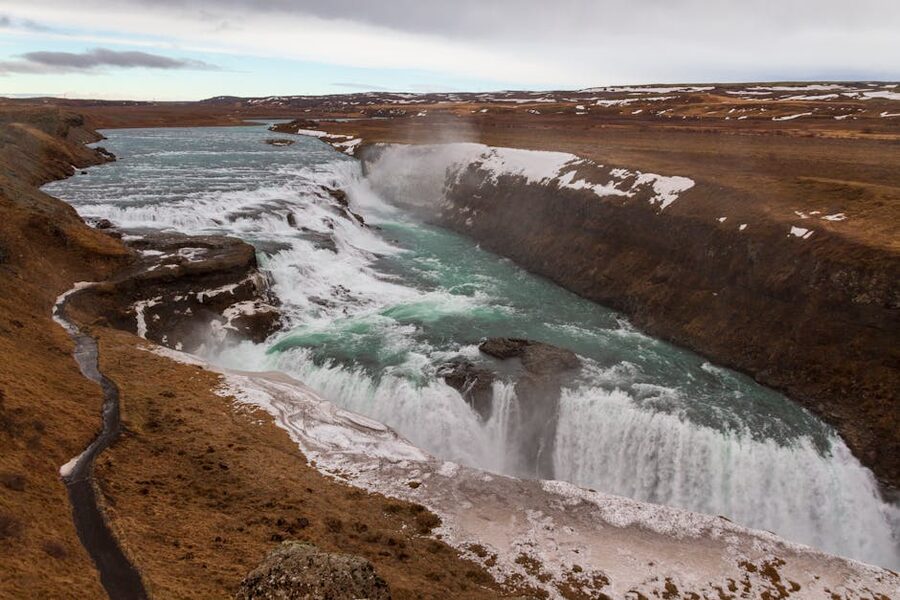
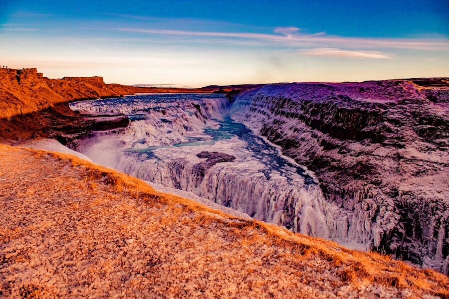
Summer gives you the volume and the summer evening light, which is still on the water at 10 p.m. in July. Winter gives you the ice, with the canyon walls frozen into curtains and the spray building up a glacial crust along the path. Both are worth seeing, but they’re different photographs.
The lower viewing path is sometimes closed in winter when ice makes it dangerous, a sign at the top of the stairs tells you. Don’t go around the sign. A fall into the gorge is fatal and has happened. The upper viewpoint stays open year-round. Allow 45 minutes to an hour at Gullfoss; a café at the parking area does a decent lamb soup for 2,500 ISK if you’re cold.
The classic Golden Circle day from Reykjavik
A full Golden Circle day, by coach or self-drive, usually runs 8 to 10 hours round-trip from Reykjavik. Here’s what a typical itinerary looks like:
- 09:00, depart Reykjavik (BSÍ terminal or hotel pickup)
- 10:00–11:15, Þingvellir National Park
- 12:00–13:30, Geysir area + lunch at the cafeteria or across at Friðheimar tomato farm
- 14:00–15:00, Gullfoss
- 15:30–16:30, Secret Lagoon (a natural hot spring at Flúðir) or Kerið crater
- 18:00, back in Reykjavik
Operators I’d book for a classic coach day tour:
- Reykjavik Excursions, the biggest operator, runs the Golden Circle Classic daily in both summer and winter for around 10,900 ISK. Modern coaches, pickup from BSÍ or select hotels, English-speaking guide. Stops at the three main sights and sometimes adds Faxi waterfall or Skálholt church. Solid, predictable, not exciting. Book at re.is.
- Gray Line Iceland, very similar product, around 10,500 ISK, slightly smaller coaches. Pickup from a different set of hotels. I don’t prefer one over the other, it depends which company’s pickup point is nearer your accommodation.
- Arctic Adventures, runs a minibus Golden Circle (max 19 people) for around 13,000 ISK. Better if you prefer smaller groups. Also their Silfra snorkel add-on pairs naturally with Þingvellir, you can book a Golden Circle + Silfra combo for around 33,000 ISK.
- Troll Expeditions, smaller operator, often uses super-jeeps or minibuses, tends to do off-piste stops other coaches skip (the Brúarfoss hike, Kerið crater from the back path). 15,000–18,000 ISK for a day tour. Good if you want a slightly less-packaged feel.
For bigger aggregator marketplaces, GetYourGuide and Viator both list every operator above plus a few smaller outfits; prices tend to match the operator’s own site. I’d book direct with the operator where possible.
Self-drive vs guided, when each is worth it
The short version: if you’re two adults or more, can drive in foreign weather, and have a rental car, self-driving the Golden Circle in summer is easy. In winter it’s still doable with a 4WD and some sense. A coach makes more sense for solo travellers, anyone nervous about icy roads, or families who don’t want a parent locked to a steering wheel for 8 hours.
Self-drive advantages:
- You decide how long to spend at each stop. Want 90 minutes at Gullfoss instead of 30? Fine.
- You can add Kerið crater, the Secret Lagoon at Flúðir, Friðheimar (tomato farm, excellent Bloody Marys), and the geothermal bakery at Laugarvatn Fontana, none of which most coaches hit.
- Cheaper for two people. Two Golden Circle coach tickets are 22,000 ISK. A small rental car for a day is around 10,000 ISK plus fuel.
Guided advantages:
- Somebody else drives. You can stare out the window.
- Guides know where the nice angles are and will tell you things you didn’t know about the Commonwealth.
- Winter. Don’t self-drive winter unless you’re comfortable with ice and know what to do if a gust pushes you sideways.
If you’re already planning a multi-day trip, build the Golden Circle into day one or two and then keep the rental for the South Coast. That’s how most self-drive packages are structured. For a custom route with a local driver-guide, see our custom tour guide.
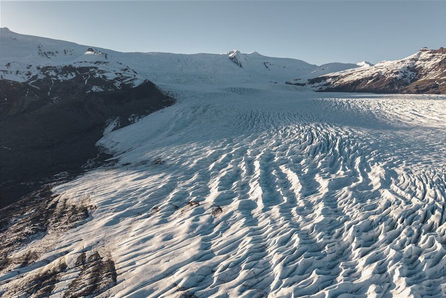
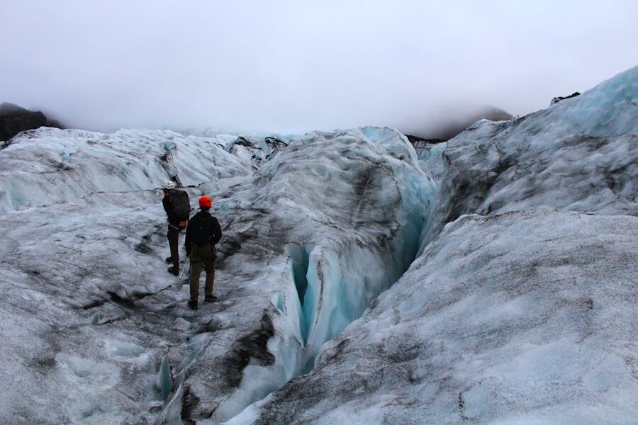
Glacier hikes, which one, and why
Iceland’s got roughly 11% of its surface under glacier ice, four really big ice caps (Vatnajökull, Langjökull, Hofsjökull, Mýrdalsjökull) plus a handful of smaller ones. Not all of them are walkable without crevasse rescue gear and a week of training. A few are. Here’s the practical ranking for a visitor doing a day or two-day combo from Reykjavik.
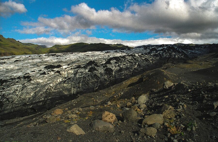
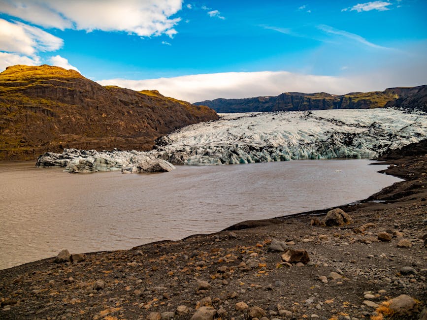
Sólheimajökull, the easy one
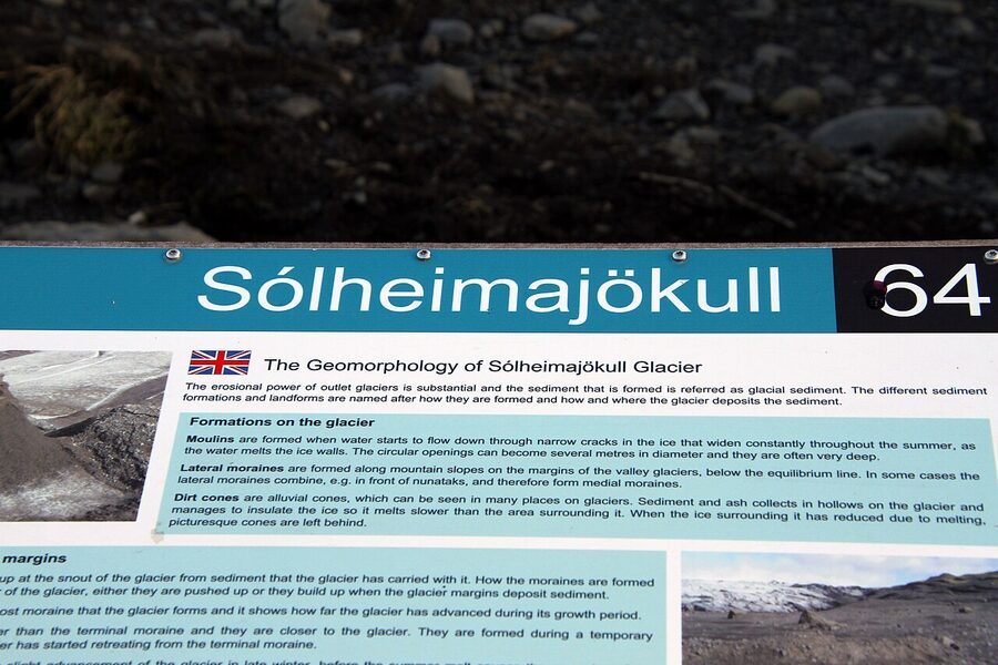
Sólheimajökull is an outlet tongue of Mýrdalsjökull, it comes off the big ice cap, flows down a valley, and ends at a lagoon that didn’t exist until 2007. You can drive there from Reykjavik in 2.5 hours on Route 1. Park at Sólheimajökulsvegur, walk 800 metres on a gravel path to the ice edge, and then you’re on the glacier. No helicopter, no jeep transfer, no slog.
This is the glacier most Golden Circle + Glacier day tours hike, and it’s the one I’d pick for a first-timer. The standard 2-hour hike goes up the tongue, past a collapsed ice cave, through a ridged blue-ice section, and loops back. Guides carry ice axes but you mostly don’t need them. You will use crampons, which fit over your boots and take a minute to learn. Walk purposefully, ice is better than rock for grip.
What makes Sólheimajökull interesting to look at isn’t the blue ice, though there is some, it’s the black ash. Every Katla eruption in the last thousand years has laid a layer on the glacier, and as the ice melts you see the layers exposed as ridges and peaks. A dark glacier is not a dirty one; it’s a geological record.
Cost: 12,000–18,000 ISK for the 2-hour hike from the car park (all gear included). 25,000–35,000 ISK for a full day from Reykjavik that includes the drive, the hike, plus Seljalandsfoss and Skógafoss waterfalls. Operators:
- Arctic Adventures, the yellow-school-bus operator you see in the Sólheimajökull car park. Been running these hikes the longest, excellent guides, solid English. Around 15,000 ISK for the 2-hour hike, 27,000 ISK for the full-day ex-Reykjavik.
- Icelandic Mountain Guides (icelandmountainguides.com / mountainguides.is), the mountaineering outfit. Their Easy Glacier Discovery is 2.5 hours on Sólheimajökull for around 13,500 ISK. Their Glacier Walk full-day ex-Reykjavik is around 28,000 ISK.
- Troll Expeditions, smaller groups, slightly pricier (around 16,500 ISK for the 2-hour hike), very personal. I’d pick them if you want to feel like you’re not with a coach.
- Reykjavik Excursions, runs a Golden Circle and Glacier Hike as a single long day for around 29,000–34,000 ISK. Less time at each stop but a decent all-in-one if you’ve only got a day.
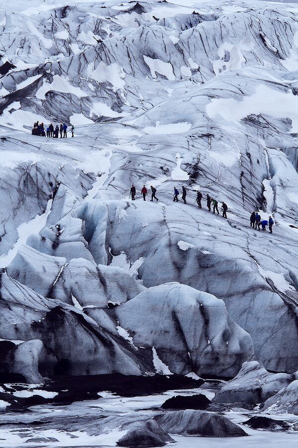
Vatnajökull and ice caves, the blue-cathedral tour
Vatnajökull is Europe’s largest glacier by volume, a single ice cap about the size of Corsica, with roughly 30 outlet glaciers spilling off the edges. You don’t hike Vatnajökull itself in a day trip; you hike one of its outlet tongues, usually Svínafellsjökull or Falljökull near Skaftafell, about 4.5 hours’ drive from Reykjavik.
What Vatnajökull is actually known for is the ice caves. From about early November to late March, the summer meltwater drains out of the glacier and the tunnels it carved through the ice become walkable. These are natural, not tunnelled, not artificially lit, and the ice turns blue where it’s oldest and most compressed. No two caves look the same, and nothing in a cave looks the same week to week; warm weather closes one, cold weather opens another.
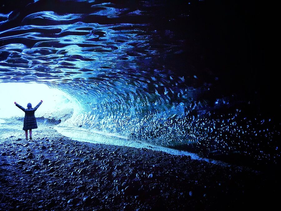
Cost: 20,000–30,000 ISK for a 3-hour ice cave tour from Jökulsárlón. Add around 20,000 ISK for a half-day from Reykjavik if you want the drive included (it’s long, most people stay in Vík or Höfn for a night and do the cave tour from there). Operators I trust:
- Local Guide of Vatnajökull, small outfit based at Jökulsárlón, excellent reputation.
- Glacier Adventure (glacieradventure.is), Höfn-based, focused on ice caves and glacier hikes on the east side of Vatnajökull.
- Arctic Adventures and Icelandic Mountain Guides both run multi-day tours out of Reykjavik that pair Golden Circle with Vatnajökull ice caves; budget 3 days and 85,000–120,000 ISK depending on accommodation level.
Safety note: never walk into a Vatnajökull cave unguided. The ice shifts, the roof can collapse, and meltwater streams through some caves in ways that catch you off guard. The guides spend their off-season in ice-rescue training. Book the tour.
For the official park’s tour-booking page and maps, see Vatnajökull National Park. The park covers 14,000 km², second largest in Europe after Yugyd Va in Russia.
Langjökull, snowmobiling and the ice tunnel
Langjökull is Iceland’s second-biggest glacier and the closest one to the Golden Circle, it sits north of Gullfoss. The meltwater under it is what feeds both the Hvítá river and, underground, the water that resurfaces in Þingvellir’s fissures and in Strokkur’s vent. Everything connects, geologically, if you zoom out enough.
Langjökull’s two main activities are snowmobiling and the ice tunnel, and they’re often combined with the Golden Circle in a single day.
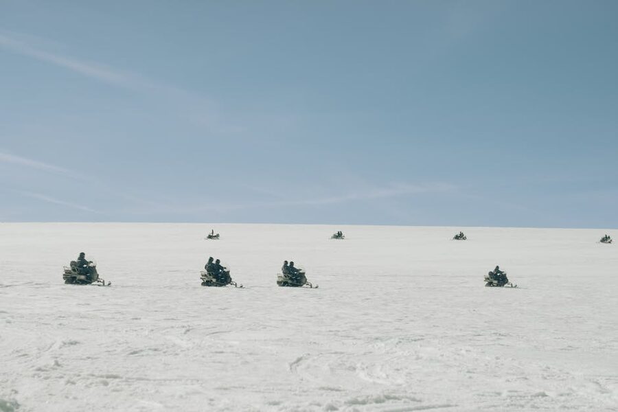
Snowmobiling: Mountaineers of Iceland and Arctic Adventures both run 1-hour snowmobile tours on top of Langjökull, usually as a Golden Circle + Snowmobile combo day out of Reykjavik. You ride as a pair (one driver, one passenger) on a pre-groomed trail. Easy, you don’t need experience. Cost is 32,000–45,000 ISK for the combo day. It’s fun, it gets you onto a proper glacier surface, and the views across to the highlands are excellent on a clear day.
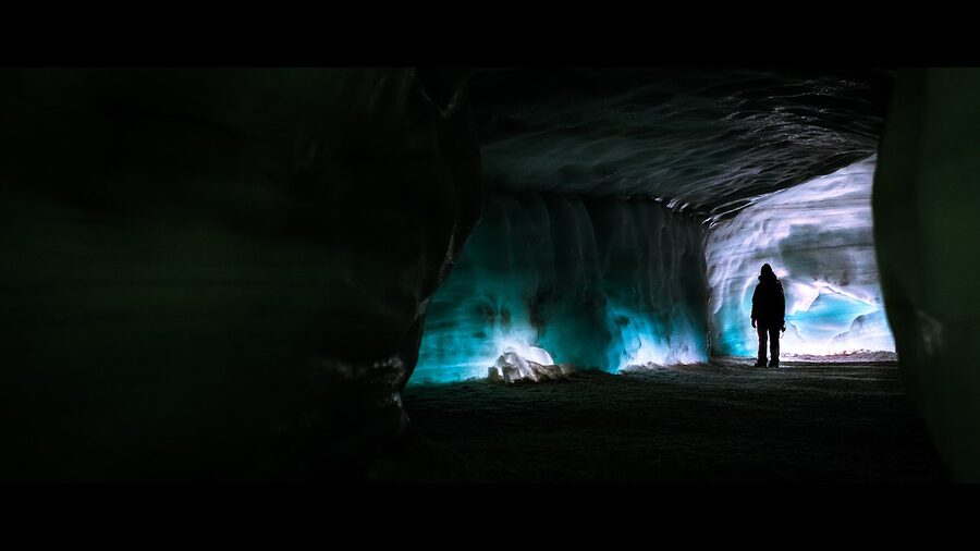
Into the Glacier is the ice tunnel, a network of corridors cut 30 metres into the Langjökull ice cap in 2014. It’s the only artificial ice tunnel in Europe and it’s open year-round because the tunnel is inside the ice, so warm surface weather doesn’t matter. You board a converted 8-wheel snowcat at Klaki base, drive 15 minutes onto the glacier, and spend about an hour walking through the tunnels. They’ve carved chambers, including a small chapel where people get married (about 30 weddings a year).
Cost: around 21,000–25,000 ISK for the tunnel tour itself, or 39,000–45,000 ISK bundled with the Golden Circle in a long day from Reykjavik. Operator is Into the Glacier (intotheglacier.is). This one I’d book if you’re visiting outside ice-cave season (April–October), because ice caves are closed and the tunnel is the only way to be inside a glacier.
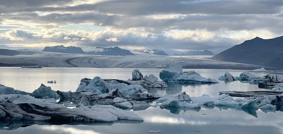
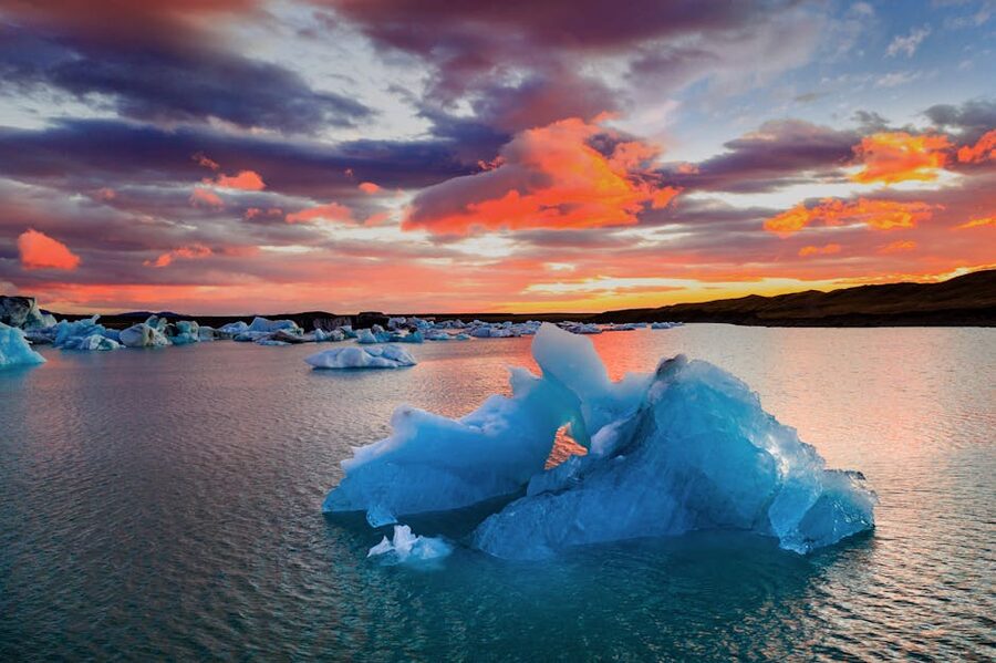
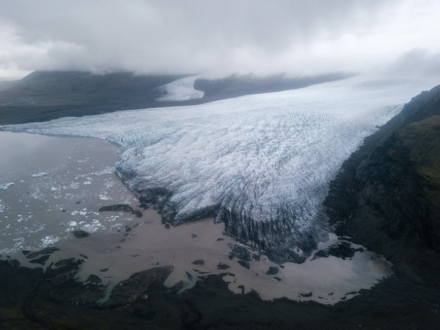
Jökulsárlón and Diamond Beach
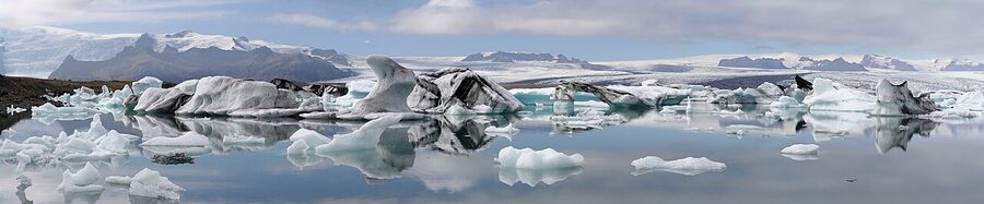
Jökulsárlón isn’t a glacier hike, it’s a lagoon in front of one. The Breiðamerkurjökull outlet glacier calves icebergs directly into the lagoon, and they float through it to the sea. In 1920 none of this existed. The glacier terminated at the coast. Since then, as the ice retreated inland, a basin opened up, the sea flooded in, and now you have a tidal lagoon full of icebergs and the occasional seal.
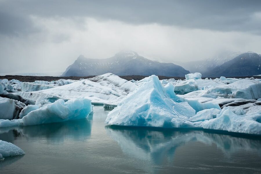
You can walk around the shore for free. There’s a car park, a café, and two boat operators (amphibious vehicle or zodiac) that take you out among the icebergs for about 9,500 ISK / 60 minutes. The zodiac is the better one if you’re physically able, you get closer to the ice and can reach the back of the lagoon. The amphibious vehicle is fine, slightly more sedate, easier for older visitors.
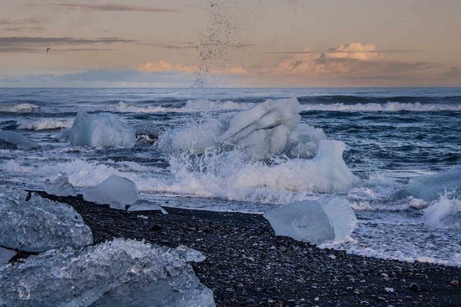
Diamond Beach is the black-sand strip of coast right across Route 1 from the lagoon. Icebergs that drift out of the lagoon get pushed back up the beach by the surf and strand on the sand, where they melt slowly in the sun. On a sunny afternoon the beach is studded with hundreds of icebergs from the size of a suitcase to the size of a car. Nothing else in Iceland looks like it. Worth five minutes even if you’re racing a sunset to Höfn.
Snæfellsjökull, the novel glacier
Snæfellsjökull is the glacier on the tip of the Snæfellsnes peninsula in west Iceland. It’s a stratovolcano with an ice cap on top, about 1,446 metres at the summit, and visible from Reykjavik on a clear day. Jules Verne’s Journey to the Center of the Earth starts here, the characters climb down into the crater. That’s why the glacier has a literary afterlife that Langjökull doesn’t.
Summiting Snæfellsjökull is a 7–9 hour day tour from Arnarstapi or Ólafsvík, usually with Summit Guides or Icelandic Mountain Guides, for around 45,000–55,000 ISK. It’s more physical than Sólheimajökull, properly mountaineering-adjacent, with harness and rope, but doable by anyone reasonably fit. The view from the summit takes in most of west Iceland. If you’re driving the peninsula for a day you might not want to commit to this; if you’ve got a spare day and the weather’s clear, it’s the most dramatic glacier summit within driving distance of Reykjavik.
For a looser itinerary around the peninsula (not summiting, just exploring), Snæfellsnes is worth a full day on its own, Kirkjufell, Djúpalónssandur black pebble beach, the crater at Saxhóll, and Arnarstapi sea cliffs. Not strictly glacier tourism but the glacier is always on your horizon.
Multi-day options, fitting it all in
A day gets you the Golden Circle. If you want the Golden Circle plus a proper glacier hike, you need two. If you want ice caves too, you need three or four. Here’s how I’d structure each:
Two-day Golden Circle + South Coast glacier hike
Day 1: Golden Circle classic (Þingvellir, Geysir, Gullfoss), overnight in Selfoss or Vík. Day 2: South Coast drive to Seljalandsfoss → Skógafoss → Sólheimajökull glacier hike (2 hours on the ice) → Reynisfjara black-sand beach → back to Reykjavik. Around 50,000–70,000 ISK per person with guided tours, less if you self-drive. Good compromise if you’re on a short trip and want the two classic experiences.
Reykjavik Excursions, Arctic Adventures, and Icelandic Mountain Guides all offer this as a packaged two-day tour with accommodation in Vík included, for around 75,000–110,000 ISK per person.
Three-day Golden Circle + South Coast + Jökulsárlón
Day 1 as above. Day 2: South Coast to Vík. Day 3: early start, drive to Jökulsárlón (2.5 hours from Vík), walk the lagoon, cross to Diamond Beach, and either turn around and drive back to Reykjavik (long day) or overnight in Höfn. For most people the 3-day is worth it because Jökulsárlón is the best single sight on the south coast and you’d kick yourself for skipping it. In winter, add an ice cave tour from Jökulsárlón, that’s when the 3-day becomes a 4-day.
Cost: budget 100,000–140,000 ISK per person for a 3-day guided with hotels; 50,000–75,000 ISK self-drive plus your car.
Four-day loop with ice cave (winter)
Day 1 Golden Circle, Day 2 South Coast to Vík, Day 3 Jökulsárlón + ice cave tour (stay Höfn or return to Vík), Day 4 back to Reykjavik via the Eyjafjallajökull area. The ice cave is what makes this work, without it you’re padding. Budget 150,000–200,000 ISK per person guided. November to March only.
For more on how to build a custom itinerary, including flying in a glacier seaplane or adding a private driver-guide, see our custom tour planning guide. And if you’re doing this in December, read our Christmas Iceland guide for what to expect from the weather and the dark.
When to go, season by season
Summer (June to August)
Long daylight, full sun at midnight from around the 15th of June, means you can do the Golden Circle at 10 p.m. and still get photographs. Glacier hikes are easier because the weather’s more predictable. Ice caves are closed, the summer meltwater is too dangerous, and the natural caves fill with water and collapse. This is the high season in every sense: the coaches are packed, the parking at Gullfoss takes 15 minutes to find a spot, and accommodation on the South Coast books out six months ahead.
If you want the Golden Circle plus a glacier hike, summer’s the easiest time. If you want an ice cave, you can’t have one, you’ll need to come back in November.
Winter (November to March)
Winter is when the ice caves open. It’s also when you can combine the Golden Circle with a chance of the aurora, if the sky is clear and the KP index is high enough. Always check vedur.is around lunchtime for the evening forecast; the aurora is not a guaranteed feature and nobody should promise you one.
The downsides of winter: daylight is four hours in December, Route 35 between Gullfoss and the coast can close in a storm, and you have more weather risk across the board. On the plus side, coaches aren’t full, the sky around sunset is pink for two hours instead of ten minutes, and Strokkur against a snowfield is a better photograph than Strokkur against brown grass.
Shoulder (May, late September, October)
Arguably the best time, if you’re willing to accept that the ice caves are probably not open and the glacier on Sólheimajökull might be slushier than ideal. Daylight is reasonable (8–12 hours), crowds are way down, prices on accommodation drop 20–30%, and you can still get an aurora night if the sky cooperates. May and September specifically tend to have fewer storms than February. I’d pick mid-September if I were coming for photography.
Safety, what you actually need to know
A few things that really are important, stated plainly:
- Never walk onto a glacier without a guide. Crevasses appear constantly, they can be snow-bridged and invisible, and a fall into one is usually fatal. Operators are cheap compared to a helicopter rescue or a funeral.
- Ice cave conditions change week to week. A cave that was stable on Monday can close on Wednesday. Your tour operator will tell you which cave is open on the day. Don’t book a specific cave, book a tour.
- Route 1 closes. The Icelandic Road and Coastal Administration (road.is) and vedur.is post closures and forecasts. Check before driving. In winter “yellow alert” means caution, “orange” means don’t if you can avoid it, “red” means don’t at all.
- Boiling pools off-path at Geysir. The crust around hot springs is thin. People have been scalded stepping off the path for a photograph. Stay on the gravel. No exceptions.
- Gullfoss viewing paths. The lower path is barrier-free for most of its length. The railings at the edge are low. Icy winter conditions make this genuinely risky. If a sign closes the lower path, the sign is right.
- Layers, boots, waterproofs. “It’s summer, I brought a fleece” is not a plan. The wind and rain at Strokkur can be Scottish on a Tuesday. At Sólheimajökull you want hiking boots, waterproof trousers, a proper shell. Most glacier operators rent gear for around 3,500 ISK if you didn’t bring it.
For official environment and park guidance, see the Environment Agency of Iceland and each park’s own site.
Picking an operator, how I’d decide
There are a few criteria that actually matter when you’re choosing between operators, and a few that don’t.
Matters:
- How long they’ve been running the specific trip. Glacier guiding is a craft. Reykjavik Excursions and Icelandic Mountain Guides have been on Sólheimajökull for decades. I’d pay 10% more to not book a company that started last year.
- Group size. A coach of 45 on a Golden Circle day is a different experience from a minibus of 16. Smaller group, more flexibility, better photographs because you’re not queuing to stand where everyone else is standing.
- Whether pickup is from your hotel or a meeting point. Reykjavik Excursions and Gray Line do hotel pickup; Arctic Adventures sometimes uses BSÍ only. If you’re staying in Grandi or Laugardalur, pickup from BSÍ means an additional bus trip in the morning.
- Recent reviews. Not the star rating, the most recent written reviews. If three people in the last month said the guide was rushed, that’s a pattern.
Doesn’t matter much:
- Brand name. A two-year-old company with good guides is better than a twenty-year-old company with tired guides.
- Price difference of a few thousand ISK. Golden Circle coach tours cluster around 10,000–12,000 ISK; within that range the product is almost identical. Don’t optimise for the last 5%.
- Whether they call themselves “premium.” Premium in Iceland means “coffee included.” It doesn’t mean better guiding.
For Golden Circle classic coach tours, I’d book Reykjavik Excursions for the logistics or Arctic Adventures for the smaller group. For Golden Circle + Sólheimajökull glacier hike, Arctic Adventures or Icelandic Mountain Guides. For Jökulsárlón + ice cave, a small Höfn-based operator like Glacier Adventure. For Into the Glacier, there’s only one operator and they’re competent. For a private bespoke route with a driver-guide, see our custom tours page.
What to expect on a typical day
You’ll get picked up between 8:30 and 9:00 a.m., usually by a small minibus that shuttles you to BSÍ or directly to the day’s coach. Drive to Þingvellir takes about 45 minutes. You’ll get 45–75 minutes at the park, which is enough time to walk the Almannagjá path once, see the Lögberg, and take a breath.
Back in the bus, drive 60 minutes to Haukadalur, usually with a toilet stop at the Geysir Center cafeteria. 45 minutes at Strokkur. You’ll see it erupt three or four times; take a photo of one, watch the next three without the camera. Buy a coffee at the cafeteria.
Drive 10 minutes to Gullfoss. 45 minutes on the viewpoints. The guide will give you a heads-up about Sigríður. Take the upper-to-lower walk at least once.
Lunch is often at Friðheimar, a geothermally-heated tomato greenhouse 15 minutes off the main road, where they serve tomato soup in a greenhouse full of tomato vines. It’s gimmicky but the food is genuinely good (around 3,500 ISK for soup and bread). Some tours skip this; if yours does, Geysir Center’s cafeteria is a fine substitute.
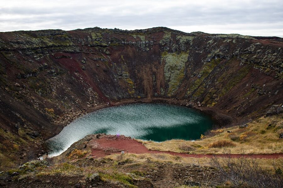
Depending on the tour, you’ll add Kerið crater lake (a collapsed caldera with turquoise water, 5 minutes’ walk around, 400 ISK entry), the Secret Lagoon (a natural hot spring bath at Flúðir, requires an hour plus swim kit), or Skálholt (a historical church site). Back in Reykjavik by 6 or 7 p.m.
For a Golden Circle + glacier combo, the day extends to 10–12 hours, you eat lunch on the coach, and you reach Sólheimajökull around 2 p.m. for a 2-hour hike, back in Reykjavik around 8 p.m.
What I’d skip
A few things that aren’t always worth it, said plainly:
- Paid photography tours of Strokkur. You don’t need a photo guide for a geyser. You need patience and a half-decent camera. Save the money.
- “Golden Circle + Blue Lagoon” combos that try to do both in a day. You end up rushing the Circle and not having time to actually relax at the lagoon. Do them on separate days; the Lagoon’s fine as a one-off after your flight.
- Helicopter glacier landings without a walk. Some operators sell you 15 minutes on a glacier for 80,000 ISK. You get the helicopter ride, which is nice, and a photo, which is nicer still, but you’re not actually on the glacier long enough to feel it. If you want a helicopter, do the 2-hour tour with an actual landing and hike, not the 45-minute scenic-only one.
- The gift shop at the Geysir Center. Everything’s cheaper in Reykjavik.
Booking timelines and a few final notes
Golden Circle coach tours can be booked a few days in advance year-round; even in August you’ll usually find a seat. Glacier hikes on Sólheimajökull need a week’s lead time in summer, more in peak July–August. Ice caves need at least two weeks in December–February. Silfra snorkel runs sell out a week in advance in summer and need 3–4 days in winter. Into the Glacier tunnels are bookable about two weeks out year-round.
If you’re combining three or four of these in a week, it’s easier to book everything through one operator (Reykjavik Excursions and Arctic Adventures both bundle well) than to stitch together four separate booking confirmations. Alternatively, and this is what I’d do, have a local trip planner put the whole thing together, see our custom tours page for operators I rate.
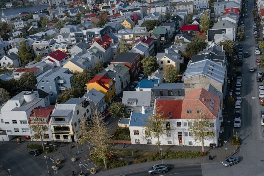
For everything in Reykjavik when you’re not out on the road, where to eat, what to do with a rest day, which pool to swim at, see our Reykjavik guide. And if you’re into day-tripping more broadly, browse the full tour guides category.
That’s glaciers and geysers from someone who’s watched Strokkur erupt more times than I can count. The geology does the same trick every time; the trick is still worth showing up for.