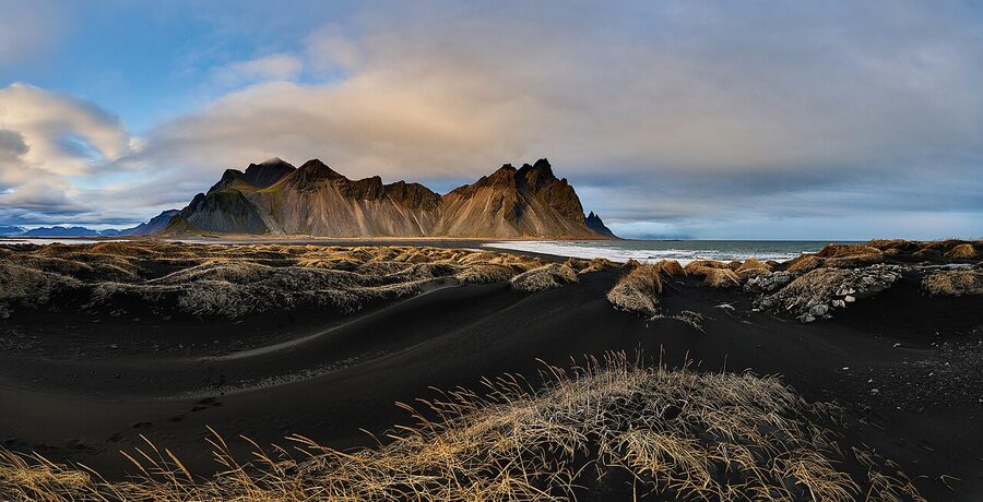
The rock under your feet in Iceland is, geologically speaking, basically wet paint. The oldest exposed bedrock anywhere on the island is around 16 million years old, and the youngest is whatever erupted last week on the Reykjanes peninsula. For comparison, the chunk of granite under London is about 400 million years old. Some Scottish gneiss is 3 billion. Iceland is the toddler of the North Atlantic, and like a toddler it cannot sit still.
I grew up here. I have walked into a magma chamber that emptied 4,000 years ago. I have watched fresh lava set fire to a hillside two hours from my house. I have driven the Ring Road past glaciers that were several hundred metres bigger when my grandmother was young. None of this is normal in most countries. In Iceland it is the weather report. So let me explain, as plainly as I can, why this island looks the way it does, what is making it move, and where you can actually go and see it for yourself.
In This Article
- Two plates, one hotspot, one very young island
- Walking between continents at Þingvellir
- Silfra, snorkelling between two continents
- The Bridge Between Two Continents on Reykjanes
- The volcanoes, what they are and which ones matter
- Hekla, the gateway to hell
- Katla, sleeping under the ice
- Eyjafjallajökull, the one nobody can pronounce
- Bárðarbunga and the Holuhraun fissure, 2014 to 2015
- Grímsvötn, the most active volcano you have not heard of
- Askja, the 1875 caldera
- Krafla and the Mývatn fires, 1975 to 1984
- Laki, 1783, the eruption that changed Europe
- Reykjanes and the new fires, 2021 to now
- Þríhnúkagígur, the volcano you can climb inside
- What the rocks look like and why
- Reynisfjara, the columns at the beach
- Svartifoss, the church-organ waterfall
- Stuðlagil, the canyon discovery
- Aldeyjarfoss, the columns and the curtain
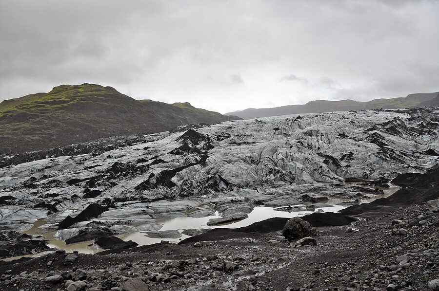
- The glaciers, eleven percent of the country under ice
- Vatnajökull, the big one
- Jökulsárlón, the lagoon at the front
- Sólheimajökull, the easy outlet
- Snæfellsjökull, the cap of the western peninsula
- Okjökull, the glacier that died
- Geothermal Iceland, where the heat actually goes
- Strokkur and the geyser that named them all
- Hverir, the boiling earth
- The hot pots, why every village has one
- Lava fields, pseudocraters, and the alien landscape
- Dimmuborgir, the dark castles
- Hverfjall, the perfect tephra cone
- Landmannalaugar, the rhyolite mountains
- Surtsey, the youngest island in the world
- The basalt-and-moss landscape that trained astronauts
- Climate change and the glaciers, what is actually happening
- How to actually see the geology
- Watching for the next eruption
Two plates, one hotspot, one very young island
Iceland exists for two reasons at the same time, and most other places on Earth only have one of them.
The first is the Mid-Atlantic Ridge. This is a 16,000 km crack running down the floor of the Atlantic from the Arctic to nearly Antarctica. It marks the boundary between two of the planet’s tectonic plates, the North American on one side and the Eurasian on the other, and they are pulling apart at about 2 cm a year. Roughly the speed your fingernails grow. Over millions of years that adds up to a lot of new ocean. As the plates separate, magma rises into the gap and freezes into new crust. Almost everywhere on Earth this happens at the bottom of the sea, kilometres below the surface, and you would never know.
The second reason Iceland exists is what geologists call a mantle plume, or hotspot. A column of unusually hot rock, anchored deep in the mantle, that pushes magma up through the crust above it. Hawaii is the most famous example. Yellowstone is another. The Iceland plume is one of the strongest on the planet.
Stick a hotspot directly under a mid-ocean ridge and you get a freak: an island built up so quickly and so thickly that it pokes out of the sea, with the plate boundary running right across the middle of it. There is nowhere else like this in the world. The Azores get close. Iceland is the only one big enough to drive across.
The numbers, briefly. Iceland is about 103,000 sq km, smaller than Iowa or Cuba, slightly larger than Hungary. It first poked above sea level around 16 to 18 million years ago. The very oldest rocks, in the Westfjords and the eastern fjords, are dated to roughly that age. The youngest is the lava that solidified yesterday on Reykjanes. And the country is, technically, still growing. Two centimetres a year sounds slow until you realise that since the Vikings landed in 874, the island has widened by about 23 metres.
Walking between continents at Þingvellir
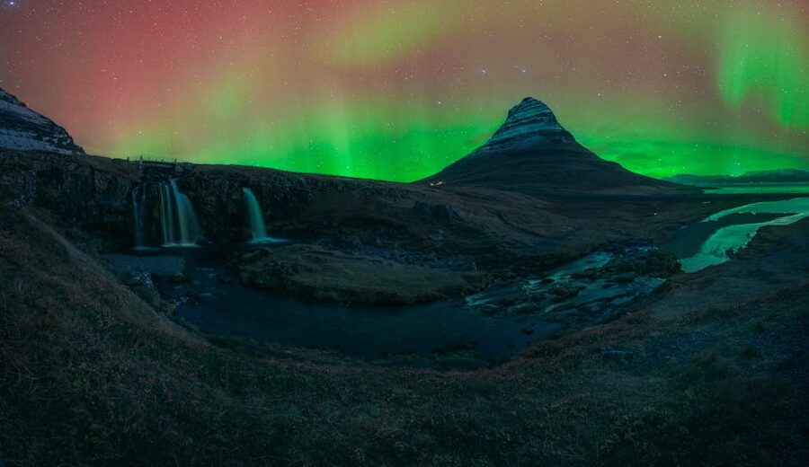
If you only do one geological thing in Iceland, do this one. Þingvellir (Thingvellir) National Park, an hour east of Reykjavik, is where the rift comes ashore in the south of the country. You can stand inside it. Almannagjá, “Everyman’s Gorge”, is a long, walkable cleft cutting north-south through the basalt. The wall on its western side is the easternmost edge of the North American tectonic plate. A few hundred metres to the east, the cliff at Hrafnagjá is the western edge of the Eurasian plate. In between is what geologists call a graben, a strip of land that has dropped down as the two sides pulled apart. The whole valley is being pulled open at the same 2 cm a year.
Þingvellir is also where Icelandic history began, which is why it is a UNESCO site twice over, once for nature and once for culture. The Vikings chose this spot for their annual parliament, the Alþingi, in 930 AD. Lögberg, the Law Rock, where the Lawspeaker recited the laws aloud once a year, sits at the foot of the western cliff. Most countries do not have a national park that is also their founding document. We are quietly proud of that one.
If you want to get even closer to the plate boundary, you can swim in it.
Silfra, snorkelling between two continents
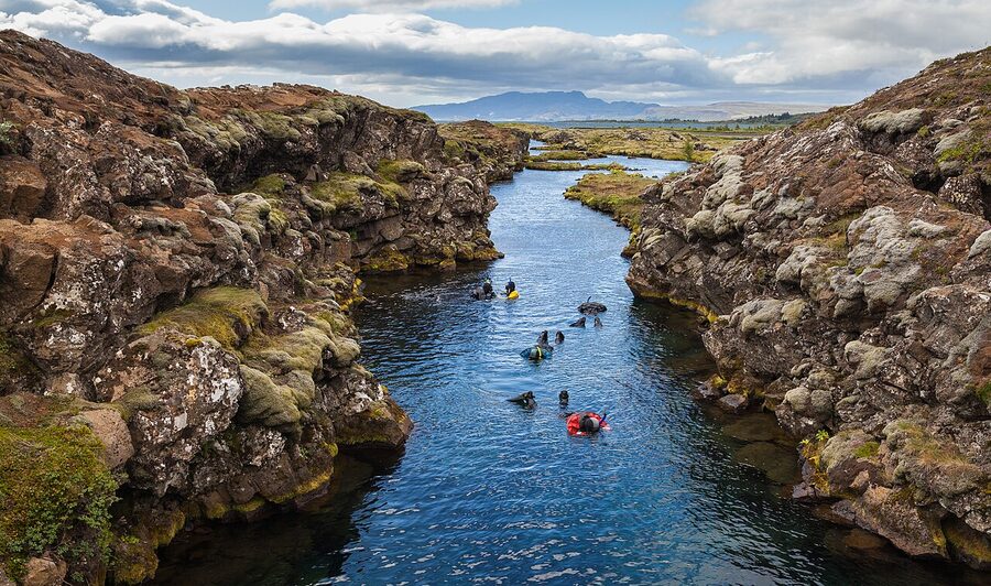
Silfra is a flooded section of the rift inside Þingvellir National Park. The water is glacial meltwater that has filtered for decades through the lava field of Langjökull, gradually working its way underground until it surfaces here. By the time you put a snorkel in, it has been naturally filtered to the point that it is, by every measurable standard, drinkable. Visibility regularly hits 100 metres. There is nowhere else like it.
You can snorkel or dive Silfra year-round. The water is 2 to 4°C every month, so dry suits are mandatory and operators provide them. Most snorkel tours run from May to September with the best light, but I have done it in February and the surface was clearer because there were no kayakers stirring the bottom up. Operators worth looking at are Dive.is and Arctic Adventures, both based in Reykjavik. Cost is around 22,000 to 28,000 ISK per person.
One quiet thing nobody tells you. The “touching two continents” line is real and not real at the same time. The plate boundary is not a single crack at Silfra, it is a 7 km wide rift zone, and you are floating somewhere in the middle of it. You are absolutely between the plates. You are not pressing both hands on the actual edges. It is still the closest you will ever get.
The Bridge Between Two Continents on Reykjanes
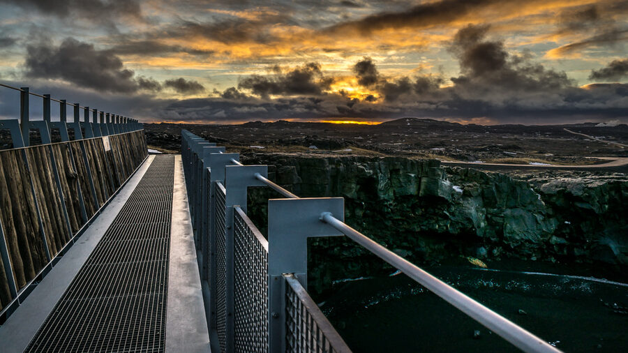
Out on the Reykjanes peninsula, fifteen minutes from Keflavik airport, somebody had the bright idea of building an actual little bridge across one of the smaller rift fissures and calling it the Bridge Between Two Continents. It is short. It is touristy. It is signposted off Route 425. And it is also, technically, true. You can walk from the North American plate to the Eurasian plate in about ten paces. Stop, take the photo, and then go and see Gunnuhver hot springs five minutes down the road, which is the more interesting site.
The volcanoes, what they are and which ones matter
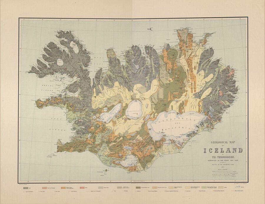
Iceland has roughly 30 active volcanic systems and somewhere around 130 individual volcanoes if you count carefully. They are organised in a broad belt that runs diagonally from the Reykjanes peninsula in the southwest, up through the south coast, across the centre of the country and out to the northeast at Krafla and Theistareykir. This belt sits more or less directly above the active part of the Mid-Atlantic Ridge. North of the Vatnajökull ice cap there is a parallel belt offshore, and there is a separate, less active line out on the Snæfellsnes peninsula in the west. The Westfjords and the eastern fjords are both old, calm, eroded volcanic country that has not erupted in millions of years. Where you stand on a map of Iceland tells you, more or less, how recently it was on fire.
Calling something an “active volcanic system” is a slightly stretched definition. It means the volcano has erupted within roughly the last 10,000 years, which is the geological present, not necessarily that it is going off this decade. The Icelandic Met Office (Veðurstofa Íslands), which is the authority on this, lists about 30 systems they actively monitor. The full list is on en.vedur.is and is the only volcano page on the internet you should trust for current status.
Let me walk you through the ones that matter.
Hekla, the gateway to hell
Hekla is the famous one. In the Middle Ages, monks across Europe wrote that it was the literal entrance to hell, partly because of the eruption noise carrying for hundreds of kilometres and partly because Iceland was as far north as anyone had heard of. The first recorded eruption was in 1104, which buried a sizeable Viking-age farming district, including a whole settlement called Þjórsárdalur that archaeologists still excavate today. Since then it has gone off more than twenty times.
What makes Hekla genuinely dangerous, and why we still keep an eye on it, is how little warning it gives. The eruption in 2000 was preceded by earthquake activity that the Met Office detected only about half an hour before lava came out of the ground. Most volcanoes give days or weeks of seismic notice. Hekla gives you time to move the car. The mountain has been quiet since 2000, which by historical pattern means it is overdue. Locals living between Hekla and the coast take this seriously and most own gas masks, which is a sentence that surprised me to write.
You can drive close to Hekla on Route 26, north from Selfoss. The summit hike is a long day, around 8 to 10 hours up and down, and only attempted in summer. There is no cable car and no path you would call developed. It is for people who have done a few hard hikes already.
Katla, sleeping under the ice
Katla is the one that worries volcanologists the most. It sits underneath the Mýrdalsjökull ice cap on the south coast, near the village of Vik. You will drive past it on the Ring Road and never see it, because the entire volcano is buried under 700 metres of glacier. Historically Katla erupts every 40 to 80 years. The last big eruption was in 1918. Do the maths.
The bigger problem with Katla is that the ice on top, when it suddenly melts, has to go somewhere. Big sub-glacial eruptions trigger a jökulhlaup, a glacial outburst flood, which is exactly what it sounds like. The 1918 jökulhlaup pushed enough sediment out of the glacier to extend the south coast at Vik by several kilometres in a few days. It is one of the reasons there is a black-sand outwash plain (the Mýrdalssandur) where there ought to be ocean.
You cannot really visit Katla as a volcano. You can do an ice-cave tour into Mýrdalsjökull, which I would gently suggest is more atmosphere than substance, the caves are more dust-lined than the famous blue ones in Vatnajökull. Worth pairing only if you are already on the south coast.
Eyjafjallajökull, the one nobody can pronounce
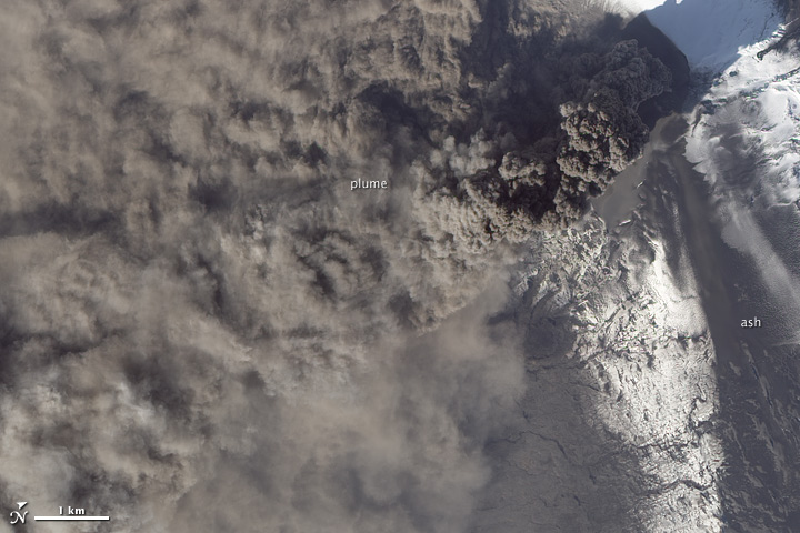
You know this one even if you don’t think you do. In April 2010 a relatively small eruption at Eyjafjallajökull, “the island-mountain glacier”, threw a dense ash plume eight kilometres into the atmosphere. The wind was just right to push it across northern Europe. Civil aviation authorities closed airspace from Ireland to Finland for six days, on and off for weeks. About ten million people were stranded. It cost the airline industry an estimated 1.7 billion EUR. And news anchors all over the world were given a phonetic spelling of “AY-uh-fyat-luh-yer-kutl” and asked to do their best.
It was not, by Icelandic standards, a particularly large eruption. It was just well placed. Eyjafjallajökull and Katla are linked. Historically every single Eyjafjallajökull eruption has been followed within a year or two by Katla. So far the 2010 one has not. Volcanologists are watching.
You can visit the Eyjafjallajökull visitor centre at Þorvaldseyri farm, on the Ring Road south of the volcano, where the family who lived through the eruption have built a little museum and screen a documentary. It is plainly told, sad in places, and worth the 1,500 ISK admission.
Bárðarbunga and the Holuhraun fissure, 2014 to 2015
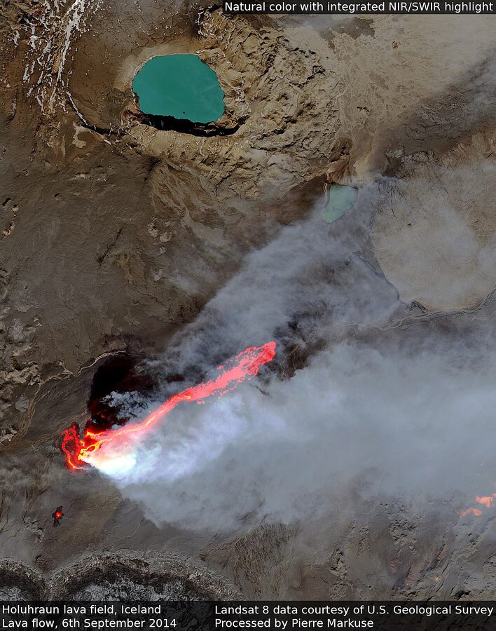
Bárðarbunga is a huge volcano sitting under the northern part of the Vatnajökull ice cap. In late August 2014 magma started moving sideways out of it underground, travelling about 45 km north until it broke the surface in an old lava field called Holuhraun, well clear of the ice. It then erupted continuously for six months. By the time it stopped in February 2015 it had produced about 1.6 km³ of lava, covering 85 km², an area larger than Manhattan and the biggest Icelandic lava flow in 230 years.
What was lucky is that it broke through outside the ice cap. If it had erupted under Vatnajökull, the resulting jökulhlaup would have been enormous and could have wiped out infrastructure all the way to the south coast. Instead, the only people in serious danger were a handful of tourists and scientists, who were all evacuated. The flood plain north of Vatnajökull is uninhabited.
The Holuhraun field is now solid black basalt and you can visit it on a long highland super-jeep tour out of Mývatn, mid-June to early September only. It is a 12-hour day. Worth doing if you have the time and a strong back. Do not try to drive yourself, the F-roads in are river-crossing F-roads and rental insurance does not cover them.
Grímsvötn, the most active volcano you have not heard of
Grímsvötn (the “grim waters”) sits under Vatnajökull and is, by frequency of eruption, the most active volcano in Iceland. It goes off on average every five to seven years. The 2011 eruption produced a much bigger ash plume than the 2010 Eyjafjallajökull event, but the wind blew it out to the Atlantic instead of over Europe, so nobody outside Scotland noticed. It also caused jökulhlaups out of the southern edge of Vatnajökull, and the Skaftá river flooded so badly that the Ring Road bridge had to be replaced.
You cannot visit Grímsvötn directly, it is genuinely under a glacier. But you will cross the meltwater outflow plain at Skaftá on the Ring Road if you drive between Vik and Höfn, and you can sometimes see steam coming off the ice cap from a distance.
Askja, the 1875 caldera
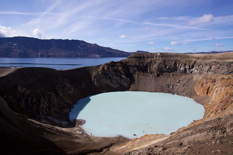
Askja is a giant caldera way up in the central highlands, north of Vatnajökull. It blew its top spectacularly in 1875, ejecting so much ash that crops failed across Iceland and a wave of emigration to North America followed. The 1907 expedition led by the German geographer Walter von Knebel went to map the new caldera lake and never came back, the team’s bodies were never found, and the lake has been quietly carrying that story ever since.
You can visit in summer, late June to early September only, but it is committed work. The road in is the F88, a long bumpy highland track that crosses several rivers and is 4×4 only. Most people go on a day tour out of Mývatn or Akureyri, departing around 8 AM and back by 9 PM. The walk from the car park to the crater rim is about 45 minutes each way. The smaller crater Víti, next to the lake, has bath-temperature geothermal water you can swim in. Bring a towel and shoes you do not mind ruining on the sulphurous mud.
Krafla and the Mývatn fires, 1975 to 1984
Krafla, in the north near Lake Mývatn, had a long, slow series of eruptions called the Krafla fires from 1975 to 1984. Nine separate events over nine years from the same fissure system. It was useful in a way no eruption usually is: it interrupted construction of the Krafla geothermal power plant, which engineers had to redesign on the fly. The plant is now operational and generates 60 MW.
What is interesting about Krafla now is the IDDP, the Iceland Deep Drilling Project. In 2009 they drilled a borehole and unexpectedly hit magma at 2.1 km depth, much shallower than anyone expected. The well was producing the hottest steam ever recorded from a borehole, around 450°C, which would have been groundbreaking for energy if the well casing had not corroded and failed. They are planning to do it again. Drilling into magma to extract heat directly is a very Icelandic engineering ambition.
You can visit Krafla easily. The Leirhnjúkur lava walk, about a 5 km loop from a free car park north of the power plant, takes you across cooled flows from the 1984 eruption. Some of the ground is still warm under your feet in places, and you can see steam coming up through cracks. Pair it with the Námafjall geothermal field 10 minutes south, which is the next section.
Laki, 1783, the eruption that changed Europe
Laki deserves its own paragraph because it is the worst thing that ever happened to Iceland and one of the worst things that ever happened to Europe in the 18th century. In June 1783 a 27 km long fissure opened up south of the Vatnajökull ice cap and erupted, on and off, for eight months. It produced about 14 km³ of lava, the biggest single basaltic lava flow in human history, and clouds of sulphur dioxide and fluorine that killed roughly 80% of Iceland’s livestock. The “Móðuharðindin”, the “Mist Hardships”, followed: a quarter of the human population starved. Iceland’s population dropped from around 50,000 to 38,000 in two years.
The sulphur cloud drifted south. Western Europe had its hottest July on record followed by one of the coldest winters of the century. Crop failures contributed to French food shortages that historians sometimes connect, indirectly, to the discontent that boiled over in 1789. It is the only volcanic eruption I know of that you can plausibly link to the French Revolution.
The Laki craters are visitable in summer on a long highland tour. They are a row of 130 small cones, beautifully aligned, in genuinely lonely country. Hand on heart, this is the most impressive geological day trip in Iceland and almost nobody does it. Tour operators include Iceland Travel and Reykjavik Excursions, both running June to September only.
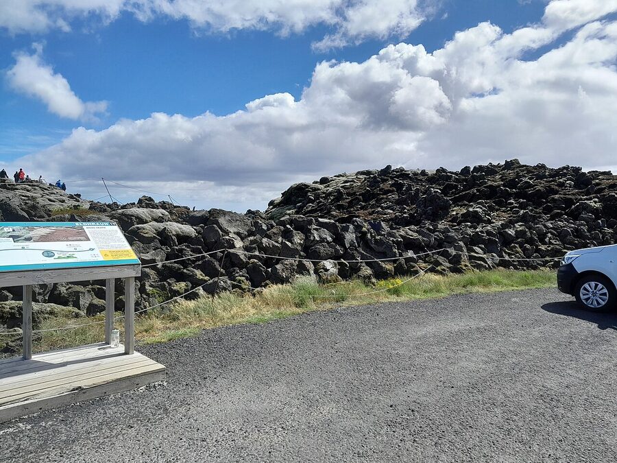
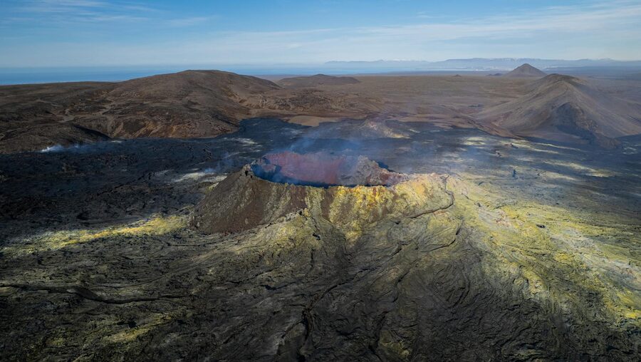
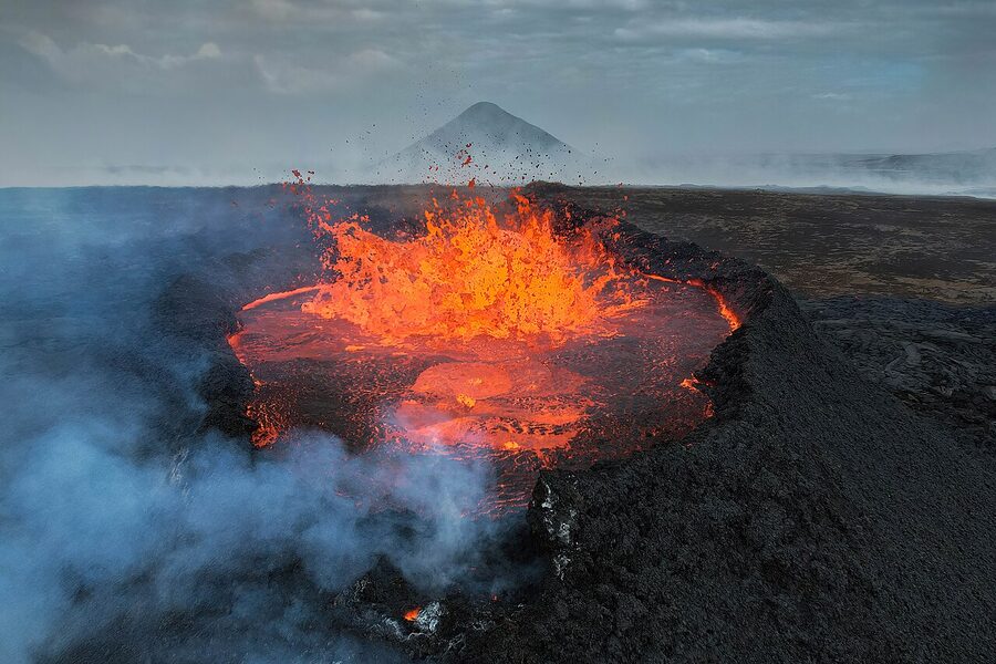
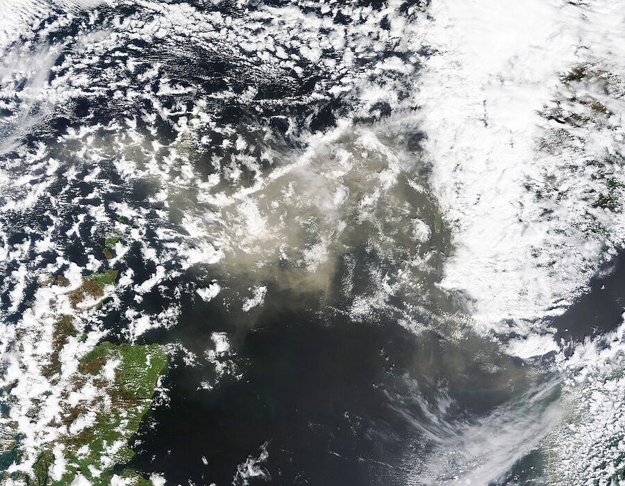
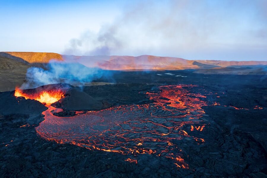
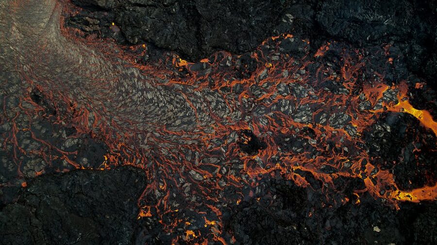
Reykjanes and the new fires, 2021 to now
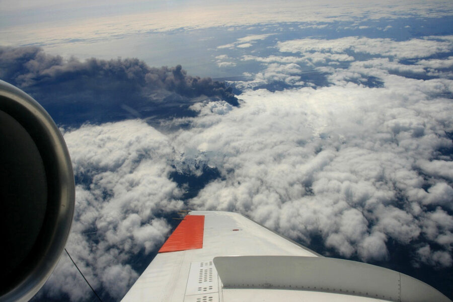
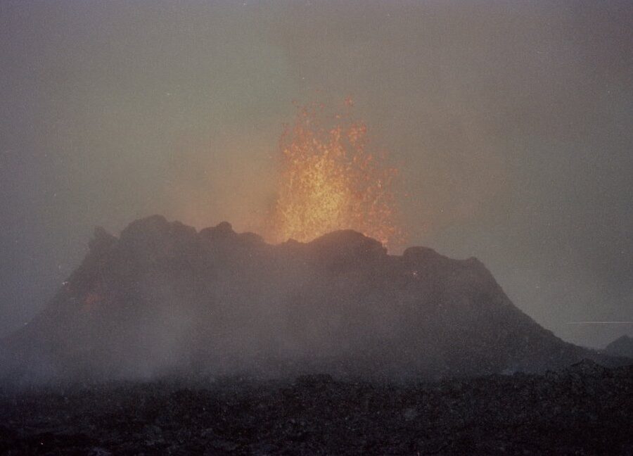
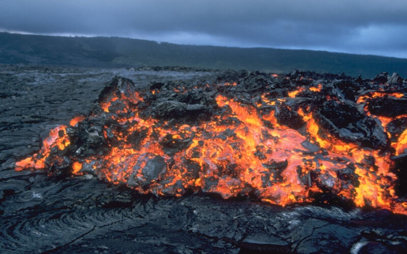
For 800 years the Reykjanes peninsula, the bit of Iceland that you fly into, was geologically quiet. Then in March 2021 a small fissure opened up at Geldingadalir, near Fagradalsfjall, and started gently erupting bright orange basalt. It went on for six months. Tourists and locals walked out to the edge in their thousands. It was a tame, photogenic, almost friendly eruption, the kind volcanologists call effusive. Reykjavik bus operators ran shuttle buses to the trailhead.
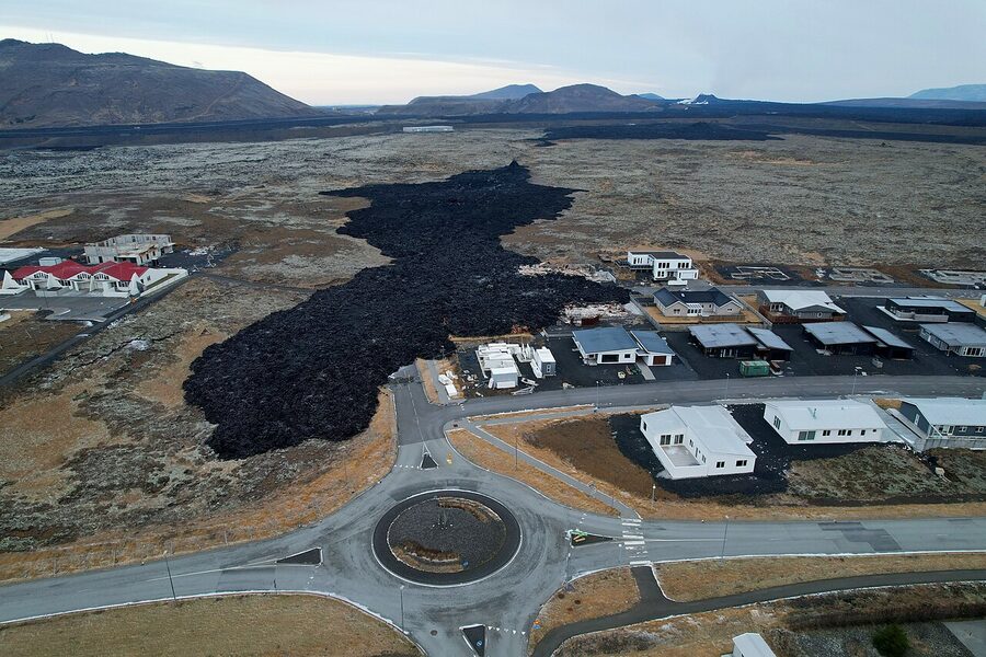
What we did not understand at the time was that this was the start of a new active period. Since 2021 there have been eight eruptions on Reykjanes, none of them especially big, but several of them serious. The town of Grindavík (population about 3,400) was evacuated in November 2023 after a major fissure opened up underneath it and started cracking the streets. A magma intrusion damaged houses, broke water pipes, and made parts of the town genuinely uninhabitable. There were further eruptions through 2024 and into 2026. The town is still partially evacuated. The Blue Lagoon has had to close repeatedly. As of writing, lava has crossed the road to Grindavík four times in the past two years.
This matters for visitors in two ways. One, you can sometimes see the eruptions from the air on landing or take-off at Keflavik, which is unforgettable. Two, no eruption has ever come close to the airport itself, and air travel has been disrupted only twice and briefly. Iceland has been operating on the basis that life continues. Tours run, hotels stay open. Just check en.vedur.is the morning of any tour to see what is happening, and trust local operators to know when to cancel.
Whether you can hike to the most recent flow depends on which week you are reading this. Safetravel.is publishes the official current trail status, gas levels, and access rules. Do not freelance it, the gas can be lethal in bad wind conditions and rangers shut hikes for good reasons.
Þríhnúkagígur, the volcano you can climb inside
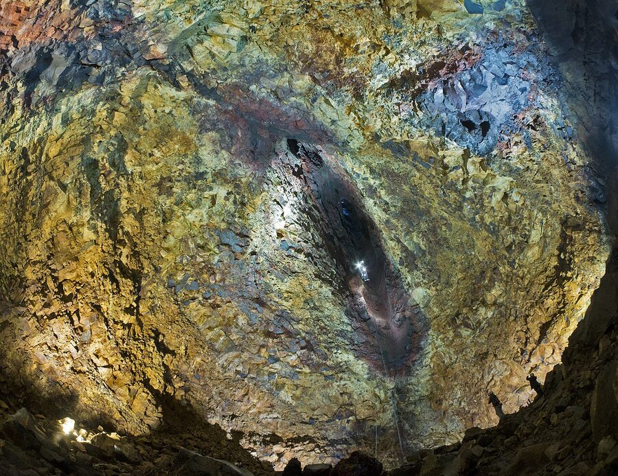
The strangest geological tour in the world is also one of the easiest to book. Þríhnúkagígur is a small dormant volcano about 30 minutes from Reykjavik. About 4,000 years ago it erupted, and when the eruption ended the magma in its central conduit drained back down into the Earth instead of solidifying inside. What is left is an empty, intact, cathedral-sized magma chamber. You go in.
The descent is in an open basket, the same kind of platform window-cleaners use on tall buildings, lowered down a 120-metre shaft. The chamber at the bottom is enormous, the size of three basketball courts stacked, with mineral-streaked walls in colours that look unreal because no daylight has touched them. It opened to the public in 2012, runs from mid-May to late October only, and costs around 65,000 ISK. Booking is via Inside the Volcano. There is genuinely nowhere else on Earth you can do this.
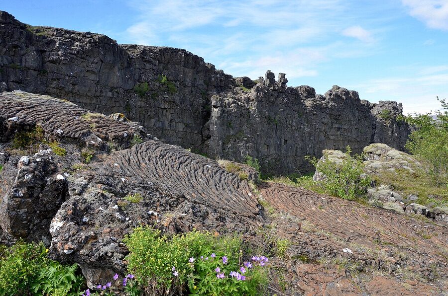
What the rocks look like and why
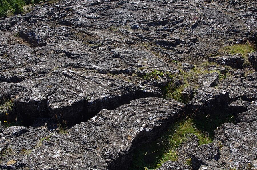
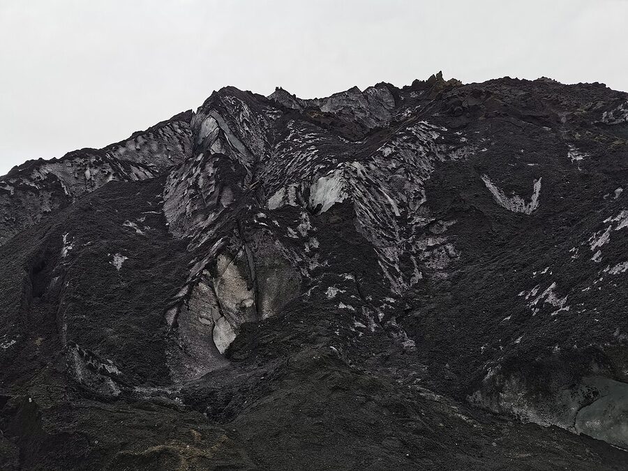
Almost everything you see in Iceland is some form of basalt. Basalt is the most common volcanic rock on the planet and the rock that is built when oceanic crust forms at mid-ocean ridges. It is dark grey to black, fine-grained, and rich in iron and magnesium. The mountains are basalt, the cliffs are basalt, the black sand on the beaches is ground-up basalt, the kerbstones in Reykjavik are basalt. Get used to it.
Lava in the field comes in two main flavours. Both have Hawaiian names because Hawaiian volcanologists got there first.
Pahoehoe (pa-HOY-hoy) is hot, runny lava that cools with a smooth or ropy skin. The surface looks like wrinkled fabric or coiled rope. Þingvellir has classic pahoehoe.
Aa (ah-ah) is cooler, more viscous lava that breaks up into a clinkery, jagged, ankle-snapping mess as it advances. The same eruption can produce both, depending on where the lava is in its flow. Most Icelandic eruptions in the last few decades have produced more aa than pahoehoe.
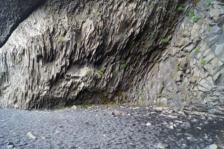
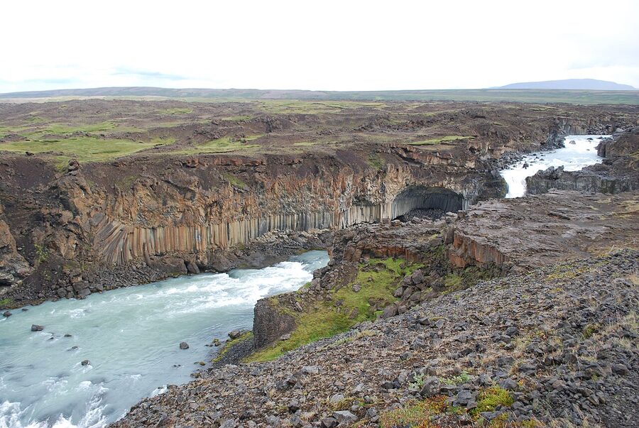
And then there are the columns. When a thick basalt flow cools slowly, it shrinks. As it shrinks, it cracks in a hexagonal pattern from the top down, creating those vertical, six-sided columns you see at famous spots like Reynisfjara and Svartifoss. The geometry is a function of how fast the rock cools. Slower cooling, taller and more regular columns. The country is full of them.
Reynisfjara, the columns at the beach
Reynisfjara, on the south coast just past Vik, is where most people meet Icelandic basalt for the first time. The beach is jet black, the cliffs are stacks of perfect hexagonal columns, and the sea-stacks called Reynisdrangar rise out of the ocean offshore. Free, on the Ring Road, parking 1,000 ISK.
One important thing. Reynisfjara has dangerous sneaker waves. The Atlantic here regularly throws up rogue waves that are much bigger than the rest, with no warning. People have been killed at Reynisfjara within the last few years, washed off the beach in calm-looking weather. Stay well back from the waterline, watch the warning lights, and take the signage seriously. It is not a normal beach.
Svartifoss, the church-organ waterfall
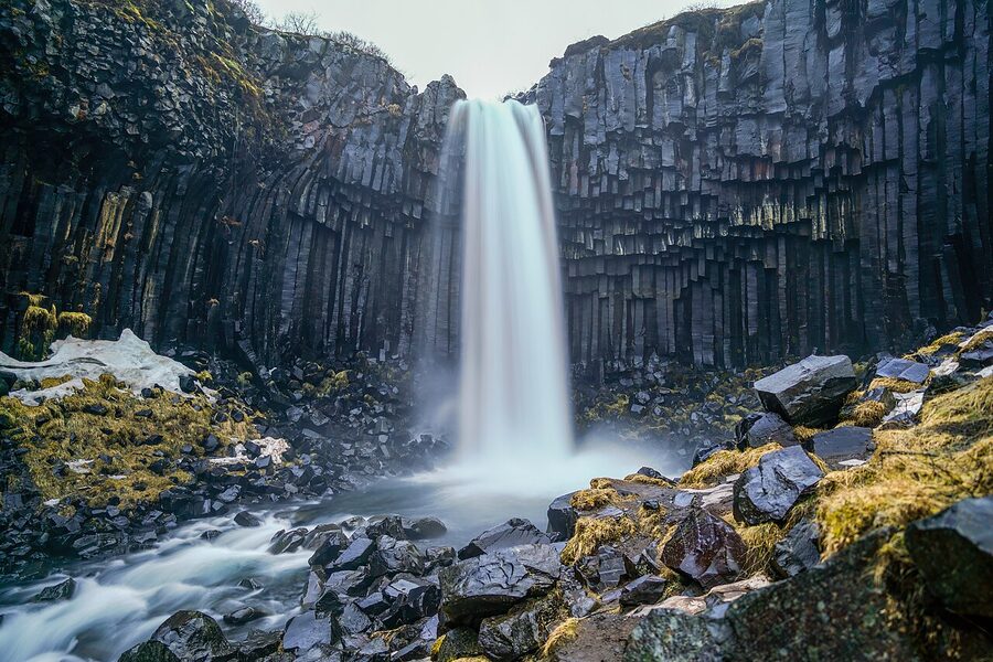
Svartifoss is in Skaftafell, part of Vatnajökull National Park on the south coast. About a 1.5 km uphill walk from the visitor centre. The waterfall is small but the framing is unforgettable, a curtain of long, dark basalt columns hanging like organ pipes. The architect Guðjón Samúelsson copied this exact rock formation when he designed Hallgrímskirkja, the famous Reykjavik cathedral, in the 1930s. Stand at the bottom of Svartifoss and you are looking at the building’s blueprint.
Stuðlagil, the canyon discovery
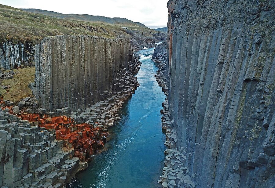
Stuðlagil is a recent discovery, in the sense that it has only been visible since 2009. Until then the Jökla river ran high in the canyon, hiding the basalt columns at the bottom. Then the Kárahnjúkar hydroelectric dam upstream diverted most of the river and the water level dropped about ten metres. The columns appeared. Photographers found out around 2017. Now it is one of the busier stops in east Iceland.
Stuðlagil is off Route 1 in the eastern fjords, between Egilsstaðir and Mývatn. There are two access points, the easy north side (just walk to the viewpoint) and the demanding south side (a long muddy trail down). The north side gives you the postcard photo. The south side gets you down to the water. Pick based on shoes.
Aldeyjarfoss, the columns and the curtain
Aldeyjarfoss in the north, at the southern end of the highland road F26, is the same idea as Svartifoss but bigger and wilder. A heavy waterfall plunging over a wall of basalt columns into a stone bowl. Less visited because it requires a 4×4 and a willingness to drive 30 km of dirt. If you have the vehicle and the day, do it. The closest town is Akureyri, about 90 minutes north on the surfaced road then another hour on F26.
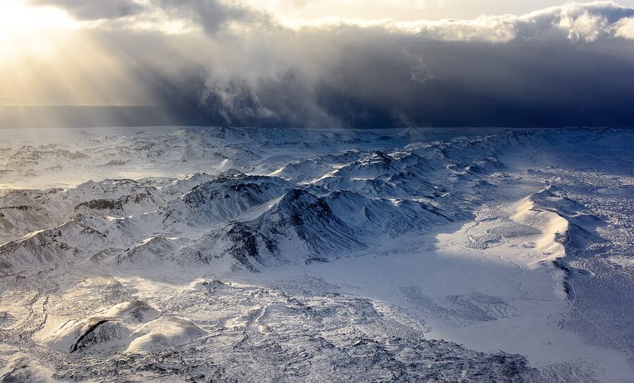
The glaciers, eleven percent of the country under ice
About 11% of Iceland is under glacier ice. The big six ice caps, in order of size, are Vatnajökull (7,900 km²), Langjökull (840 km²), Hofsjökull (827 km²), Mýrdalsjökull (590 km²), Drangajökull (160 km², the only one in the Westfjords) and Snæfellsjökull (10 km², the small but iconic cap on the western peninsula). Then there are dozens of smaller glaciers and outlet tongues feeding off the big ice caps.
Most Icelandic glaciers sit on top of volcanoes. This is unusual and important. When a sub-glacial volcano erupts, the heat melts the ice from underneath and the resulting meltwater builds up under the glacier until pressure forces it out, often catastrophically. That is the jökulhlaup I keep mentioning. The 1996 Gjálp eruption under Vatnajökull triggered a flood that pushed 3 km³ of water out from under the ice in a few hours, destroying the Ring Road bridge over the Skeiðará river.
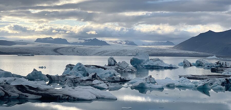
Vatnajökull, the big one
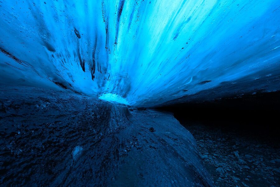
Vatnajökull is the obvious one. It is huge, it covers volcanoes, and it has the most accessible ice caves and outlet glaciers. From mid-November to late March a handful of guided tour operators take small groups into ice caves under the glacier. The caves change every year, sometimes every week. Local Guide of Vatnajökull and Glacier Adventure are two of the operators I would trust. Tours start from Jökulsárlón or from Hali Country Hotel and run around 25,000 to 35,000 ISK depending on which cave is open.
Vatnajökull also drives most of the visitable glacier landscape on the south coast. The Skaftafell area, an hour west of Höfn, has half a dozen short walks to outlet glaciers and is where most glacier hikes start. Vatnajökull National Park covers about 14% of Iceland and is the largest national park in Western Europe.
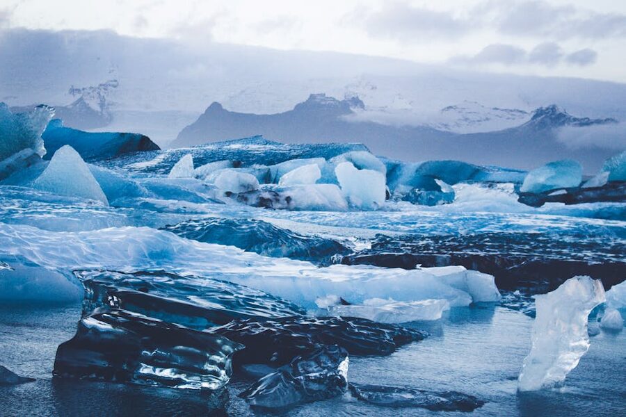
Jökulsárlón, the lagoon at the front
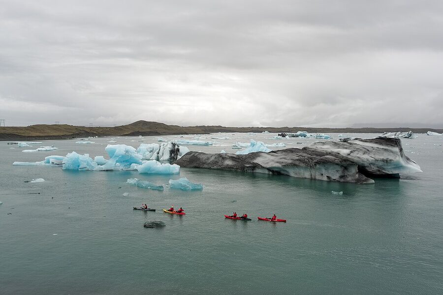
Jökulsárlón (“glacier-river-lagoon”) is the most photographed glacier scene in Iceland and for good reason. The lagoon at the snout of the Breiðamerkurjökull outlet glacier did not exist before about 1934. As the glacier retreats, the meltwater pool behind it has grown to around 20 km², now the deepest lake in Iceland at about 250 metres. Icebergs calve off the front of the glacier into the lagoon, drift around for months or years, then eventually wash out to sea, get rolled by the Atlantic and stranded back on the black-sand beach across the road. Locals call that beach Diamond Beach. Free to visit, parking 1,000 ISK, on the Ring Road about an hour east of Vik.
Boat tours run on the lagoon mid-May to October, both amphibious vehicles (slower, less close to the icebergs) and Zodiac boats (faster, much closer, much wetter). Around 6,500 ISK for the amphibious boat, around 11,000 ISK for the Zodiac. The Zodiac is the better one. It is 40 minutes of close-up iceberg photography and a few seal sightings if you are lucky.
Sólheimajökull, the easy outlet
Sólheimajökull is an outlet of the Mýrdalsjökull ice cap (yes, the one over Katla), a half-hour drive west of Vik on the Ring Road then 5 km up Route 221. From the car park the walk to the glacier front is about 30 minutes. You can stand at the snout for free. To actually walk on it you need a guide, and you should, because crevasses are not optional. Arctic Adventures, Glacier Guides and Trolltour all run morning hikes for around 13,000 to 17,000 ISK. The crampons are provided.
Sólheimajökull has retreated about 1.5 km since 1995. There are old photographs at the visitor stop showing the glacier reaching the parking lot. Standing at the current snout and looking back at the photo posts is the most physical reminder of climate change you can get in Iceland. It is sobering.
Snæfellsjökull, the cap of the western peninsula
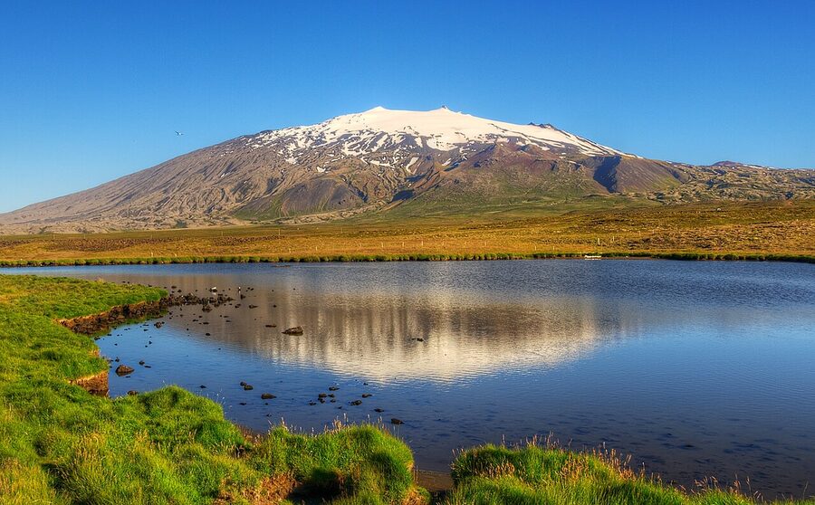
Snæfellsjökull is the small glacier on top of a stratovolcano at the western tip of the Snæfellsnes peninsula. Total area about 10 km², small enough that on a clear day in Reykjavik 120 km away you can see it across the bay. The volcano underneath is dormant, last erupted about 1,800 years ago.
Snæfellsjökull is the volcano Jules Verne picked as the entrance to the centre of the Earth in his 1864 novel. It is also the centrepiece of Snæfellsjökull National Park. Worth a day trip out from Reykjavik even if you only drive around the base. The hiking and snowmobile tours up to the summit are well organised by Snæfellsjökull Glacier Tours and run from April to August.
Okjökull, the glacier that died
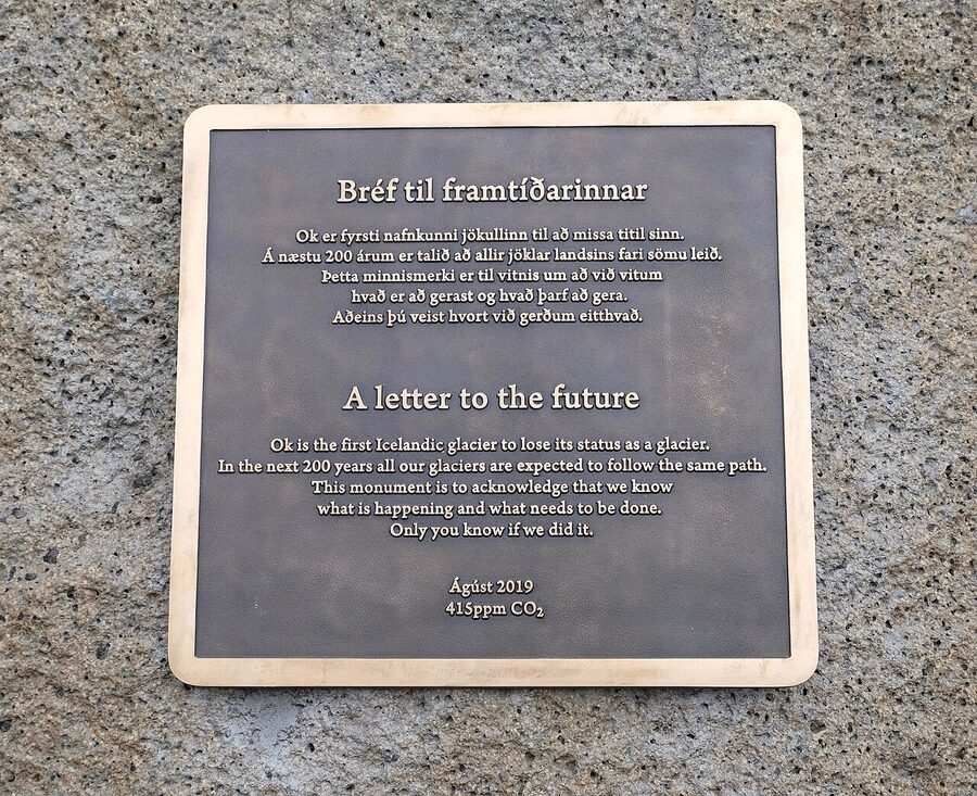
And then there is Ok. Okjökull was a small ice cap on top of the Ok volcano in west Iceland. In 2014 the glaciologist Oddur Sigurðsson formally declared that Ok was no longer a glacier, the ice was too thin to flow under its own weight, which is the working definition. In 2019 a small ceremony was held on the bare rock and a plaque installed. It reads, in Icelandic and English, “Ok is the first Icelandic glacier to lose its status as a glacier. In the next 200 years all our glaciers are expected to follow the same path. This monument is to acknowledge that we know what is happening and what needs to be done. Only you know if we did it.” It is signed by the date and 415 ppm, the atmospheric CO₂ concentration on the day. The walk in is about 2.5 km uphill from a small parking area off Route 550 near Húsafell. Worth doing once.
Geothermal Iceland, where the heat actually goes
Surface volcanism is the thing tourists fly over to see. The quieter, deeper story is the geothermal: hot water and steam moving through fractures in the crust, then coming up through wells or hot springs. About 65% of all primary energy use in Iceland is geothermal. Around 90% of homes are heated with it. Most of Reykjavik’s hot tap water comes straight out of the ground.
The big geothermal plants are Hellisheiði (303 MW, Iceland’s biggest, supplies most of Reykjavik) and Nesjavellir (120 MW), both on the Hengill volcanic system 30 minutes east of the capital. Both have visitor centres, both are open 9 to 5, and Hellisheiði’s exhibition is genuinely interesting if you have any engineering bent. Admission to the Hellisheiði exhibit is around 2,000 ISK, includes coffee.
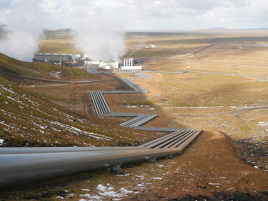
The bonus from heating Reykjavik geothermally is that the cold-side return water is still 70 to 80°C and gets used to heat the city’s roads and pavements. In central Reykjavik the snow simply melts off Laugavegur (the main shopping street, named for the geothermal washing-springs that used to be there) all winter. Climate-friendly, ridiculously expensive, and we have come to expect it.
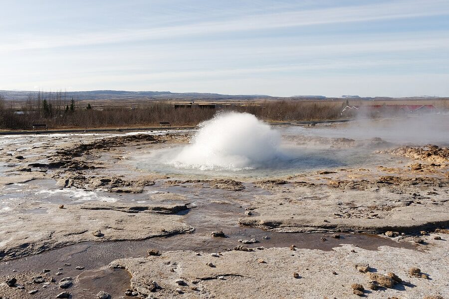
Strokkur and the geyser that named them all
The original Geysir, in the Haukadalur valley about an hour and a half east of Reykjavik on the Golden Circle route, is where the English word “geyser” comes from. The Icelandic verb “geysa” means to gush. Geysir itself has been quiet since the 1960s, with rare exceptions, but its smaller neighbour Strokkur (“the churn”) goes off every 6 to 10 minutes like clockwork, with a 20 to 30 metre column of water and steam. Free to visit, parking 1,000 ISK, busy in the middle of the day, much better at 9 AM or after 6 PM. Pair it with Þingvellir and Gullfoss to make the Golden Circle, the most popular day trip from Reykjavik. Our glaciers and geysers tour guide goes deeper into the Golden Circle route.
Hverir, the boiling earth
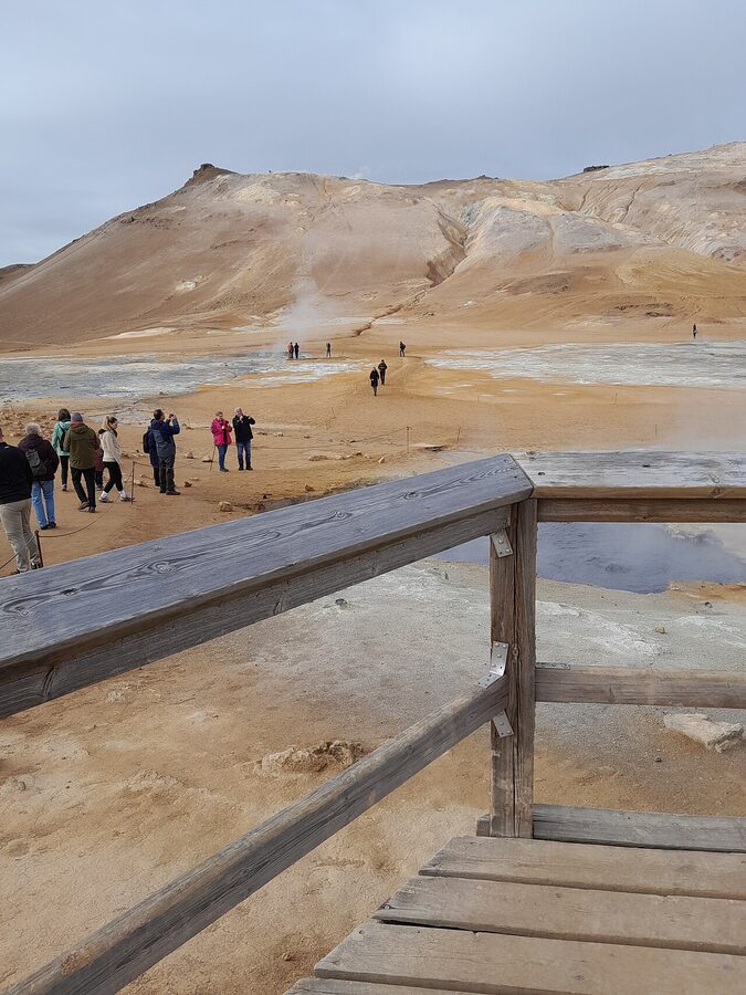
Hverir, on the Námaskarð pass east of Lake Mývatn in the north, is the most accessible high-temperature geothermal field in Iceland. Boiling mudpots, fumaroles screaming with steam, the ground stained yellow with sulphur, the smell unforgettable. It looks like a film set for a planet that has gone wrong. Free, parking is 1,000 ISK, just off Route 1.
Stay on the marked paths. The ground crust between mudpots is sometimes only a few centimetres thick over boiling water, and people get hurt every year. The smell of rotten eggs is hydrogen sulphide, harmless in small doses, slightly unpleasant the first time, normal by your second visit.
The hot pots, why every village has one
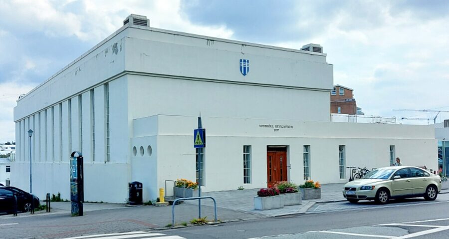
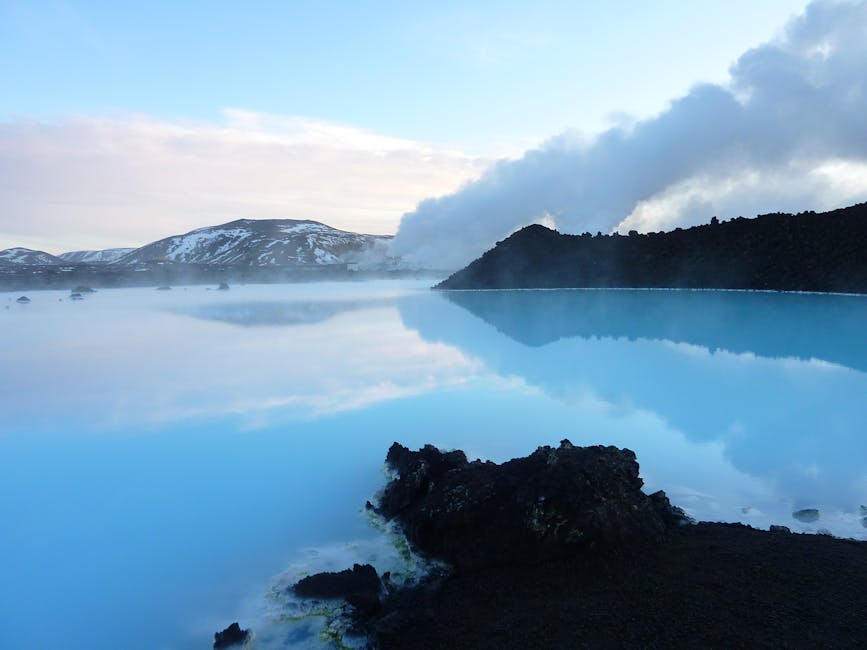
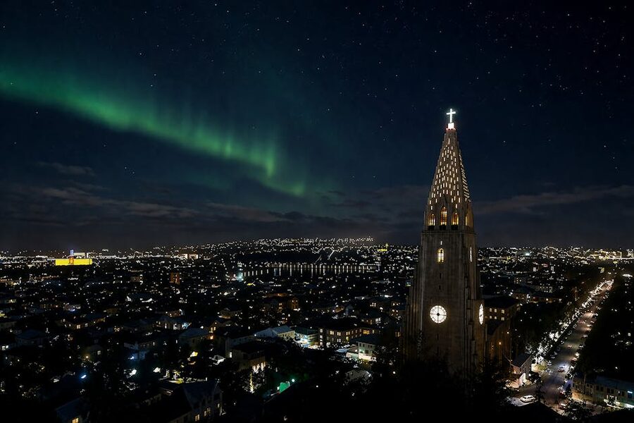
The geological story above is what makes possible the most quietly Icelandic thing about Iceland: there is a hot, geothermally-heated outdoor pool (“sundlaug”) in basically every village, with a series of “heitir pottar” (hot pots) at varying temperatures around the edge, usually 38, 40 and 42°C. Even Reykjavik has a dozen pools. They cost 1,200 to 1,500 ISK to enter, are open from early morning until late evening, and are the actual centre of social life in winter. Tourists go to the Blue Lagoon and Sky Lagoon, which are fine. Locals go to Laugardalslaug and Vesturbæjarlaug. If you want to feel what Iceland is like, skip the lagoon admission for one day and go to a town pool. You will pay one tenth as much and have ten times the experience.
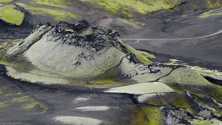
Lava fields, pseudocraters, and the alien landscape
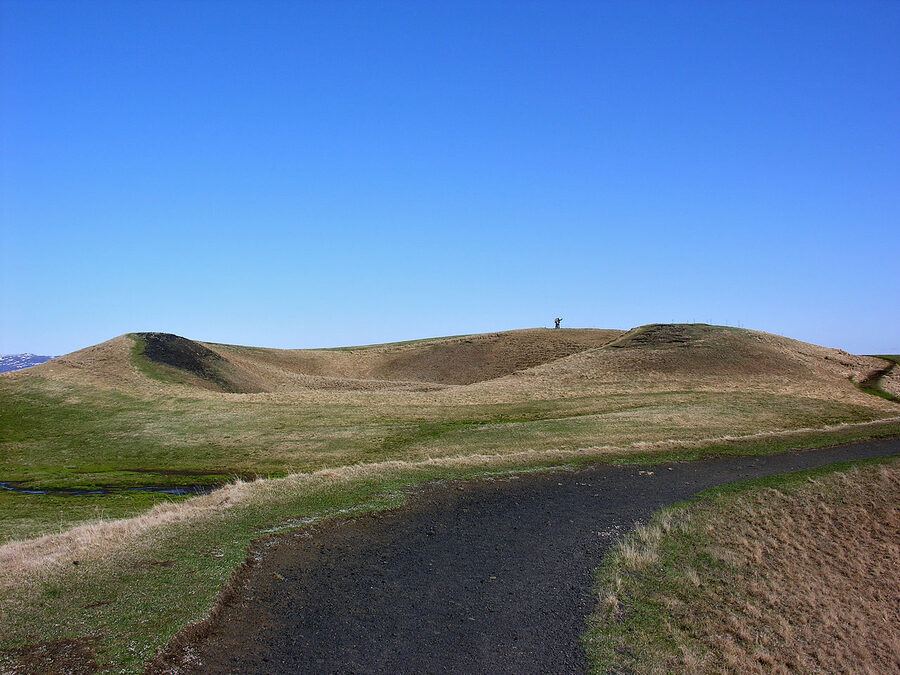
Pseudocraters are one of the most Icelandic things. They look exactly like small volcanoes, perfect cones with a depression in the middle, but they never erupted. They form when a lava flow runs over wet ground or shallow water and traps the moisture underneath, which flashes to steam, which then explodes upward through the still-cooling lava and throws out a cone of material around the vent. The most famous group is at Skútustaðagígar on the south shore of Lake Mývatn. There is a signposted loop walk of about 1 km, completely free, just off Route 1.
Dimmuborgir, the dark castles
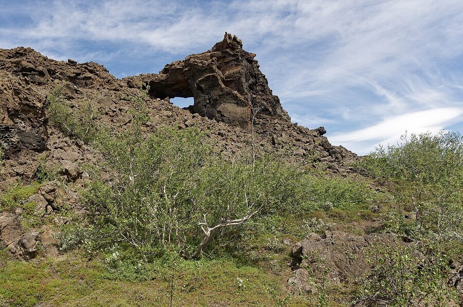
Just north of Skútustaðagígar at Mývatn is Dimmuborgir, “the dark castles”. A field of lava arches, towers and short caves, formed when a shallow lava lake drained from underneath 2,300 years ago and the crust above it collapsed inward in places and stood up in others. There are several signposted walking loops, the shortest is about 800 metres, the longest about 4 km. Free entry, parking 1,000 ISK. Folklore says it is where the Yule Lads, our 13 mountain trolls, come down from at Christmas. (More on that in our Christmas in Iceland article if you are curious.)
Hverfjall, the perfect tephra cone
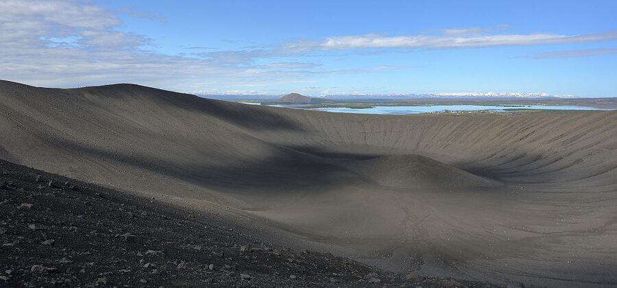
Across the road from Dimmuborgir is Hverfjall, a tephra ring crater nearly a kilometre wide and 140 metres high, formed in a single short explosive eruption about 2,500 years ago. The hike up the scree path takes about 30 minutes. The view from the rim looks straight down into a perfect bowl with no lava in the bottom, then north across Lake Mývatn. Free, no facilities. Wear actual shoes, not sandals.
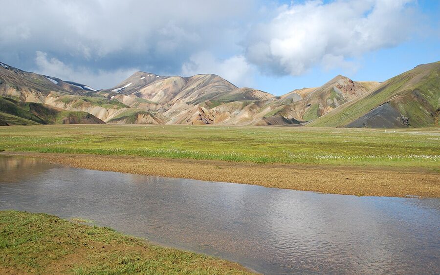
Landmannalaugar, the rhyolite mountains
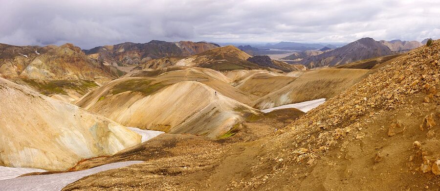
Most of Iceland is grey and black basalt. The exception is Landmannalaugar, a small valley deep in the central highlands, where the rocks are rhyolite, a more silica-rich lava that comes in pinks, oranges, ochres and greens depending on which minerals are weathering. The result is a landscape that genuinely looks like a different planet. Hot stream beside the campground, dramatic ridge walks above. The famous Laugavegur multi-day hike (4 days from Landmannalaugar south to Þórsmörk, 55 km) starts here. Highland tracks F208 and F225 only, 4×4 only, mid-June to early September. Most visitors take the bus from Reykjavik, around 11,000 ISK each way.
Surtsey, the youngest island in the world
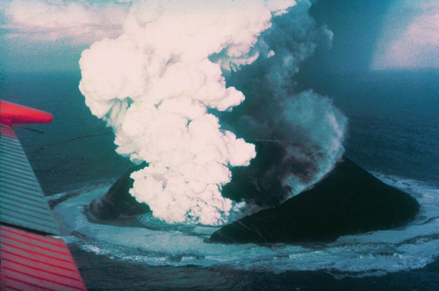
On 14 November 1963, a fishing boat off the south coast watched smoke rising from the sea. Within days a new island had broken the surface. The eruption continued for three and a half years and built an island of about 2.7 km², which UNESCO promptly closed to all visitors except scientists. They have spent 60 years documenting how life arrives on bare new land. Bacteria came first, then mosses, then a few hardy plants, then nesting birds. Today Surtsey has plants, insects, and a small puffin colony. The island has eroded by about half since 1967 and will probably continue to shrink, but the rocky core will be there for centuries.
You cannot land. You can see it on a clear day from the Vestmannaeyjar (Westman Islands) ferry, or take a flight over from Reykjavik with Atlantsflug, around 65,000 ISK per person. The most you will get from the ground is a postcard view from the Vestmannaeyjar harbour 18 km away.
The basalt-and-moss landscape that trained astronauts
In the summers of 1965 and 1967, NASA brought 32 of the Apollo astronauts to Iceland for two-week field training expeditions. Neil Armstrong, Buzz Aldrin, the whole bench. The chosen training sites were Askja, the lava field around Mývatn, the Hekla area, and the highlands east of Húsavík. The reasoning was simple: the basaltic, lifeless, broken, lunar-looking terrain at these sites was as close to what they expected on the Moon as anywhere accessible on Earth. They practised geological mapping, sampling, and identifying volcanic rock types. Apollo 11 brought back rocks. The astronauts knew what they were looking at partly because they had spent two weeks looking at the same kind of rock north of Húsavík.
The town of Húsavík has a small Exploration Museum that documents this, well worth an hour. Húsavík is also the best whale-watching town in Iceland, so pair the museum with a trip out on the bay. (You can read more about Iceland’s wildlife on our animals of Iceland page.)
Climate change and the glaciers, what is actually happening
Icelandic glaciers have lost about 18% of their mass since 1890. About two-thirds of that loss has been since 1995. Vatnajökull has thinned by an average of 40 metres in 30 years. Sólheimajökull has retreated 1.5 km since the late 1990s. Drangajökull, in the Westfjords, is the only one that has held more or less steady. All the others are losing ice every year, and the National Glaciological Society of Iceland projects that almost all Icelandic glaciers will be gone within 200 years if current trends continue. Some of the small ones are expected to disappear within decades.
This affects more than the view. As ice loads come off the volcanoes, the underlying rock rebounds upward, which reduces pressure on the magma below, which probably increases eruption frequency. Studies of Vatnajökull suggest that volcanic activity in Iceland could rise by around 30% as the ice cap thins through this century. So fewer glaciers, more eruptions. A bleak trade.
The visible thing for travellers is that the iconic glacier views are changing year by year. The blue ice caves under Vatnajökull will eventually close as the glacier retreats past their entry points. Several outlet glaciers that were walked on routinely in the 1990s are now too crevassed and unstable to access. If you ever wanted to see this, soon is better than later.
How to actually see the geology
Stripped down to a planning checklist, here is how I would tell a friend to see Iceland’s geology in three different lengths of trip.
Three days from Reykjavik. Day one, the Golden Circle: Þingvellir, Geysir/Strokkur, Gullfoss. Day two, the south coast as far as Vik: Eyjafjallajökull visitor centre, Sólheimajökull glacier walk if guided, Reynisfjara basalt columns, sleep in Vik. Day three, drive back via Þríhnúkagígur (book the inside-the-volcano tour months in advance) and a Reykjavik thermal pool to recover.
One week. Add Vatnajökull. Drive the Ring Road south coast as far as Höfn. Skaftafell for half a day, Jökulsárlón and Diamond Beach for an afternoon, ice cave tour in winter or glacier walk in summer. The Eldhraun lava drive between Kirkjubæjarklaustur and Skaftafell is one of the great roads in the world. Loop back the same way or go on round.
Ring Road, ten to fourteen days. Now you can fit in the north. Mývatn for three nights minimum: Krafla, Hverir, Dimmuborgir, Skútustaðagígar, Hverfjall, the lava walks at Leirhnjúkur. Add a day tour to Askja or Holuhraun if you have the legs. Húsavík for the Exploration Museum and whale watching. Snæfellsjökull on the way back from the north if you have one extra day.
For self-drive, get a 4×4 if you have any plan to leave the surfaced roads. F-roads (highland tracks) require a 4×4 by law and rental insurance does not cover river crossings, so be careful. We have a guide to day tours from Reykjavik if you would rather skip the rental and have someone else drive.
For something more guided and geology-focused, both photo tours and tailored small-group tours can be designed around the rocks. Specialist operators like Iceland Geology Tours and Hidden Iceland run dedicated geology trips with proper guides.
Watching for the next eruption
People sometimes ask me whether to cancel a trip because Reykjanes is erupting again. Almost always the answer is no. The eruptions are localised, well monitored, and rarely close anything but the immediate area and the road to Grindavík. Keflavik airport has remained open through every event since 2021. Tour operators are conservative about cancellations and have plans for everything. The country has been doing this for 1,150 years.
That said, the one website worth bookmarking is en.vedur.is/earthquakes-and-volcanism, the Icelandic Met Office. They publish current alert levels for every monitored volcanic system, daily earthquake maps, hazard updates, and gas-pollution forecasts. Combine it with safetravel.is for current trail and road conditions, and you have everything you need to know whether your day plan is safe or needs adjusting. Both sites are in English and updated daily. Anyone selling you tour insurance based on volcano risk should be told that the airport has a 99% record of staying open through eruptions in the last 15 years.
One last thing. The geology of Iceland is not finished. The plates will keep pulling apart at 2 cm a year, which means the next eruption is probably already moving underground somewhere right now. The Reykjanes period might run for another 200 years, or it might quiet down again after a decade. Katla is going to go off, eventually. Hekla is overdue. Some new volcano nobody has named yet is going to be in the news within most of our lifetimes. The country you walk on is genuinely younger than your grandfather, and the country your grandchildren walk on will not be quite the same shape as this one. Þetta reddast, as we say. It will work out. It usually does.
.jpeg)
.jpg)
.jpg)
_Photo_by_Giles_Laurent.jpg)
.jpg)
_(cropped).jpg)