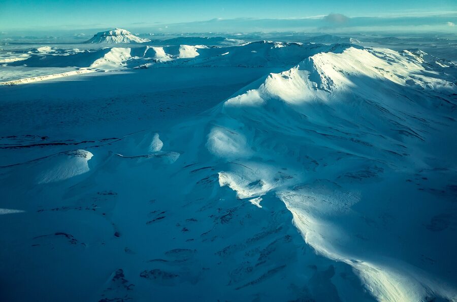
If you take a satellite photo of Iceland in late summer and look at where the green ends, what you see is a vast brown and ochre interior that has almost no roads, no farms, no towns, and barely a tree. That interior is the Highlands. It covers about 40 percent of the country, sits mostly above 400 metres, and for nine months of the year it is buried in snow with rivers no normal vehicle can cross. Then the snow retreats, the road authority opens the gates, and for roughly ten weeks a year you can drive into the strangest country in Europe. The summer guide sets up the wider season; this is the Highland-specific deep dive.
Most people who fly into Keflavík and rent a car do the Ring Road perimeter. Reykjavík, Golden Circle, south coast, glacier lagoon, maybe Snæfellsnes if they have time, then back. They never see the interior. That is fine. The Ring Road is excellent. But the Highlands are a different country and they reward the people who plan for them. Landmannalaugar with its rhyolite mountains in colours nature is not supposed to make. Þórsmörk, the green valley sandwiched between three glaciers, reachable only by 4WD over un-bridged rivers. Askja, where in 1875 a volcano exploded so violently it triggered the largest emigration wave in Icelandic history. Kerlingarfjöll, an alien geothermal cirque the locals quietly love.
This is the long version. What the Highlands actually are, how the F-roads work, when they open, how to get in if you are not driving yourself, what to do once you are there, what to skip, and the real costs in ISK. Most of the practical detail in this guide comes from doing the trips. Some of it comes from the road authority and the Iceland Touring Club, both linked at the end of each section. Treat the official sources as gospel and treat me as a friend who has done it.
In This Article
- What the Highlands actually are
- When the Highlands open and when they close
- F-roads, explained properly
- River crossings, the scary bit
- How to actually get into the Highlands
- Landmannalaugar, the rhyolite postcard
- What a day at Landmannalaugar actually looks like
- Þórsmörk, the green hidden valley
- Þórsmörk as a day trip from Reykjavík
- Askja and Kverkfjöll, the northeast Highlands
- Kerlingarfjöll, the geothermal jewel
- Sprengisandur and Kjölur, the trans-Highland crossings
- The Laugavegur trek, the classic four-day hut walk
- The Fimmvörðuháls extension
- Other Highland corners worth your time
- Hut bookings, the practical bit
- What to actually bring
- Safety, the part nobody likes
- What I would skip
- What I would actually do
- A last note
What the Highlands actually are
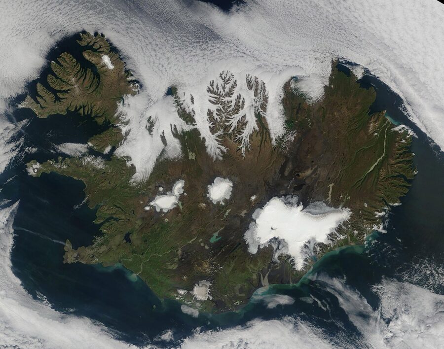
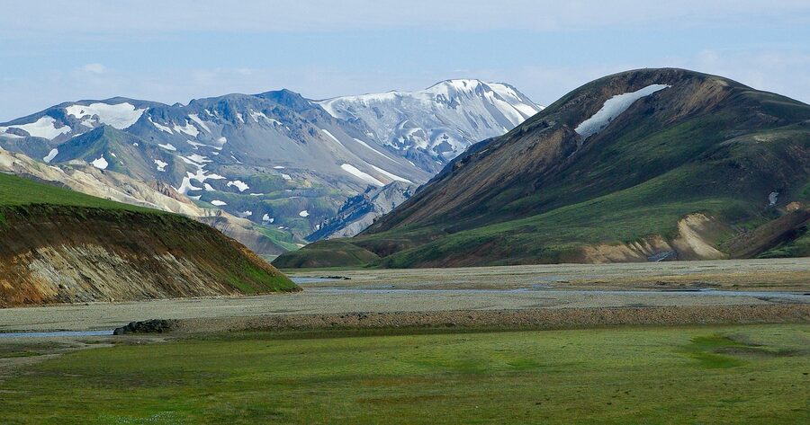
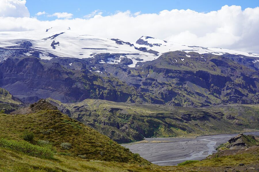
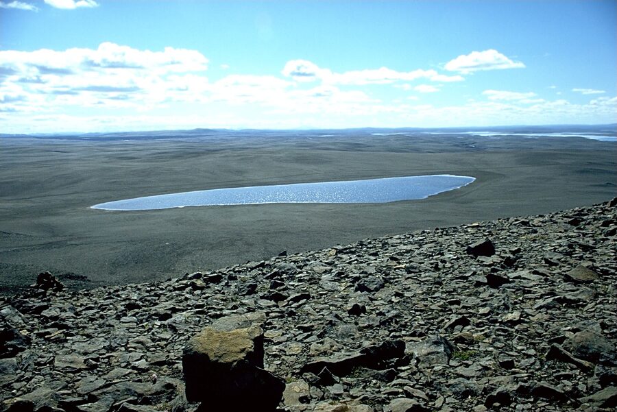
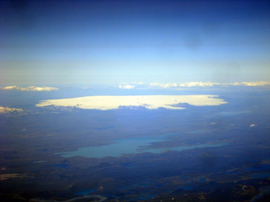
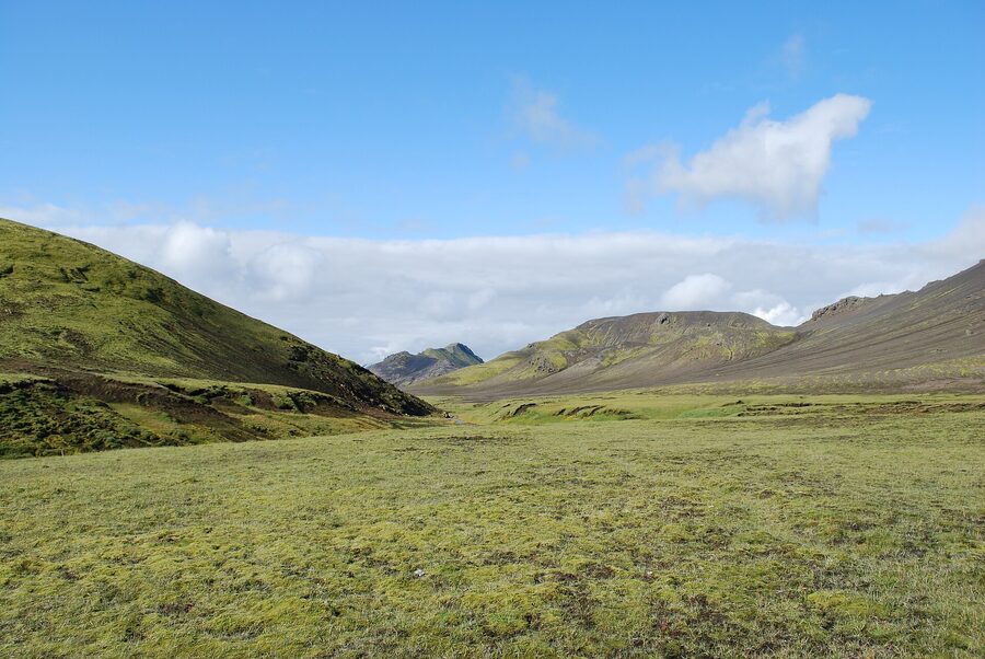
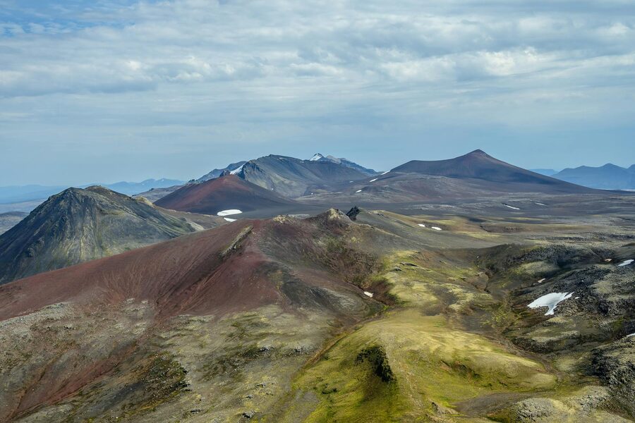
Let me start with the geography because most guides skip it. The Icelandic Highlands, what we call hálendið, is the elevated interior of the country. Roughly 40,000 square kilometres, around 40 percent of Iceland’s land area, almost zero permanent population. The defining feature is altitude. Most of it sits above 400 metres, much of it above 600. The defining geology is volcanic. The defining hydrology is glacier-fed. Vatnajökull, Europe’s largest ice cap by volume, sits inside the southeast Highlands and exports rivers in every direction. Hofsjökull and Langjökull anchor the centre. Mýrdalsjökull and Eyjafjallajökull cap the south.
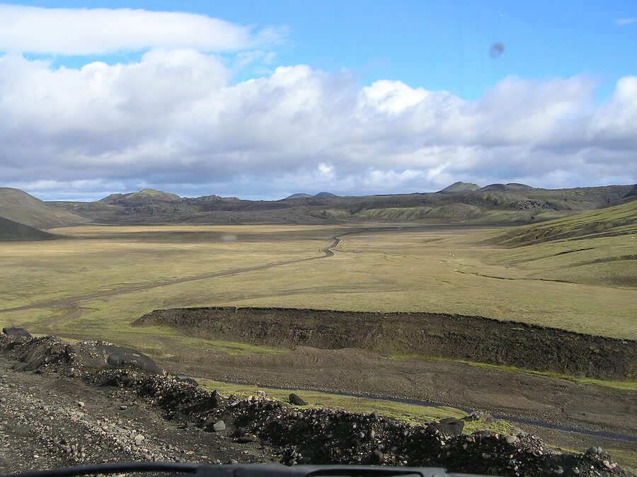
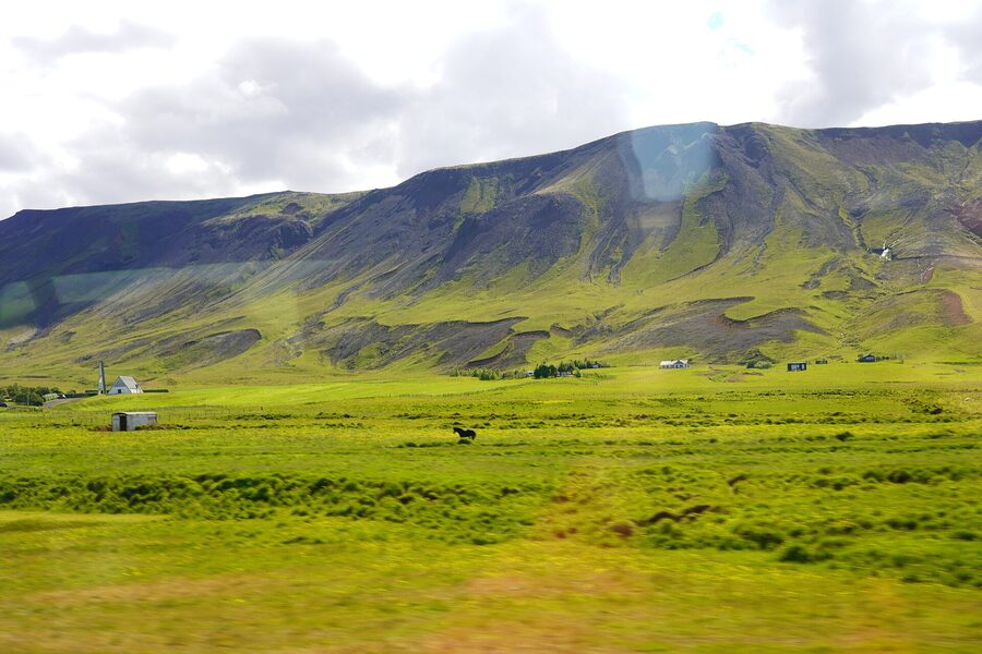
Around the perimeter there are the inhabited coasts. Inland of those, you cross a green band of pasture, then the rivers get bigger and faster, the road surface goes from asphalt to gravel, the towns end, and you are in the interior. On the maps it is the bit that does not have any roads with route numbers under 35. Inside, the road network is the F-road system. F stands for fjallvegur, mountain road. They are gravel, often single-track, frequently un-bridged across rivers, and for most of the year they are physically impassable.
The Icelandic interior is not a wasteland in the empty sense. It is full. Full of obsidian fields, hot springs, sulphur vents, fumaroles, lava flows of every age between fresh and 6,000 years old, glacier outwash plains, moss-covered nunataks, painted rhyolite hills, single-cone volcanoes, calderas the size of small cities, ice caves, alpine deserts, and the occasional improbable bright green valley where geology has tucked a microclimate. There are arctic foxes, ptarmigan, reindeer in the east, and in the high summer a handful of sheep that wandered up before the autumn round-up. Outside that, no permanent residents.
The Highlands have always sat at the edge of Icelandic life. In the medieval period the interior was a place of myth and outlaws. Útilegumenn, the outlaws, were people sentenced to skóggangur, full outlawry, for serious crimes. Banished from settled society and legally killable on sight, some of them retreated into the Highlands and lived for years in caves and remote valleys. The most famous is Fjalla-Eyvindur, the eighteenth-century outlaw who survived for two decades with his wife Halla in the geothermal patches near Herðubreið and across Sprengisandur. There is a play about him. There is a film. Every Icelander knows the story. The Highlands carry that weight even now.
For travel planning purposes, what you need to take from all this is that the Highlands are big, they are remote, they are seasonal, and they reward the people who treat them with the respect they deserve. They also contain four or five of the single most spectacular landscapes in northern Europe. If you have the days and the right vehicle or the right tour, going inland is the best decision you will make on an Iceland trip.
When the Highlands open and when they close
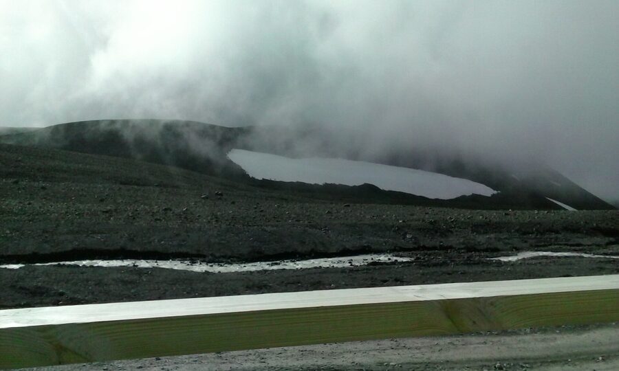
The single most important fact about the Highlands is the season. Roughly mid-June to early September. Not May. Not October. The exact dates are decided each year by the road authority, Vegagerðin, based on snow melt, river levels, and how stable the surface has become. The current map of which F-roads are open lives at road.is. It updates daily. Treat it as the only source that matters.
In a normal year the timing looks something like this. The lowest F-roads, those fringing the populated south, may open in the first half of June. F208 south to Landmannalaugar typically opens in mid to late June. The high central crossings, F35 over Kjölur and F26 over Sprengisandur, normally open from late June to the first week of July. F88 to Askja from the north, and the long approaches into Kverkfjöll, open last, often not until the first half of July. Closing dates run in reverse. The high crossings can be shut by the first proper autumn storm in mid-September. The low ones might survive into late September. After the first big snowfall it is over.
Within the season there are three sub-phases worth understanding. Late June through mid-July is the meltwater peak. Rivers run high, particularly in the afternoon when sun on the glaciers has been working all day. River crossings are at their hardest. Wildflowers and arctic flora are at their best. Daylight is at its absolute longest, the sun barely sets at all. From mid-July through August you get the most stable window. Rivers settle, the surface roads firm up, weather is statistically the most cooperative, and the routes feel manageable. Late August into the first week of September is the smart-money window if you can pick your dates. Daylight still long, weather still good, schools in many countries already back so the crowds at Landmannalaugar thin out, the rhyolite still has its summer colour. After the first storm it tips fast.
If you have flexibility, target late July or the first three weeks of August. If you want it quieter, late August into early September. If you want maximum daylight, late June. The when-to-visit guide walks every month if you want the wider context. If you are travelling outside any of those, the Highlands are not really an option, and trying to force them in October or May is how rental cars get destroyed and people get hurt.
F-roads, explained properly
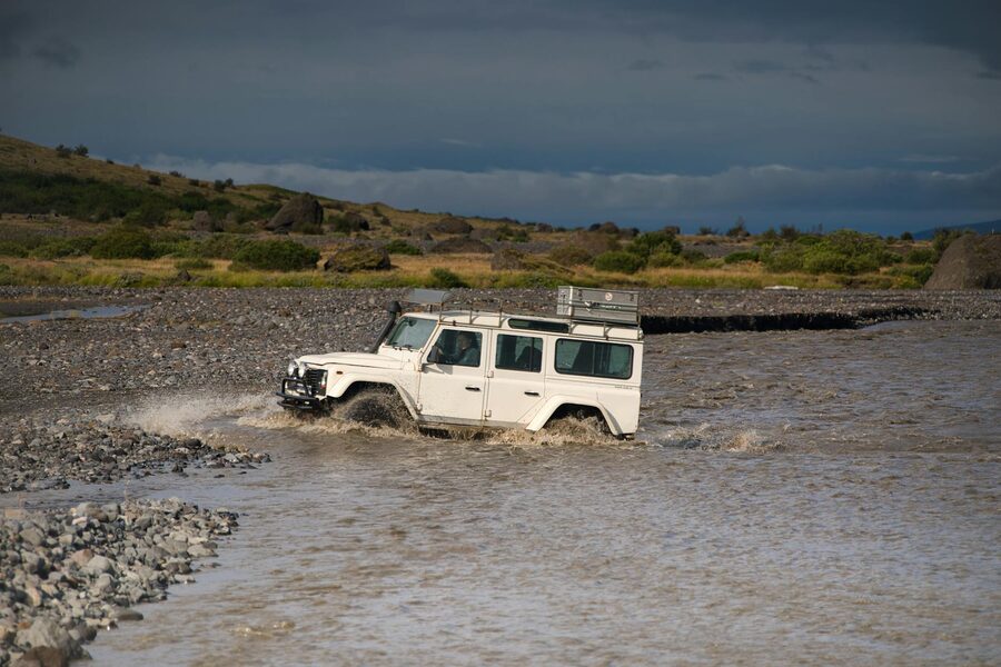
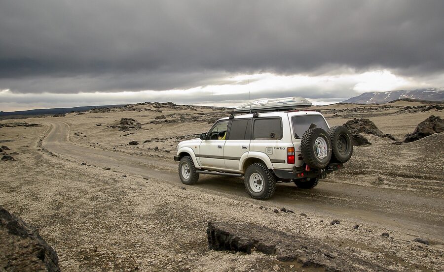
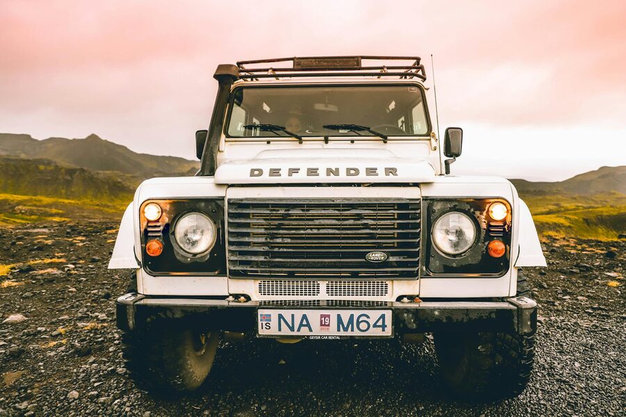
F-roads are the spine of any Highland trip and the source of most of the trouble visitors get into, so it is worth being clear about them. The F prefix on an Icelandic road number stands for fjallvegur, mountain road. Roughly 40 of them exist. They are gravel, mostly single-track, often deeply rutted, frequently include river fords with no bridge, and are by Icelandic law restricted to 4WD vehicles with appropriate ground clearance. A 2WD car, even a so-called crossover or all-wheel-drive that is not a true 4WD, is illegal on F-roads. Every rental contract in the country says so. Drive a 2WD onto an F-road and your insurance is void, you are personally liable for damage to the vehicle and to any other vehicle, and the rental company will charge you the full cost of recovery and repair. People have paid five-figure ISK invoices for ignoring this. Do not be that person.
The major F-roads worth knowing by name:
F35 (Kjölur). The central crossing between the south and Akureyri, sandwiched between the glaciers Langjökull and Hofsjökull. Around 200 km of gravel from Gullfoss to the Blönduós region. No major un-bridged rivers any more, the worst were bridged in 2010. Hveravellir, the geothermal patch in the middle, is the obvious overnight halt. Of the trans-Highland routes, Kjölur is the easiest. A Suzuki Vitara or Dacia Duster can do it in dry conditions.
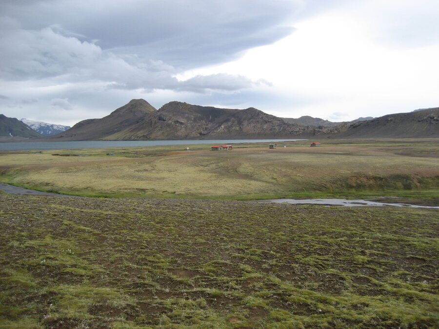
F26 (Sprengisandur). The longer central crossing, running north-south between the south coast and Akureyri, bypassing Kjölur to the east. About 250 km of largely featureless black desert between Hofsjökull and Vatnajökull. Several un-bridged rivers, two of which are serious. Highland Center Hrauneyjar at the south end and Nýidalur in the middle are the bases. The visual reward is the sheer austerity of the desert and Hofsjökull glacier in the distance. Not the most scenic crossing but the most psychologically remote.
F208 plus F26 leg into Landmannalaugar. The southern approach into the Fjallabak Nature Reserve and Landmannalaugar. F208 from the south coast at Hella runs north into the reserve and is the standard self-drive route. Several smallish river crossings, manageable in a Land Cruiser or equivalent. The northern approach via F208 from F26 is more committed. F210 across to Eldgjá is a separate leg and includes the genuinely difficult crossing of the Mýrdalssandur outwash if you continue.
F88. The route to Askja from the north, leaving the Ring Road at Mývatn region. Several deep river crossings including the Lindaá ford, which is genuinely serious. The newer F894 spur leads up to the Askja parking lot from where you walk to Víti. F88 is super-jeep territory for most rentals. If you do not have a high-clearance vehicle and significant river-crossing experience, take a tour rather than self-drive this one.
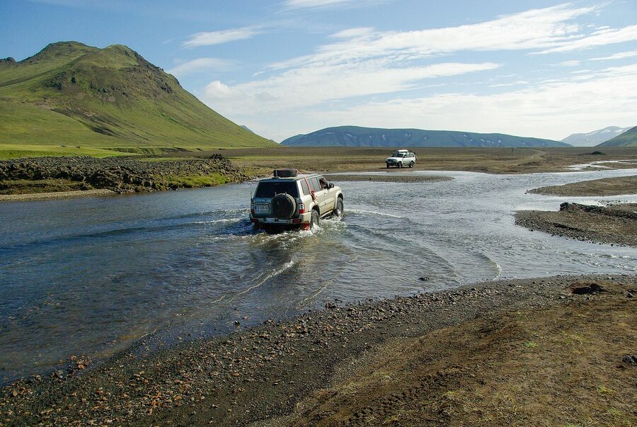
F249. The route into Þórsmörk, branching off Route 1 just east of Hvolsvöllur. Multiple un-bridged rivers including the Krossá, the famously fickle braided river that is the gateway to Þórsmörk proper. Krossá depth varies hour to hour with the glacial meltwater above. There is no rental insurance on the planet that covers a Krossá crossing. Self-drive Þórsmörk in anything other than a true super-jeep with a snorkel is a non-starter. Go by tour or by the Highland Bus.
For weather, river-level forecasts, and live road status, three sites are essential. vedur.is for the Icelandic Met Office forecast. road.is for which F-roads are physically open today. safetravel.is for safety bulletins, registering your travel plan, and the avalanche and storm advisories. Check all three the morning of any drive. They are run by serious people and they exist for good reasons.
River crossings, the scary bit
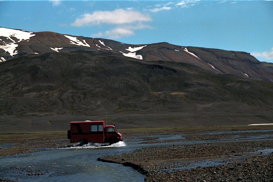
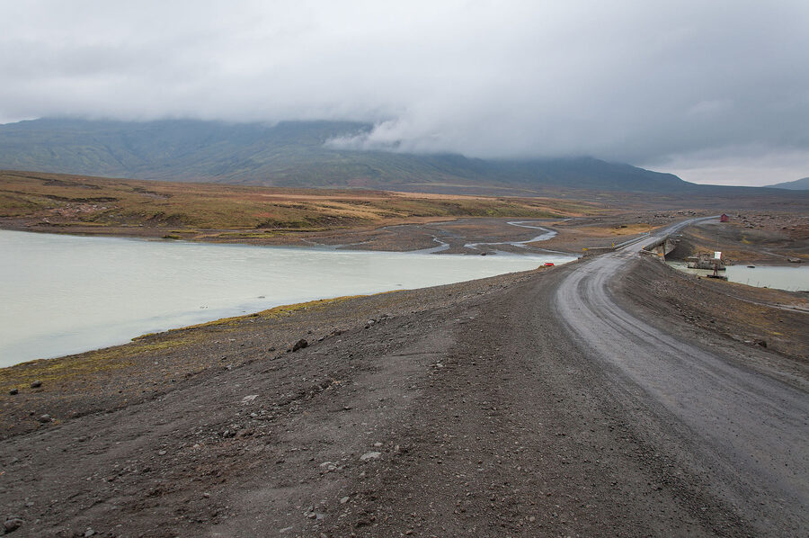
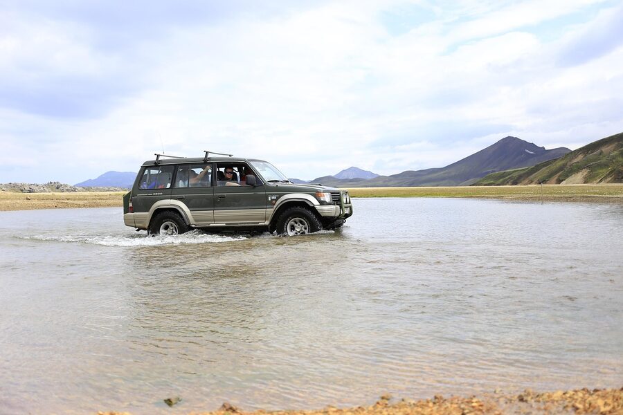
Rivers are the part of Highland driving that scares people, and they should. The country’s rental industry exists in part to repair vehicles that have been driven into rivers they should not have been. Insurance excludes water damage absolutely. If your engine swallows water and dies in the middle of a glacial ford, the bill starts at one and a half million ISK and climbs from there. So the protocol matters.
The four-rule version. First, walk it before you drive it. Get out of the vehicle, change into trousers you do not mind getting wet, and wade across at the line you intend to drive. If the water hits your knees, do not cross. If you cannot stand up against the current, do not cross. The current is what flips vehicles, not the depth. Second, drive across in low range or low gear at a steady walking pace. No stopping mid-river. No revving. Steady momentum, slight angle into the current. Third, if you are with another vehicle, cross one at a time, with the other parked on the higher bank in case you need a winch. Fourth, do not cross alone in the afternoon if you have any choice. Glacier melt peaks in the afternoon, especially in late June and early July. The same crossing that was thigh-deep at 9am can be chest-deep at 4pm.
The Water Damage Waiver, sold by every Highland-permitting rental company, does not actually cover crossing damage. Read the contract. It covers superficial water spray. It does not cover engines that drown. The rental industry’s official position is that they sell you a 4WD which is rated for crossings, and they expect you to read crossings safely. If you misread a crossing, that is on you.
If you have not done un-bridged Highland river crossings before, please do not learn on the F88 to Askja or the F249 into Þórsmörk. Take a super-jeep tour to those places. Save self-drive for F35 over Kjölur, where the major rivers are now bridged. Go to Landmannalaugar via F208 from the south, where the crossings are smaller and well-trafficked. Build the experience first.
How to actually get into the Highlands
You have four broad options for accessing the Highlands. Each has tradeoffs. I have used all of them.
Self-drive 4WD. The most flexible, the most expensive on a per-day basis, and the one with the steepest learning curve. You rent a Land Cruiser, Pajero, Defender or equivalent for around 25,000 to 35,000 ISK per day in summer, plus fuel, plus the F-road and Water Damage waivers if your operator offers them. You then drive yourself, plan your own days, sleep in huts or campsites, and live and die by your own decision-making at river crossings. northbound.is/cars compares Highland-permitting fleets across most of the major rental companies. bluecarrental.is and lavacarrental.is are two of the operators that consistently allow F-road use. Confirm in writing before you collect. Around half the Highland-going visitors I meet have made this choice and most of them have a good time, though about a third report at least one moment they would describe as character-building. The full car rental guide covers the insurance gotchas.
Super-jeep day tour from Reykjavík. The path of least resistance. A 30-something tonne lifted Mercedes Unimog or a heavily modified Land Cruiser with 38-inch tyres, run by a local outfit, picks you up at your hotel at seven in the morning and brings you back at eight in the evening, having done a day in the Highlands you could not have done in a normal vehicle. Day tours run 25,000 to 45,000 ISK per person depending on destination and group size. Operators worth looking at: Mountaineers of Iceland, Troll Expeditions, Reykjavik Excursions, and Arctic Adventures. getyourguide.com and viator.com aggregate most of these for booking. The classic single day to do is Landmannalaugar, which I will detail below.
Highland Bus to Landmannalaugar. The cheap option. Reykjavik Excursions runs scheduled summer service from Reykjavík via the BSÍ terminal to Landmannalaugar and Þórsmörk, around 7,500 to 10,000 ISK each way depending on the route. The bus is a high-clearance 4WD coach, same vehicle that handles the Krossá crossing into Þórsmörk. You can do a day return if your schedule allows or you can use the buses to access trailheads for multi-day hikes. The schedule lives at re.is. This is how the Laugavegur trekkers get in and out. It runs from roughly mid-June to early September, and the schedule tightens in September.
Multi-day super-jeep package. The committed version. Two to five days inside the Highlands, sleeping in huts or hotels, all driving and logistics handled. Operators like Hidden Iceland and Iceland Travel run bespoke packages in the 80,000 to 150,000 ISK per person per day range. These get you into the harder corners, Askja, Kverkfjöll, the full Sprengisandur. If you have a week and a budget and want the deep version, this is how to do it.
Landmannalaugar, the rhyolite postcard
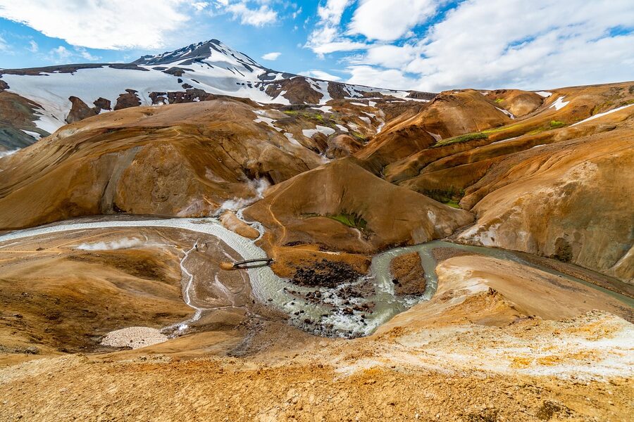
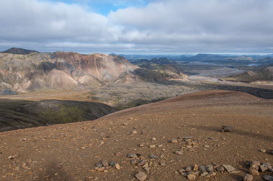
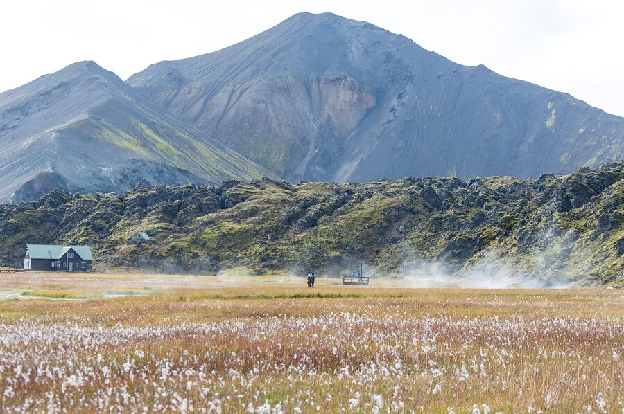
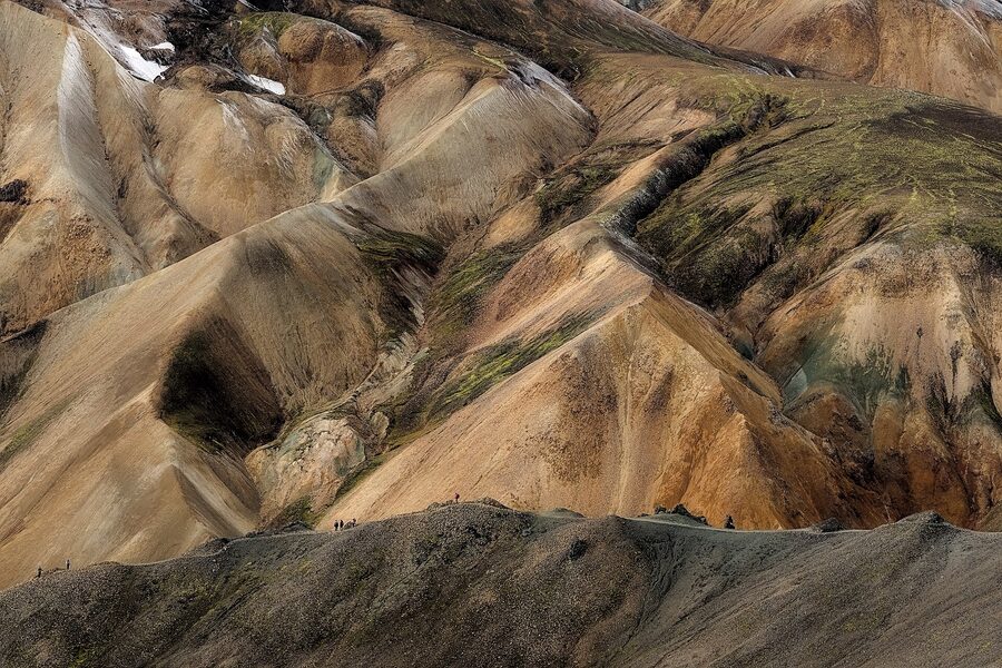
Landmannalaugar is the place every guide leads with for good reason. It is a rhyolite massif in the Fjallabak Nature Reserve, southern Highlands, with mountains in shades of orange, pink, yellow, green and grey that look airbrushed and are not. The colours come from rhyolite, the silica-rich volcanic rock that forms in slow magma eruptions, weathered and sulphured into a palette nature is not supposed to make. There is also a free hot pool at the trailhead, fed by a thermal spring mixed with cold creek water, which after a day of hiking is genuinely the best 30 ISK you will spend in Iceland (the warden’s hut sells beer and snacks for actual money, but the pool is free).
Three things you can do at Landmannalaugar inside a single visit. The Brennisteinsalda hike is the small loop, around three to four hours, taking you up the sulphur-streaked mountain on the eastern side of the basin and giving you the postcard panorama of the rhyolite valley below. This is the one to do if you have one day and one set of legs. The Bláhnúkur loop is the harder loop, about five hours with serious elevation, climbing the black peak on the south side of the basin and dropping back down through obsidian fields. The bigger view, the harder day. And the Laugavegur trail itself starts here. Day one is a substantial six-hour walk over volcanic ash to Hrafntinnusker, but you can do an hour out and back on the trail just to taste it without committing to the full four days.
The Laugar warden’s hut, the Mountain Mall, sells basic provisions, hot coffee, paid showers and WiFi. The free hot pool is open whenever there is light, which in mid-July means continuously. There is a campsite next to the parking area for tents and a hut bookable through Ferðafélag Íslands at fi.is. The hut sells out months in advance for July weekends.
Getting to Landmannalaugar self-drive: F208 from the south, Route 32 connects from Hella. A Land Cruiser or equivalent, approximately three to four hours from Reykjavík one-way. The bus from BSÍ does the run in about four hours. The standard super-jeep day tour from Reykjavík runs 25,000 to 32,000 ISK per person and is, if you ask me, the single best one-day Highland investment a first-time visitor can make in July or August.
What a day at Landmannalaugar actually looks like
If you take the super-jeep day tour, the rhythm goes like this. Pickup from your Reykjavík hotel at seven in the morning. Three hours of driving south past Hekla and onto F208, with one or two photo stops on the way as the landscape gets stranger. Arrive at the Landmannalaugar parking around 10:30. The driver will give you the lay of the land and turn you loose for four hours. Most groups split: the fitter ones do the Brennisteinsalda loop or even the harder Bláhnúkur, the more relaxed pick the small valley walk to the obsidian field and the lava labyrinth, and a few people just go straight to the hot pool with sandwiches. Lunch is on you, bring it from Reykjavík or buy at the Mountain Mall. Pickup at the parking around 14:30, three hours back, dropoff at your hotel between 19:30 and 20:30. It is a long day. It is also the day on most people’s trip they remember most clearly five years later.
Þórsmörk, the green hidden valley
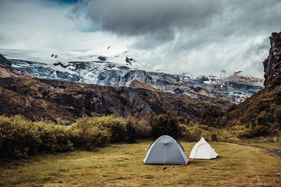
Þórsmörk, Thor’s Valley, is the green hidden valley wedged between three glaciers in the southern Highlands. Eyjafjallajökull to the southwest, Mýrdalsjökull to the south, Tindfjallajökull to the north. The river Krossá drains the lot of them and braids across the valley floor in shifting channels that change every year. Þórsmörk itself is birch and willow scrub, lush by Icelandic standards, hemmed in by black peaks and white glacier tongues. It is the only valley in the Highlands that genuinely feels green, and after a couple of days in the volcanic interior it lands like an oasis.
You cannot self-drive a normal rental car to Þórsmörk. The road in is F249, which crosses Krossá. Krossá’s depth is a function of how much it has rained in the catchment in the last 24 hours and how strongly the sun has been melting Mýrdalsjökull and Eyjafjallajökull above. It can be ankle-deep in the morning and chest-deep by afternoon. The Highland Bus and the super-jeep operators handle this with snorkels and 38-inch tyres. Your Suzuki Vitara from the airport does not. There are wrecks of Vitaras in the Krossá that will tell you the rest of the story.
Once inside Þórsmörk you are in walking country. The standard hike is the Valahnúkur viewpoint, two hours up and back, giving you the panorama of the valley with three glaciers in shot. Stakkholtsgjá canyon, three hours, is the moss-walled slot canyon that Bond would film if anyone gave him an Iceland script. The longer day is the Fimmvörðuháls extension, the eight to ten hour walk over the 2010 eruption site to Skógar, which is a serious commitment and not weather-friendly. There is also the option to do the last day of the Laugavegur trek backwards as a day hike, walking up the valley toward Emstrur.
For accommodation inside Þórsmörk, Volcano Huts Þórsmörk at Húsadalur is comfortable cabins with a restaurant, sauna and a hot tub. June to mid-September. The other option is the Ferðafélag Íslands hut at Skagfjörðsskáli, more basic, also via fi.is. Both book up a long way out for July and August. If you can only do one Highland night, this is the night to do it.
Þórsmörk as a day trip from Reykjavík
Possible and worth doing if you cannot fit a hut night. Pickup around seven, two and a half hours south on F249 with the river crossings as the highlight, two to three hours in the valley to walk Valahnúkur or Stakkholtsgjá, two and a half hours back. Operators bundle this with an Eyjafjallajökull glacier hike if you want a fuller day. The super-jeep crossing of the Krossá is reason enough to take the tour.
Askja and Kverkfjöll, the northeast Highlands
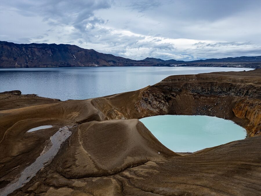
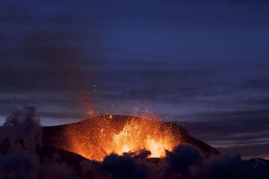
Askja sits in the northeast Highlands, at the northern edge of Vatnajökull, in a vast empty country called Ódáðahraun, the lava field of evil deeds (the name is older than tourism brochures). It is a caldera, ten kilometres across, formed in successive collapses of a much larger volcano. Inside the caldera are two lakes. Öskjuvatn is the larger and deeper, around 220 metres, formed in the 1875 eruption. Víti is smaller, milky blue, 60 metres across, sitting in a satellite explosion crater on the northeast wall of the caldera, and warm enough at 25 to 30 degrees that people swim in it.
The 1875 eruption is the historical anchor. On the night of 28-29 March 1875 the caldera collapsed and ejected an enormous tephra cloud across northeast Iceland that smothered farmland in eastern fjords with toxic ash. Whole districts lost their pasture, livestock died, farms went bankrupt. The eruption is widely credited as the trigger for the largest Icelandic emigration wave of the nineteenth century. Several thousand people left the eastern fjords for North America in the years following, founding Icelandic communities in Manitoba and North Dakota that still exist. Standing on the rim today and looking down at the caldera, knowing that, gives the place a weight nothing else in the Highlands quite matches.
Askja is currently inflating. The Icelandic Met Office at en.vedur.is has tracked steady ground uplift over the last several years and unusual seismic patterns. There is no eruption alert, but the place is not asleep. If you are visiting, check the bulletin board.
Getting in. The route is F88 from the Mývatn region in the north, branching off Route 1 east of Reykjahlíð, then F894 to the Askja parking. Several deep river crossings including the Lindaá. Six to seven hours of driving each way from the Ring Road, plus a final 45-minute walk from the parking up to Víti. This is super-jeep territory. Realistically, the way to do Askja is from a base in the Mývatn area on a day tour, or as part of a multi-day Highland package. Operators include Mountaineers of Iceland, the local Mývatn day-trip operators, and several of the bespoke multi-day outfits. Day tours from Mývatn run 25,000 to 45,000 ISK and are a 12-hour day.
Víti the swimming bit. The crater holds milky-blue mineral-rich water at 25 to 30 degrees. The descent from the rim down to the water is steep, slippery clay, and not for everyone. People do swim and people do enjoy it. People also occasionally injure themselves on the descent. There is no warden. There is no rope. Use judgement.
Kverkfjöll, further south, is the geothermal mountain on the northern edge of Vatnajökull where the ice cap meets active geothermal heat. Famous for ice caves carved by sub-glacial steam, plus high-altitude hiking through ice and steam together. Access is harder still than Askja, normally as part of a multi-day package out of either the Mývatn area or Egilsstaðir. Worth doing if you are deep into Highland trips. Skip if it is your first.
Kerlingarfjöll, the geothermal jewel
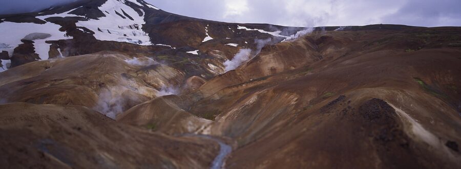
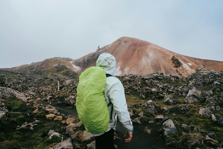
Kerlingarfjöll sits in the central Highlands roughly halfway up the F347 spur off F35 (Kjölur). It is a small mountain massif, about 1,500 metres at the highest peak Snækollur, with two main attractions for visitors. The Hveradalir geothermal area, an alpine valley laced with hot springs, fumaroles, mud pots and orange and yellow mineral colour. And the views across the Kjölur plateau, with Hofsjökull glacier dominating the eastern horizon.
Hveradalir is the showstopper. A set of marked trails through a cirque of steaming ground, with a particular knot of vents called Hverabotn at the bottom that you can walk into. The walking is moderate, with the trails set up to keep visitors away from the most fragile and dangerous ground. There are usually wardens in summer to keep an eye on people getting too close to scalding water. Two to three hours is enough to walk the main loop. A full day lets you get up onto the surrounding ridges with the Hofsjökull view.
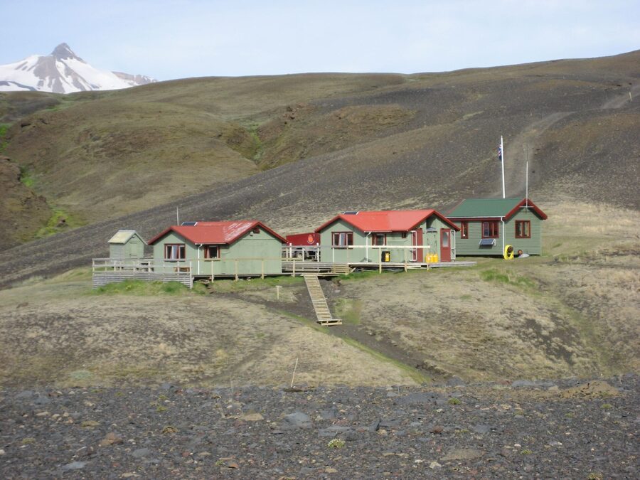
The base for Kerlingarfjöll is Highland Base Kerlingarfjöll (formerly known just as Kerlingarfjöll Mountain Resort), recently rebuilt as a higher-end lodge with rooms, hut beds, restaurant and bar. June to September. It is one of the more comfortable Highland overnights you can book and a sensible centre point if you are doing F35 across Kjölur. Booking via the operator’s site.
Self-drive access: F35 from Gullfoss is about 90 km of well-graded gravel, no major crossings since the bridging in 2010, then F347 spur up into the resort. Suzuki Vitara doable in dry conditions. Hofsjökull and Langjökull are visible most of the way and the drive is one of the more atmospheric in the Highlands. Worth doing as a self-drive even if you are not a hardcore Highland person.
Sprengisandur and Kjölur, the trans-Highland crossings
The two trans-Highland routes deserve their own section because they are the most committed F-road experiences and they are very different from each other.
Kjölur (F35) is the easier of the two. Around 200 km of gravel between the south (joining at Gullfoss) and the north (joining at Blönduós region). Bridges took out the worst river crossings in 2010, so it is now technically passable in a Vitara-grade 4WD in dry conditions. Hveravellir at the midpoint is a small geothermal area with a hut, a campsite, and a thermal pool you can swim in (small fee, reception in the hut). The route runs between Langjökull on the west and Hofsjökull on the east, with both glaciers visible for substantial stretches. A reasonably safe one-day crossing if you start early and the weather forecast is good.
Sprengisandur (F26) is the harder, longer crossing. About 250 km between the south (Highland Center Hrauneyjar at the southern end) and the north (joining the Ring Road near Akureyri). Several un-bridged rivers including the genuinely serious Tungnaá crossing in the south and the Tómasarhagi area in the middle. The visual experience is very different from Kjölur: this is true desert, mostly featureless grey-black gravel and ash, with Hofsjökull glacier in the distance and very little else. The name comes from the Icelandic verb sprengja, to burst, on the basis that horses crossing it were pushed to the limit. There is a hut at Nýidalur in the middle (Ferðafélag Íslands, fi.is, book ahead). A typical Sprengisandur crossing takes two days with the Nýidalur overnight in the middle. Super-jeep tours can do it in one long 14-hour day.
If you are choosing one trans-Highland drive, Kjölur is the safer first attempt. Sprengisandur is the more remote, more committed experience for people who already know what they are doing in Iceland.
The Laugavegur trek, the classic four-day hut walk
The Laugavegur is Iceland’s most famous multi-day trek and one of the great hut walks in northern Europe. 55 km from Landmannalaugar in the north to Þórsmörk in the south, normally walked over four days with three nights in mountain huts. The route runs through obsidian fields, rhyolite passes, glacier-fed lakes, lava fields, and a final descent into Þórsmörk along the Markarfljót valley. Day-by-day distances are roughly 12 km, 12 km, 16 km, 15 km. Total ascent is around 1,000 m, descent around 1,800 m. Open mid-June to early September with the bulk of trekkers between mid-July and mid-August.
The huts are run by Ferðafélag Íslands at fi.is. From north to south: Landmannalaugar (start), Hrafntinnusker (night one), Álftavatn (night two), Hvanngil or Botnar/Emstrur (night three), Þórsmörk (end). Hut beds run roughly 16,000 ISK per night for non-members of FÍ, slightly less for members. They are basic. Bunk beds in shared dorms, communal cooking room, no hot showers in the higher huts. They are also warm, dry, and the difference between a good trek and a hypothermia incident in the Highlands.
The booking reality is the most important thing. Hut beds for July and the first half of August sell out in the first week of October the previous year, which is when the booking system opens. If you are reading this in April for August, the high-season nights are gone. You can sometimes pick up shoulder dates (mid-June, late August) closer to the trip but for prime-season weekends, the answer was six months ago. If you missed the window, look at September dates or join a guided package, where operators reserve hut blocks. Or carry a tent and use the campsites at the huts, which do not require booking but are exposed and can be brutal in storms.
If you cannot do the full Laugavegur, the day hike alternatives are good. Bus into Landmannalaugar, walk Brennisteinsalda or do an hour out on the Laugavegur start, bus back same day. Or bus into Þórsmörk, walk Valahnúkur and Stakkholtsgjá, bus back. Two strong day hikes that bookend the trek and let you see the scenery without the four-day commitment.
The Fimmvörðuháls extension
If you are doing the Laugavegur and you want to keep walking, the Fimmvörðuháls trail extends day four from Þórsmörk over the high pass between Eyjafjallajökull and Mýrdalsjökull and down to Skógar on the south coast. The pass crosses the still-warm 2010 Eyjafjallajökull eruption site. The ground in places is genuinely warm to the touch. The trail then descends past 26 named waterfalls of the Skógá river to Skógafoss at the bottom.
It is a 25 km day with a thousand metres of climb and twelve hundred of descent, and weather conditions can change fast at the top. Most fatalities on the Laugavegur happen on this section in unexpected snow and zero visibility. If you do it, do it on a good weather day, start early, register your trip at safetravel.is, and do not be shy about turning back if conditions deteriorate. On a good day it is one of the best single-day hikes in Iceland. On a bad day it is a serious mountain expedition.
Other Highland corners worth your time
Beyond the headline destinations there are several quieter Highland places that reward the trip.
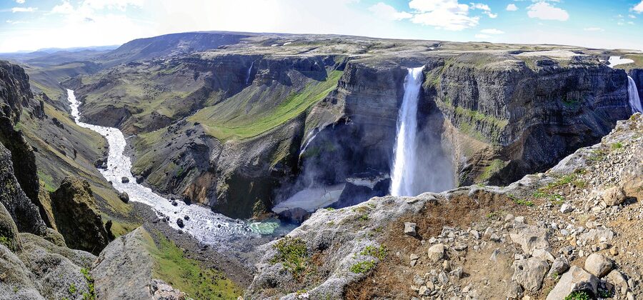
Háifoss and Granni. A pair of waterfalls in the Fossárdalur valley off F26 in the southern Highlands, roughly an hour’s gravel drive north of Hekla. Háifoss is 122 metres, the second-tallest waterfall in Iceland, plunging into a deep canyon. Granni is its smaller neighbour. The walk from the parking to the viewpoint is twenty minutes, easy. The drive in does not require an F-permit but the road is rough gravel. Great half-day stop on a Highland trip, and significantly less crowded than the Ring Road waterfalls.
Sigöldugljúfur. A canyon off F208 north of Hrauneyjar with multiple small waterfalls cascading into a green river. Easy walk from the road. Came onto the Instagram radar around 2018 and is busier than it used to be but still nothing like the south coast falls. Worth a half-day if you are doing F208 or F26 anyway.
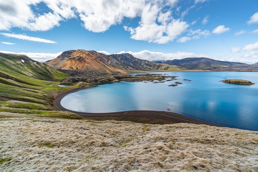
Ljótipollur. The “ugly puddle” (Icelandic understatement again), an explosion crater lake in the Landmannalaugar area, deep red walls reflected in startlingly blue water. Short detour from F208 a few kilometres north of Landmannalaugar proper. Very few visitors compared to the main basin. The 30-minute walk around the rim is easy. Bring a fishing rod if you have a permit, the lake holds trout.
Herðubreið, the Queen of Mountains. A perfect 1,682 m table mountain north of Askja, formed under an ice cap in the last glaciation, exposed when the ice retreated. Extraordinarily photogenic, distinct silhouette visible from kilometres away. Ascent is technical and not for casual hikers but the base camp at Herðubreiðarlindir, an oasis of pasture in the lava desert with hot springs and a hut, is reachable along the F88 corridor and worth the visit on the way to or from Askja. Fjalla-Eyvindur the outlaw lived in a cave near Herðubreiðarlindir for several years.
Hveravellir. The geothermal area at the midpoint of F35 over Kjölur. Hut, campsite, hot pool you can swim in for a small fee. Worth a stop on a Kjölur crossing or as a destination in itself for one or two nights.
Hut bookings, the practical bit
Most of the iconic Highland accommodations are mountain huts run by Ferðafélag Íslands. The booking site is fi.is. The booking calendar opens in early October for the following summer. By the second week of October, all the prime-summer Laugavegur hut nights are gone. Other huts (Hveravellir, Nýidalur, Askja’s Drekagil) book less aggressively and can usually be picked up two to four months ahead.
Prices broadly: Laugavegur huts around 16,000 ISK per person per night for non-members. Other huts 8,000 to 14,000 ISK. Camping at hut sites is around 2,500 to 3,500 ISK per person. FÍ membership reduces hut fees by around 30% and pays for itself if you do more than two or three nights.
If you missed the FÍ booking window, look at Volcano Huts Þórsmörk for cabin or hut beds (booking direct), landmannahellir.is for the alternative Landmannalaugar-area hut at Landmannahellir (private operator), Highland Center Hrauneyjar for the southern Sprengisandur base, or Highland Base Kerlingarfjöll for the central Highlands lodge. These are all bookable independent of FÍ and typically have summer availability if you book three to four months ahead.
What to actually bring
The Highlands punish people who pack for a city break. The list below is what you actually need for a day trip or short overnight. For a multi-day trek, scale up and check the FÍ packing list.
Hiking boots, broken in, waterproof, with ankle support. The terrain is rocky and uneven, hot springs and rivers will mean wet feet, the boots have to handle both. Trail shoes are not enough for the Highlands.
Layers. Merino base layer, mid-layer fleece or synthetic, waterproof and windproof shell. The wind, not the temperature, is what makes Iceland’s Highland weather hostile. A 10°C day in still air is pleasant. A 10°C day in a 50 km/h wind with horizontal rain is hypothermia weather inside an hour without proper shells.
Gloves and a hat, even in July. Especially at the higher elevations. The wind-chill is real.
Backpack with capacity for four to five litres of water per person, plus lunch, plus the layers you are not currently wearing. If you are walking for the day, bring more water than you think you need. Stream water is technically clean in the Highlands but glacial run-off carries silt that tears up your stomach.
Sun cream and sunglasses. UV is intense at altitude and snow and ice reflect it back at you. Many of the worst Highland sunburns happen on overcast days when people did not feel like they needed protection.
Insect repellent. The Mývatn area especially has mayfly clouds in summer that are genuinely difficult. Ask anyone who has been.
Offline maps. Cell coverage in the Highlands ranges from patchy to nonexistent. Download maps.is regions for offline use, or use the Maps.me app with downloaded Iceland data. A paper map of Fjallabak and the Þórsmörk area is also worth having. Vegagerðin and most book shops in Reykjavík sell them.
Headlamp. Yes, it is light all night in July, but if you are in a hut or out in fog it matters.
Cash and card. Most places take card now, including the warden’s hut at Landmannalaugar, but card readers in the Highlands fail all the time and cash is the backup.
Safety, the part nobody likes
The Highlands are not dangerous in any vindictive sense, but they are unforgiving of bad decisions. A handful of people die in the Icelandic interior every year. Most of them are in vehicles that should not be where they are, or on hikes in weather they should not be in. The protocol is simple and worth saying clearly.
Register your trip at safetravel.is. The site lets you log your route and dates so search and rescue have a starting point if you do not check in. There is no fee. It takes five minutes. Do it for any multi-day Highland trip.
Check the weather and road status the morning of any drive. Vedur.is and road.is. If road.is says the road is closed, the road is closed, and the closure is enforced by the surface itself, not a sign that can be ignored. If vedur.is shows a yellow or orange wind warning, take it seriously.
Tell someone your route and your expected return time. Hotel staff in Reykjavík will hold a note for you. Friends and family at home are fine but they need a window so they know when to start worrying. If you are travelling with a hire vehicle, the rental company will accept a route plan deposit too.
Do not push through bad weather. Glacial valleys can hold weather that is much worse than the forecast for the nearest inhabited point. If conditions deteriorate, sit it out at a hut, in your vehicle, or turn back. The mountain will be there next year.
Carry emergency rations. A spare day’s food and water in the vehicle, plus an emergency space blanket and a first-aid kit. The Iceland Search and Rescue (ICE-SAR) volunteers do extraordinary work, but the closest team can be hours away from any Highland location.
Glacial rivers, again, will kill you if you misjudge them. The protocol from the river-crossings section above is not optional. Walk before you drive. Do not cross at the deepest point. Do not cross alone in the afternoon if you can avoid it.
What I would skip
Three categories of Highland mistake I see often enough to warn about specifically.
Two-wheel-drive cars on F-roads. Already covered. Genuinely illegal, voids insurance, the hire company will charge you the full repair, and people get killed in the Krossá doing this. There is no version of this where it works out. The full car rental guide explains exactly which categories of vehicle you actually need and which insurances are worth paying for.
Late September and early May “shoulder season” Highland trips. Conditions are wildly unstable. Roads close on no notice. You can drive eight hours to find a road locked at the gate. Cancellation rates on tours in those windows run 30 to 40 percent. If you have only those dates available, do a coastal trip and skip the Highlands. Come back in summer.
The most expensive multi-day super-jeep package when a day tour gives you a good taste. Several outfits sell five-day Highland circuits at 600,000 to 800,000 ISK per person. They are excellent, but unless you are deep into Iceland already and want the full immersion, two well-chosen day tours, one to Landmannalaugar and one to Þórsmörk, will give you 70 percent of the experience for 15 percent of the money. Spend the difference on an extra night at Mývatn or two days in the Westfjords.
What I would actually do
For most first-time visitors with a one- to two-week summer Iceland trip, here is the version I would suggest. The day tours guide covers the wider catalogue from Reykjavík; the photo tour piece covers the photographer-led versions of these Highland trips. For bespoke routing, the customized tours page is the entry point. Pure Highland-only: Book one super-jeep day tour from Reykjavík to Landmannalaugar in late July or early August, around 28,000 to 32,000 ISK per person. Book a second day tour to Þórsmörk separately, around 25,000 to 32,000 ISK. Do both at the start of your trip while you have energy, then run the Ring Road or south coast in your rental for the rest of the trip. Total Highland investment around 55,000 to 65,000 ISK per person, two long days, two of the best memories of the trip.
For the slightly more committed visitor, add an overnight at Volcano Huts Þórsmörk (book six months ahead) and walk Valahnúkur and Stakkholtsgjá in a leisurely day and a half rather than a rush. Or rent a 4WD and self-drive Kjölur (F35) over two days, with a Hveravellir overnight. Both of these add a real Highland night without committing to the trekking calendar.
For the serious outdoor visitor with a week to spend and the planning lead time, the answer is the four-day Laugavegur with FÍ huts booked in October the previous year. Bus in to Landmannalaugar from BSÍ, walk to Þórsmörk, bus back, total cost around 80,000 to 100,000 ISK including transfers, hut beds and food. This is the trip that gets people coming back to Iceland for the third and fourth times.
For the very serious, the multi-day super-jeep package to Askja and Kverkfjöll, or a self-drive Sprengisandur in your own Defender. Both demand real commitment. Both are extraordinary if you have the time and the budget and the backbone for them. Talk to the operators on the tour categories page if you want to compare specific packages, or browse the destinations archive for context on the regions the Highlands touch.
A last note
The Highlands are the secret most Iceland visitors never get into. The Fire and Ice tour piece covers the volcano-and-glacier overlay (Askja, Þórsmörk and Eyjafjallajökull are all in here) and the first-timer guide sits at the top of the tree. The Ring Road is wonderful and there is no shame in skipping the interior on a first trip. But if you have a chance, even a single day, take it. There is nothing in Europe that looks like Landmannalaugar. There is nowhere on the continent like Þórsmörk. The 1875 history at Askja is the kind of thing you can only feel by standing on the rim. The geothermal valley at Hveradalir is genuinely otherworldly. Þetta reddast, as we say. It will work out. Plan well, respect the rivers and the weather, listen to the road authority, and go.
For the season just before you arrive, check vedur.is, road.is and safetravel.is. For huts, fi.is for the Ferðafélag huts and the operators above for everything else. For tours, the day operators in Reykjavík run from mid-June to early September. The interior is open. Þetta er hálendið. This is the Highlands.