If you only get one day outside Reykjavik, this is the one. Route 1 east of the city, the South Coast, is where Iceland tries to show off everything it has in a single 480 km strip. Waterfalls you can walk behind. A glacier tongue you can stand a few metres from. A black-sand beach with sea stacks the trolls forgot to bring home before sunrise. And the further east you push, the bigger the ice gets, until you’re standing at Jökulsárlón watching icebergs the size of vans drift toward the sea.
I’ve driven this stretch in every season, in every kind of light, in winds that tried to take the car door off and on still mornings when the surface of the glacier lagoon looked painted. What follows is how I’d actually do it, what’s worth the stop, what’s overrated, and the one safety warning that I would tattoo on every tourist’s forearm if they’d let me.
In This Article
- What people mean by “the South Coast”
- How long do you need
- The drive out: Reykjavik to Hvolsvöllur
- Seljalandsfoss and its hidden neighbour
- Skógafoss and the 527 steps
- The DC-3 plane wreck on Sólheimasandur
- Sólheimajökull: the easy glacier
- Dyrhólaey: arch, puffins, lighthouse
- Reynisfjara: the warning that has to come first
- Vík: the small base east of the waterfalls
- Where to stay in Vík
- Where to eat in Vík
- The drive east of Vík: lava fields and emptiness
- Skaftafell and Svartifoss
- Jökulsárlón: the lagoon that keeps producing icebergs
- Diamond Beach: the icebergs come ashore
- Höfn: langoustine, ice cap, end of the line
- Getting there: drive, bus, or guided tour
- Self-drive
- Bus tours from Reykjavik
- Multi-day organised trips
- When to go
- Summer (June to August)
- Winter (November to March)
- Shoulder seasons (April–May, September–October)
- Activities to add along the route
- What it costs
- What I’d actually do
- What to skip if you’re tight on time
- One last thing about the weather
What people mean by “the South Coast”
When Icelanders or tour operators say Suðurströnd, the South Coast, they mean Route 1 from Reykjavik east, roughly as far as Höfn. The official length you’ll see on operator websites is about 480 km from Reykjavik to Höfn. Most day tours stop at Vík (190 km out, 380 km round trip) and turn back. Two- or three-day trips push further to Skaftafell, Jökulsárlón, and Höfn at the eastern end. Beyond Höfn you’re into the East Fjords, which is a different trip entirely, quieter, slower, prettier in a low-key way, but not what you came south for.
The route stitches together the country’s greatest hits. Waterfalls. A black-sand beach. A glacier tongue. A glacier lagoon. Iceland’s largest national park. Lava fields old enough to have moss the depth of a mattress. A small fishing town that produced one of Halldór Laxness’s sharpest novels (Salka Valka, set in a thinly disguised Höfn). It’s not a hidden corner of the country. Most of these stops are on the front of every Iceland brochure ever printed. They’re popular because they’re genuinely good.
How long do you need
The South Coast is one of the rare bits of Iceland that scales nicely. Pick the version that fits your time and your tolerance for sitting in a car.
One day from Reykjavik (10–12 hours): Reykjavik → Seljalandsfoss → Skógafoss → Reynisfjara → Vík → back to Reykjavik. About 380 km round trip. You’ll see the big waterfalls and the black-sand beach, eat a quick dinner in Vík, and roll back into the city around 8 or 9pm. Tight, but doable. This is what every bus tour does.
Two days with a Vík overnight (the version I recommend): Day 1 is the same, except you sleep in Vík. Day 2 you push east, Sólheimajökull glacier walk, Skaftafell hike, Jökulsárlón, Diamond Beach, then the long drive back to Reykjavik (about 4.5 hours from Jökulsárlón). It’s still a hard Day 2, but you’ve spread the load and you’ve actually seen the eastern half.
Three days to Höfn and back: Day 1 Reykjavik to Vík via the classic stops. Day 2 Vík east to Höfn via Skaftafell and Jökulsárlón. Day 3 Höfn area in the morning (langoustine for lunch is mandatory) and the long drive back to Reykjavik. About 970 km of driving across three days. This is where you start to enjoy the route instead of fighting it.
One-week Ring Road extension: If you’ve got a full week, the South Coast is your first three days. After Höfn you continue clockwise around Iceland on Route 1, past the East Fjords, Mývatn, and Akureyri, back through the Westfjords or straight south. We’ve got a separate guide for that, see the Ring Road itinerary for the full circle.
The drive out: Reykjavik to Hvolsvöllur
You start by climbing over the Hellisheiði pass, which tops out at about 370 metres. On the right you’ll see Hellisheiðarvirkjun, the geothermal power plant that supplies most of Reykjavik’s hot water. The visitor centre is open daily and worth 30 minutes if you want to see what an Icelandic kettle looks like at industrial scale (and learn why your hotel shower smells faintly of sulphur). It’s free for the exhibition area, around 1,800 ISK for the guided plant tour.
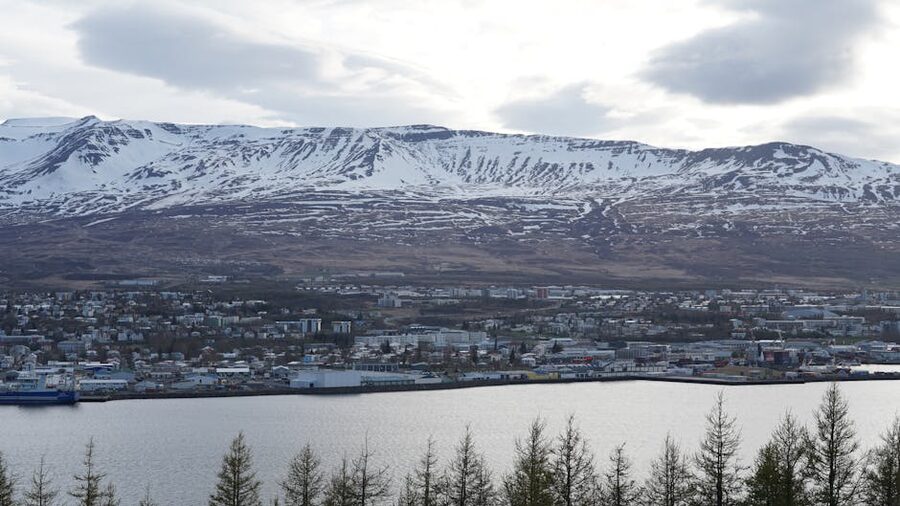
Down the other side you’ll roll into Selfoss, the biggest town in southern Iceland with about 9,000 people. It’s where Bobby Fischer is buried, in the small Laugardælir church cemetery five minutes east of town. He moved here after Iceland granted him citizenship in 2005 and died the next year. The grave is signposted from the road and there’s no fee to visit. Most tour buses skip it; if you’ve got a chess habit, it’s a pleasant 10-minute detour.
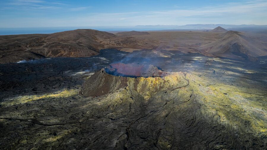
From Selfoss it’s about 35 minutes east to Hvolsvöllur, a one-street town that punches above its weight thanks to the Lava Centre. Open 9–7 in summer, slightly shorter winter hours, around 4,500 ISK for adults. It’s the best volcano museum in the country, interactive, well-paced, an hour and a half if you read everything. Worth doing on Day 1 because everything you’ll see east of here makes more sense once you understand the geology underneath it.
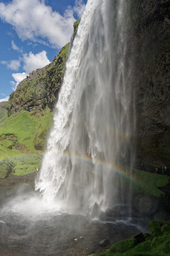
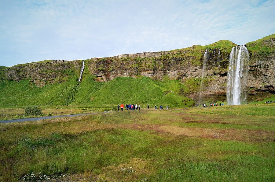
Seljalandsfoss and its hidden neighbour
Twenty-five minutes east of Hvolsvöllur, you’ll see it before you see the sign. Seljalandsfoss is a 60-metre drop where the river Seljalandsá flies off a sea cliff that the ocean abandoned at the end of the last ice age. What makes it famous is the path that loops behind the waterfall, there’s a hollow in the cliff face wide enough for a single-file walk through.
The car park costs 800 ISK (pay at the machine, card only, there’s no cash booth). It’s busy in summer between 10 and 4, and uncomfortably busy on cruise-ship days. Get there before 9am or after 6pm if you can. The behind-the-falls path is slippery year-round and properly dangerous in winter when ice forms, the rangers usually rope it off then. Wear waterproof everything; you’ll get wet whether the wind cooperates or not.
Now the part most day tours miss. Walk 500 metres north from the main car park, past the smaller falls, and you’ll come to Gljúfrabúi, the “canyon dweller.” It’s a waterfall hidden inside a slot canyon. To see it you wade or stone-hop up a shallow stream into a rocky cleft and emerge into a cathedral-shaped chamber with the water roaring down from above. It’s one of those places where the photo doesn’t work and the experience does. Free, no fee, almost always quieter than its big sibling next door.
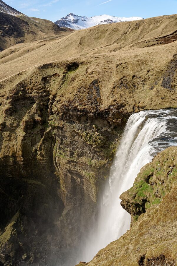
Skógafoss and the 527 steps
Half an hour further east, Route 1 rounds a bend and Skógafoss appears straight ahead, a 62-metre block of white water. It’s the same geological story as Seljalandsfoss, water tumbling off the old sea cliff, but Skógafoss is wider, louder, and you cannot walk behind it. What you can do is climb. There are 527 metal steps on the right side of the falls (yes, I counted, twice, because I lost track once). At the top there’s a viewing platform, and beyond that the Fimmvörðuháls hiking trail keeps going for 25 km past 26 more named waterfalls into Þórsmörk.
The base of the falls is free, the car park is free (rare on this coast), and the spray on a windy day will cover you in seconds. Rainbow forms in the afternoon when the sun is behind you. Don’t waste the climb if it’s drizzling, the view from the top is mostly cloud.
The local legend goes that the Viking settler Þrasi Þórólfsson buried a chest of gold under the falls. A boy once tried to drag it out with a rope, only managed to grab a ring on the side, and the ring went on to become the door handle of Skógar church, where it stayed for centuries. It’s apparently in the small church museum now if you want to test your faith in folklore.
Right next to the waterfall is the Skógar Folk Museum, an open-air collection of turf houses, fishing boats, and farm buildings that have been moved here from across the south. The grounds are free; indoor exhibits are around 2,500 ISK. If you’ve never seen the inside of a turf house, low ceilings, wood-panelled rooms heated by a single peat fire, a smell I cannot describe but never forget, it’s worth the stop. This is how almost every Icelander lived until the 1920s.
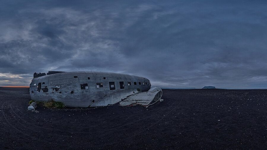
The DC-3 plane wreck on Sólheimasandur
Eight kilometres further east, watch for the small parking area on the south side of Route 1 marked “Sólheimasandur Plane Wreck.” A US Navy DC-3 belly-landed on the black sand here in 1973 (everyone walked away, they ran out of fuel after icing up). The fuselage has been sitting there ever since.
To reach it you walk 4 km out across flat black sand. There’s a shuttle bus from the car park (around 4,000 ISK round trip) if you don’t fancy the 8 km round walk. I’d skip both unless you really want the photo. There’s no shelter, no benches, no signs along the way, and on a bad-weather day it’s miserable. On a clear day it’s the most photogenic abandoned aircraft you’ll ever see, and you’ll have to share it with thirty strangers all queuing for the same shot.
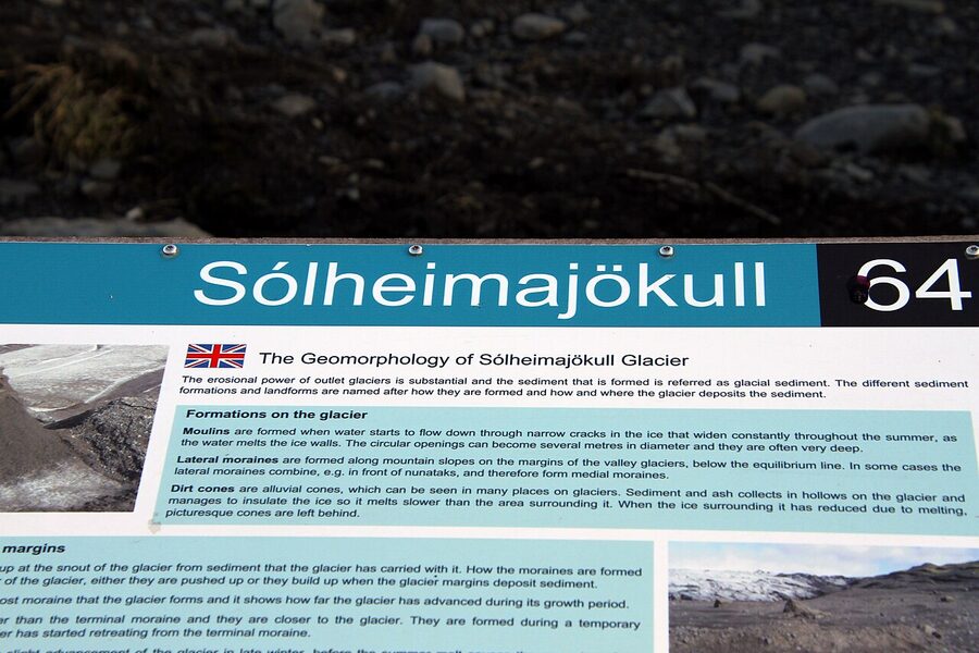
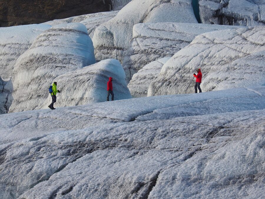
Sólheimajökull: the easy glacier
A few minutes past the plane-wreck car park, a small road heads inland to the Sólheimajökull glacier tongue. It’s the most accessible glacier on the South Coast, a 1 km flat walk from the car park brings you to a viewing area at the foot of the ice. Free, open year-round, no booking needed for the walk itself.
If you want to actually walk on the glacier, you need a guide and crampons. Icelandic Mountain Guides and Arctic Adventures both run small-group hikes from the car park, three to four hours, around 13,000–18,000 ISK. They supply the gear. Don’t try to walk on the ice solo, Sólheimajökull is riddled with crevasses and meltwater channels you can’t see until you’re in one. Two people died here in 2017 doing exactly that.
Sólheimajökull has retreated more than 1 km since 2000. The glaciologists at the University of Iceland have a measurement post at the snout that gets moved every couple of years. Standing there and looking at the photo board showing where the ice was in 1995 is the most affecting thing on the South Coast for me. It’s not a tourist attraction; it’s a slow disaster you can stand in front of.
For the full glacier-day version of this stop, our Iceland glacier hike guide has the operator comparison and what to wear; the glaciers and geysers page covers the broader pillar.
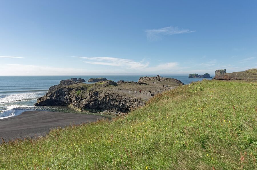
Dyrhólaey: arch, puffins, lighthouse
Just before Vík, a side road climbs up to the Dyrhólaey peninsula, a 120-metre headland with a basalt sea arch, a small lighthouse, and a colony of Atlantic puffins that nest May through August. The view is enormous: Reynisfjara below to the east, the Mýrdalsjökull glacier behind, and the open North Atlantic stretching as far as the curvature lets you see.
The road up is closed every spring during the puffin nesting season (usually 1 May to 25 June, though dates shift annually based on bird arrivals). Check before you go. The lower viewing area stays open year-round. There’s no entry fee.
Two practical notes. The road is single-lane, gravel, and steeper than it looks, drive in low gear in winter, and don’t take a campervan up unless you’re confident reversing it. And the wind on top of Dyrhólaey can be aggressive. I’ve been knocked off my feet there twice; one of those times I ended up sitting down in the gravel until it eased off. Hold onto kids and don’t approach the cliff edge.
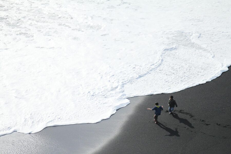
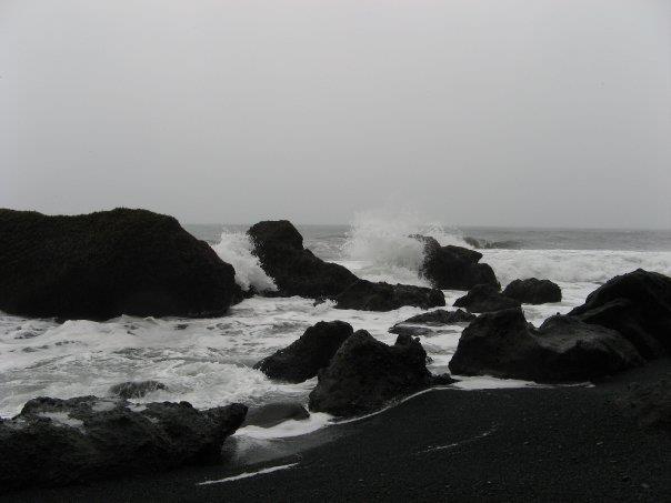
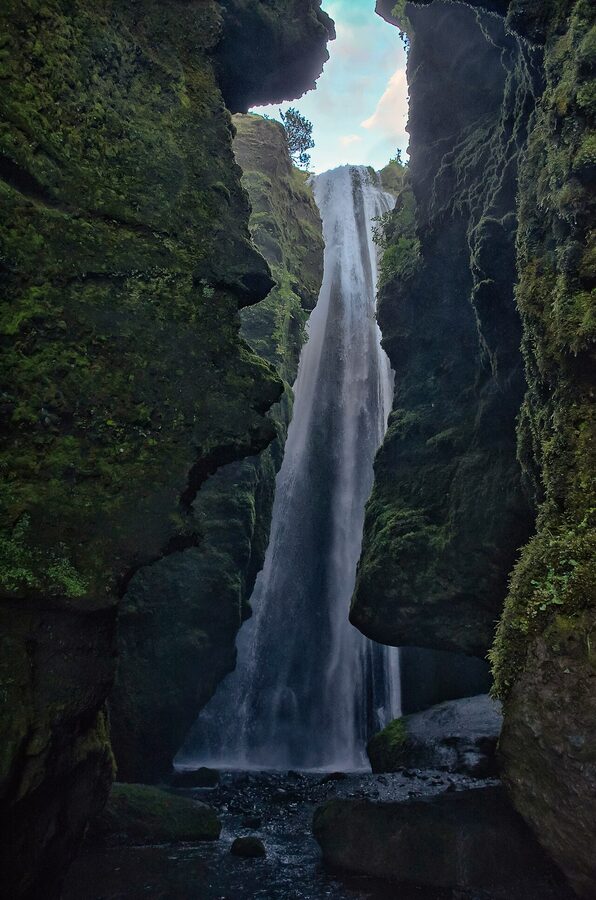
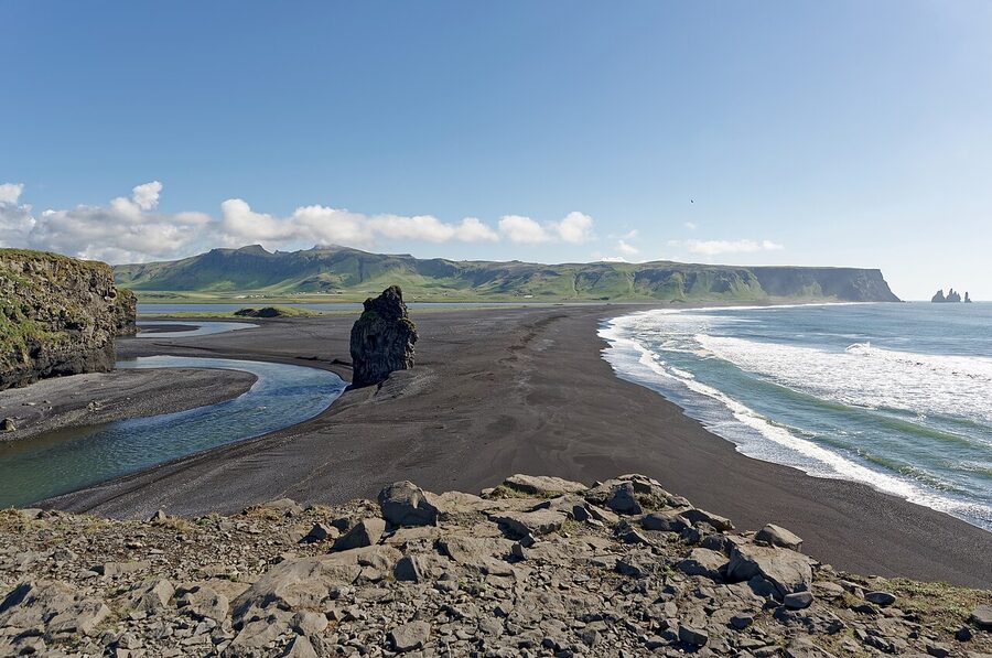
Reynisfjara: the warning that has to come first
Before I tell you anything about Reynisfjara, the famous black-sand beach, read this paragraph twice.
People die here. Not “have died, once, decades ago”, people die here regularly. Five fatalities between 2007 and 2024, a sixth in August 2025 when a 9-year-old girl drowned after sneaker waves caught her family in the basalt-column cave. The waves are called sneaker waves because they appear without warning, sometimes 30 metres further up the beach than the previous wave reached, and they pull people back into freezing water with currents you cannot swim against. The water comes from the Southern Ocean with nothing in between to slow it down. There is no way to predict which wave will be the dangerous one.
The rules, every single one of which has been broken by someone who later got rescued or didn’t:
- Never turn your back on the sea. Not for a photo. Not for a second.
- Stay at least 30 metres from the waterline. Closer than that and you’re inside the danger zone.
- Watch the warning lights. The beach has a flashing-light system installed in 2022, green, yellow, red. If it’s red, do not go down to the sand. After the 2025 death, the council also closes off the basalt-column cave when the red light is on.
- Do not enter Hálsanefshellir cave when waves are running. The cave is the photogenic one with the columns; it is also where the most dangerous trapping happens.
I’m sorry to lead with this. Reynisfjara is genuinely one of the most beautiful beaches in the country and I’d hate for you to skip it. But it’s not a beach in the way you’re used to. It’s a piece of geology that happens to look like a beach.
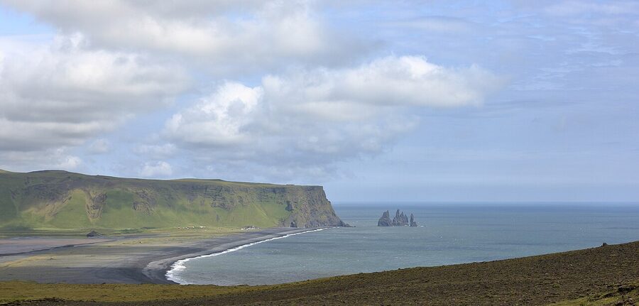
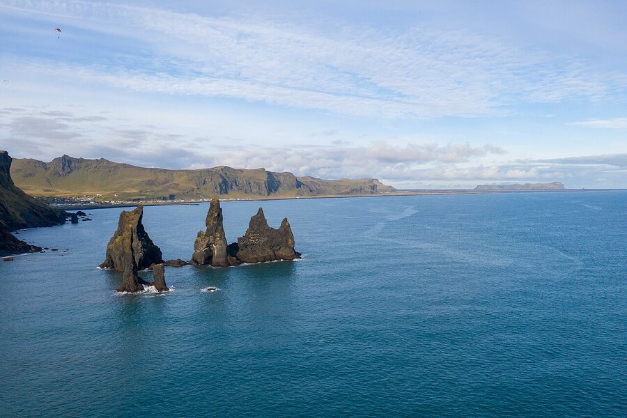
Now, the beach itself. The sand is volcanic, ground from basalt by the surf into a fine glittery black. The cliff at the eastern end is hexagonal basalt columns, the same geological pattern as the Giant’s Causeway in Ireland or Devil’s Postpile in California; cool magma cracking into honeycomb shapes as it shrinks. The sea stacks just offshore are Reynisdrangar, three jagged spikes that, in the folklore, are two trolls who tried to drag a three-masted ship to land overnight and got caught by the sunrise. They’ve been petrified ever since.
Note: in February 2026, weeks of east winds and heavy surf collapsed part of the basalt columns and reshaped a chunk of the beach. The rangers have re-marked the safe zones since. Check current conditions on safetravel.is before you visit.
Vík: the small base east of the waterfalls
Vík í Mýrdal, usually just Vík, is a town of about 800 people that punches well above its weight as the South Coast’s overnight base. There’s one petrol station (the N1 on Route 1), one supermarket (Krónan, open until 8pm), one wool shop (Víkurprjón, the only thing in town that ships internationally), and a striking white church on the hill that you’ll see in every Vík photograph because it’s the only thing higher than the buildings.
From Vík you can see the Mýrdalsjökull glacier, which sits on top of the Katla volcano, which is overdue for an eruption that nobody is in a hurry to witness up close. The 2010 Eyjafjallajökull eruption that grounded European air travel for a week was Katla’s smaller neighbour to the west. When Katla goes, and the geologists say when, not if, Vík is the town that gets evacuated. They run the drill every year.
Where to stay in Vík
I have a soft spot for Hotel Vík í Mýrdal, central, quiet rooms, the breakfast buffet has skyr and lamb sausage, and the staff actually live here. About 35,000–55,000 ISK depending on season.
Black Beach Suites sits a couple of kilometres west of town with views straight at Reynisdrangar. Nicely designed apartments, kitchenettes, the windows are the point. Around 50,000–80,000 ISK.
Magma Hotel is 20 minutes east of Vík at Kirkjubæjarklaustur, set among the Eldhraun lava field. Standalone wooden cabins on a small lake, Northern Lights views in winter, very quiet. Easily 70,000–100,000 ISK in peak season but worth every krona on a clear winter night.
If those are full, also look at Volcano Hotel further east, or any of the smaller guesthouses on Booking with Vík in the title. Book ahead in summer, there are not many beds in town and they sell out by April for July and August.
Where to eat in Vík
Halldórskaffi on the main street is the locals’ lunch spot, named after the ferryman who used to row passengers across the river before the bridge. Lamb soup (around 2,800 ISK), pizza (around 3,500 ISK), the cake counter is good. Open 11.30 till about 9pm.
Suður-Vík is the dinner upgrade. Set in a wooden house with a fireplace, the menu does Icelandic mains with French technique, the Arctic char and the lamb shank are reliably good, mains 4,500–7,500 ISK. Book ahead in summer; it’s small.
Berg Restaurant inside Hotel Vík is a fine fallback if the others are full. Solid breakfast for non-guests (around 3,500 ISK), and an evening menu of fish soup, lamb, char.
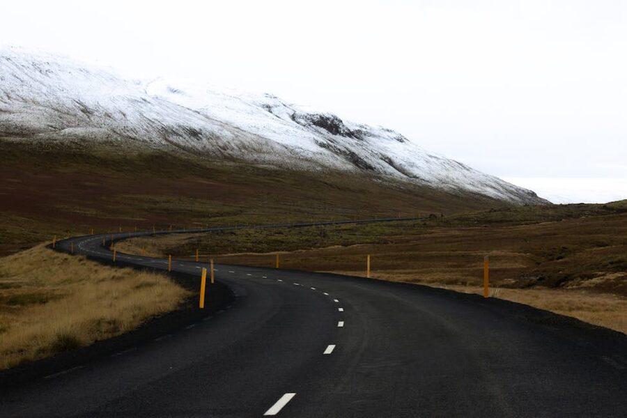
The drive east of Vík: lava fields and emptiness
The next hour east is one of my favourite drives in Iceland and the one most tour buses skip. Twenty minutes past Vík, Route 1 cuts through Eldhraun, the lava field from the Laki eruption of 1783, which lasted eight months, killed about a quarter of Iceland’s population through the famine that followed (the “Mist Hardships”), and is generally considered one of the worst environmental disasters in European history. The lava flowed across 565 square kilometres. It’s still here, covered in a thick green moss that takes about 70 years to grow back over volcanic rock and gets crushed by a single footprint.
Stop at one of the small lay-bys along the way. Don’t walk on the moss. Just look at it, the colour is genuinely unreal in afternoon light, somewhere between sage and chartreuse, soft as a duvet. There’s a small viewing platform near the village of Kirkjubæjarklaustur (you don’t need to know how to pronounce it) with information boards.
Past Eldhraun the road runs along the southern edge of Vatnajökull, the largest glacier in Europe by volume. You’ll catch glimpses of ice tongues in the gaps between mountains. The wind here can be vicious, Route 1 between Vík and Skaftafell is the stretch most likely to be closed in winter for sandstorms (yes, sandstorms, the wind picks up volcanic ash from the glacial outwash plains). Check road.is before you set off.
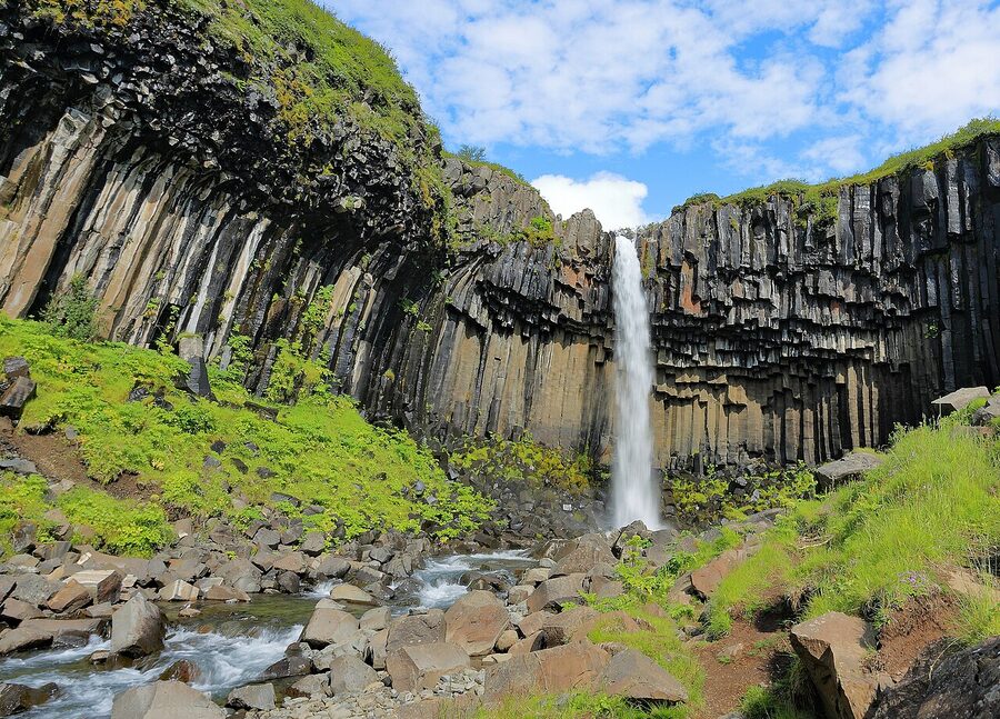
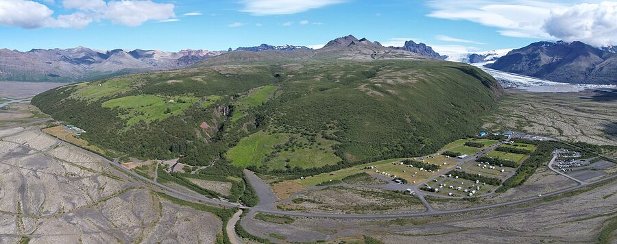
Skaftafell and Svartifoss
About 60 km east of Vík, the road delivers you to Skaftafell, the southern gateway to Vatnajökull National Park. The visitor centre has the only proper café for 70 km in either direction, clean toilets, and a parking fee of 1,000 ISK that goes to the park. There are ranger-led talks in summer.
The headline walk from the centre is up to Svartifoss, the “Black Falls.” It’s a 90-minute round trip on a wide, well-marked path that climbs about 150 metres through birch scrub. The waterfall itself isn’t huge, maybe 20 metres, but it pours over a cliff of basalt columns that the architect Guðjón Samúelsson studied when he was designing Hallgrímskirkja in Reykjavik. The shape of the cathedral’s facade is essentially Svartifoss.
If you’ve got more time, the longer Sjónarnípa loop adds another two hours and gives you a panoramic view down onto the Skaftafellsjökull glacier tongue. Skaftafell is also the launch point for guided glacier hikes onto Vatnajökull, Icelandic Mountain Guides has its sales hut right at the visitor centre car park, and there’s also Glacier Guides running tours from May through October. Hikes are around 13,000–18,000 ISK for three to four hours.
From November through March, the same operators run ice cave tours inside Vatnajökull. The caves form fresh every winter as meltwater carves new passages through the ice; no two seasons look the same. Around 22,000–28,000 ISK, includes the super-jeep ride out to the entrance.
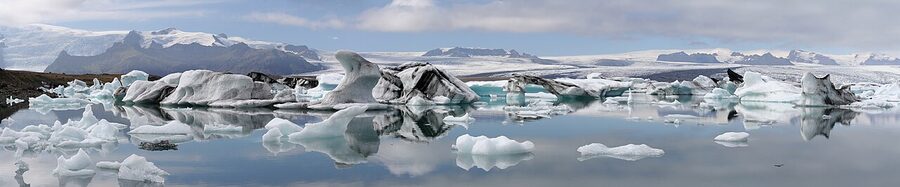
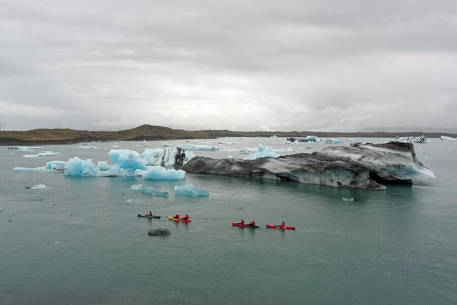
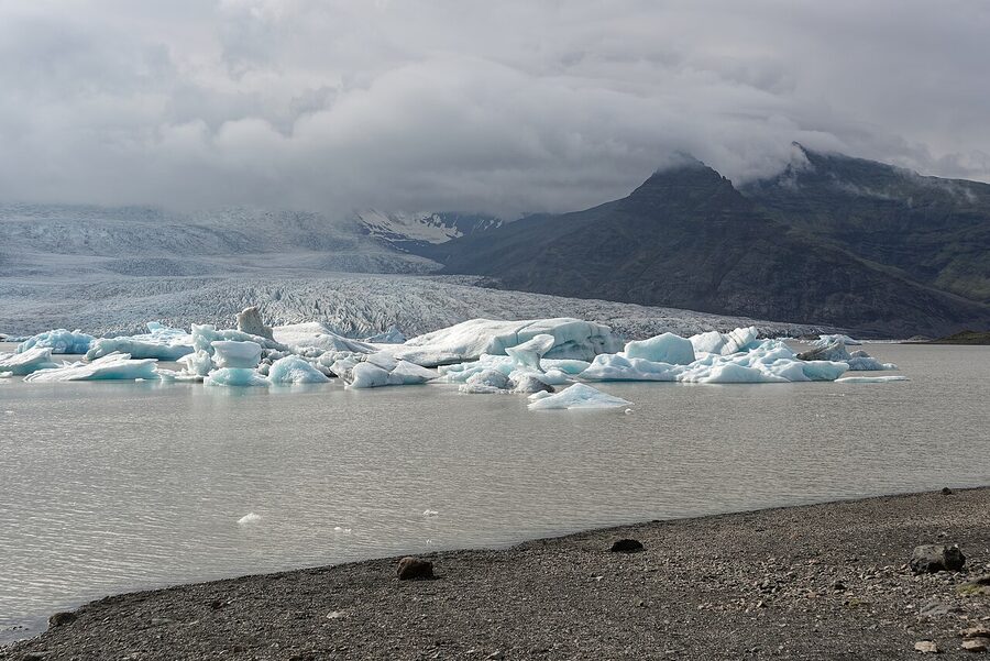
Jökulsárlón: the lagoon that keeps producing icebergs
Fifty kilometres east of Skaftafell, about an hour’s drive, Route 1 crosses a single-lane bridge over the most photographed body of water in Iceland. Jökulsárlón is a glacier lagoon, formed where the Breiðamerkurjökull glacier meets the sea and calves icebergs into a 25-square-kilometre lake. The lake didn’t exist before 1934. The glacier was in front of where you’re standing now. It’s been retreating since.
The icebergs sit in the lagoon, drift slowly toward a narrow outlet, and eventually flow out under the bridge into the North Atlantic. Some make it to the open sea. Others get pushed back onto Diamond Beach (next stop). The whole system turns over every couple of weeks; the lagoon you see today is not the lagoon you’d see in a fortnight.
It’s free to visit and stand at the edge. There’s a small café, toilets, and a parking area that fills up by 11am in summer. Get there before 9 or after 5 if you can. Look out for harbour seals, they fish in the outlet under the bridge most of the day, basking on the icebergs in summer.
Two boats run on the lagoon May through October. Amphibian boats hold about 30 people, last 40 minutes, around 11,500 ISK, they drive into the water from a ramp, the kids love them, you don’t really get up close to the ice. Zodiac boats take you in a 12-person inflatable, last 75 minutes, get within touching distance of the icebergs (you don’t actually touch them), around 17,000 ISK. Ice Lagoon and Arctic Adventures are the main zodiac operators. Minimum age 10 for zodiac (or 130 cm tall). Book the day before in summer; they sell out.
If you want to skip the queue at Jökulsárlón, drive five minutes back west to Fjallsárlón, a smaller glacier lagoon under a different tongue of Vatnajökull. Quieter, slightly cheaper boat tours (also zodiac), and you can usually walk up without booking. The icebergs are fewer but the setting is better, you see the actual glacier face plunging into the water, not just the calved ice.
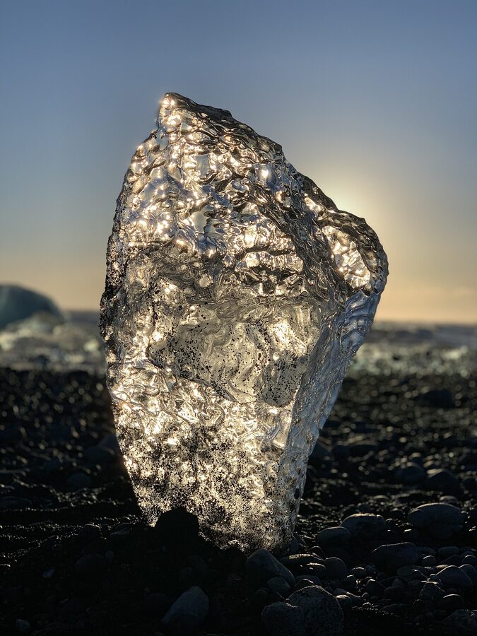
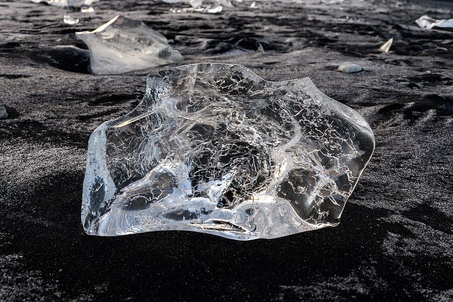
Diamond Beach: the icebergs come ashore
Across Route 1 from Jökulsárlón is Diamond Beach, the popular name for the stretch of black sand on the seaward side of the bridge where chunks of iceberg get washed back up. The contrast is what people come for: black volcanic sand, clear-as-glass ice, sometimes with the deep-blue cores still showing.
It’s free, it’s open all the time, and what’s on the beach changes every tide. Some days there’s enough ice to walk between car-sized blocks. Other days there’s hardly any, just a few fist-sized chunks. The wind off the sea is brutal in winter, gloves, hat, the warmest jacket you’ve got.
Same wave warning as Reynisfjara, though the danger is lower because the surf here isn’t as extreme. Still, don’t turn your back, don’t get too close to the waterline, don’t stand on icebergs that are floating in the surf zone (they roll, suddenly, with the tide).
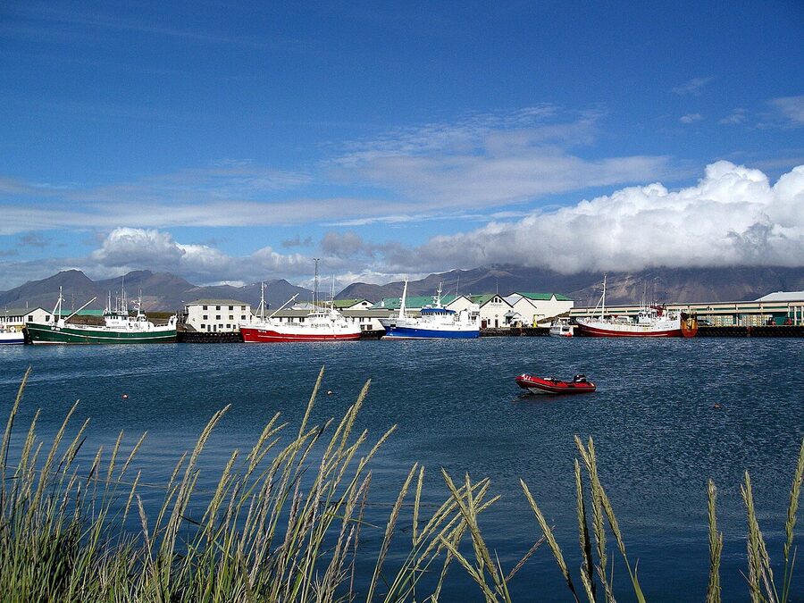
Höfn: langoustine, ice cap, end of the line
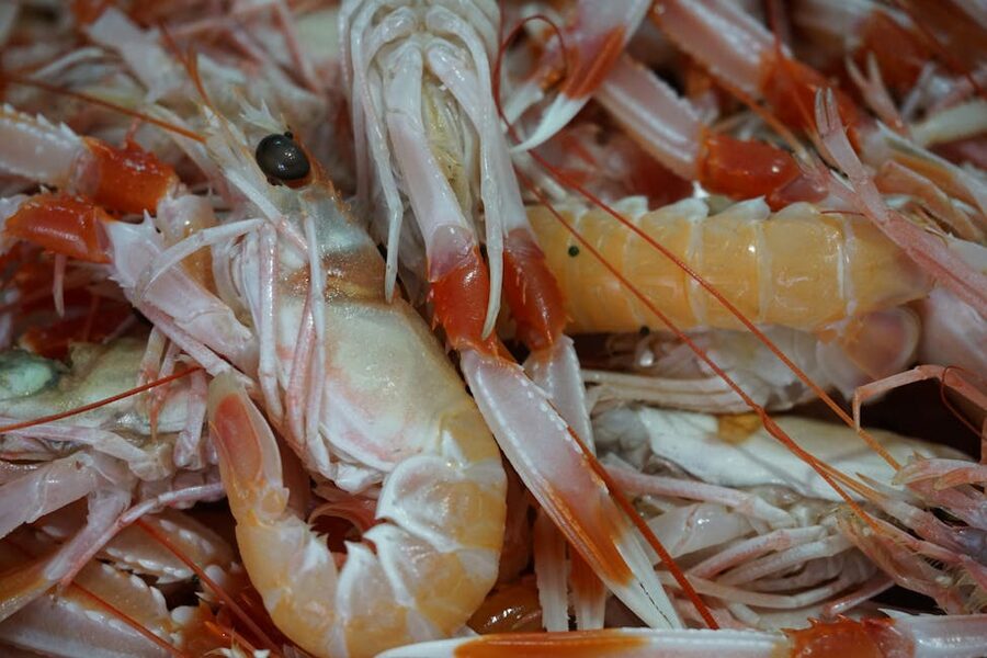
If you’re going all the way, Höfn í Hornafirði is your eastern end point, a small fishing town of about 2,400 people sitting on a thin spit of land between Vatnajökull and the Atlantic. The harbour is the only deep-water port between Reykjavik and the East Fjords, and what comes in off the boats is mostly langoustine. Höfn has built its reputation on it; there’s even a langoustine festival every June.
You came this far. Eat the langoustine. Two restaurants do it well: Pakkhús, in a converted warehouse on the harbour, does the classic grilled tail with garlic butter (around 7,500 ISK for a main, more for the langoustine soup that comes with the head meat included). Humarhöfnin across the harbour is the other contender; smaller, slightly cheaper, the langoustine pizza is a local favourite among people who don’t realise they’re not supposed to like the idea.
The drive east of Höfn into the East Fjords is one of the most underrated stretches in Iceland, quiet, dramatic, scattered with tiny fishing villages. But it’s a different trip. If you’ve come this far on a tight schedule, turn around at Höfn, drive back along the same Route 1, and try to get to Vík for sleep that night. The straight drive Höfn-Reykjavik is around 6 hours.
Where to sleep in Höfn: Fosshotel Glacier Lagoon sits halfway between Skaftafell and Höfn, big modern hotel, restaurant on site, around 45,000–70,000 ISK. Hotel Höfn is in town and walking distance to the restaurants, around 35,000–55,000 ISK. Hali Country Hotel is 55 km west, set under the glacier with a small museum about Þórbergur Þórðarson (one of Iceland’s stranger 20th-century writers, raised in this exact farmhouse), around 35,000–50,000 ISK.
Getting there: drive, bus, or guided tour
Self-drive
This is the version I’d choose. You set the pace, stop where you want, eat where you want, leave when you want. Renting a car in Iceland is straightforward, pick up at Keflavík airport or in Reykjavik, drop off at the same place. Route 1 is paved the whole way, two lanes, no F-roads. A small 2WD is fine in summer; in winter you want a 4WD with proper winter tyres (legally required from 1 November to 14 April).
Fuel is around 320 ISK per litre at time of writing. The N1 stations in Selfoss, Hella, Vík, Kirkjubæjarklaustur, and Höfn are your refuel stops, don’t drop below quarter tank in winter. Park-by-app is the norm at the busy waterfalls (Parka or EasyPark, both work in English).
Bus tours from Reykjavik
If you don’t want to drive, several operators run full-day South Coast bus tours from BSÍ terminal. Reykjavik Excursions has been doing it longest (since 1968), their classic South Shore Adventure runs daily year-round, 10–11 hours, around 15,000 ISK. Gray Line runs a similar tour, slightly larger buses, similar price. Bustravel and Iceland Horizon run small-group versions in 16-seat minibuses, around 22,000 ISK, more flexible at the stops.
For multi-stop bookings spanning glacier hikes, ice caves, or zodiac tours, the aggregator platforms tend to have the best deals, try GetYourGuide, Viator, or Klook for combo packages.
Multi-day organised trips
Iceland’s main packagers, Nordic Visitor, Hidden Iceland, Iceland Travel, all run 2-, 3-, and 4-day South Coast trips with hotels included. Useful if you don’t want to plan or drive. Expect 80,000–150,000 ISK per person per day for a mid-range trip including hotel, transport, and one or two activities.
For a fuller comparison of what’s available on a single day from the city, our day tours from Reykjavik guide goes through every option.
When to go
Summer (June to August)
Long days, mild temperatures (8–15°C), every road open, every operator running. The downside is crowds at the waterfalls and full hotels in Vík from mid-June through August. Daylight runs 20+ hours in late June; you can do the Reykjavik–Vík–Reykjavik day trip and still be back in the city before sunset. Best season for first-timers, families, anyone who doesn’t want to think about ice on the road.
Winter (November to March)
Shorter days (4 hours of light in December), cold, frequent storms, but the South Coast in snow is genuinely magnificent and you might catch the Northern Lights from anywhere east of Vík. This is also the only season for ice cave tours into Vatnajökull. Drive a 4WD with studded tyres, check road.is twice a day, and add buffer time for everything. If you’re doing this in winter, the 2-day version with a Vík overnight is much safer than trying to do it as a day trip.
Shoulder seasons (April–May, September–October)
The sweet spot for me. Most things are open, the crowds are thinner, prices are lower, the weather is unpredictable but workable. April still gets snow flurries, May gets puffins back at Dyrhólaey. September has the first dark nights for aurora, you can chase the lights without sitting up till 2am like in winter. October is the gamble; some years you get gold, others you get sideways rain for a fortnight straight.
For more detail on month-by-month conditions, see Iceland in March, September, and winter; the best time to visit guide pulls the trade-offs together.
Activities to add along the route
If a day or two of stops doesn’t feel like enough, the South Coast has more to offer if you’ve got time and budget.
Glacier hike on Sólheimajökull or Vatnajökull. Three to four hours, real crampons on real ice. About 13,000–18,000 ISK. The most accessible adventurous thing on the route, non-hikers can manage it.
Ice cave at Vatnajökull. November through March only. Around 22,000–28,000 ISK. The caves form fresh each winter from meltwater channels, see our ice cave guide for which operators to book through.
Snowmobile on Mýrdalsjökull from Vík. Run by Arctic Adventures and a few smaller operators, around 30,000–40,000 ISK for two hours including the super-jeep ride up. Year-round, weather permitting. Our snowmobile tour guide has the comparison.
Zodiac at Jökulsárlón. May to October, 75 minutes, around 17,000 ISK, get within touching distance of icebergs. Book a day in advance.
Photography tour. The South Coast is one of the most-shot stretches in Iceland for good reason. Specialist photo tours run by photo-tour operators add a guide who knows the light and the unmarked viewpoints, useful especially in winter for aurora and ice caves.
Northern Lights chase. If your trip is in aurora season (September–April), most South Coast hotels can arrange an evening lights chase with a guide who watches the cloud forecasts. Or self-drive somewhere dark east of Vík and check the Veður aurora forecast on your phone. Cleared sky and KP 3 or higher and you’re in business, but never promised, that’s the deal you make with the sky here.
What it costs
Rough numbers, in ISK, at time of writing. Prices in Iceland move with the krona; treat these as orders of magnitude.
Day trip from Reykjavik, self-drive: 12,000 ISK fuel + 1,600 ISK parking (Seljalandsfoss + Skaftafell), plus food. Maybe 18,000 ISK total per car for two adults if you bring a sandwich.
Day trip, bus tour: 15,000–22,000 ISK per person, lunch separate. The classic Reykjavik Excursions South Shore Adventure is around 15,000 ISK; small-group operators 20,000+.
Two days with Vík overnight, self-drive, mid-range: Hotel night around 40,000 ISK for two. Fuel 25,000 ISK across both days. Two dinners at Suður-Vík or similar 12,000 ISK. Add one activity (glacier hike at Sólheimajökull) 14,000 ISK per person. Total around 110,000 ISK for two people for the two days.
Three days to Höfn, mid-range: Two hotel nights around 80,000 ISK for two. Fuel 40,000 ISK across three days. Three dinners 18,000 ISK. Two activities (glacier hike + zodiac at Jökulsárlón) 30,000 ISK each. Total around 200,000 ISK for two for three days.
Compare against currency at the time you book, see our Iceland currency guide for cards, ATMs, and what to expect at the till.
What I’d actually do
Two days, self-drive, Vík overnight at Hotel Vík í Mýrdal. Out of Reykjavik by 8am Day 1. Lava Centre at Hvolsvöllur (skip if you’re tired). Seljalandsfoss + Gljúfrabúi at lunch, eat a sandwich in the car park. Skógafoss mid-afternoon (climb the steps if the sky is clear). Skip the plane wreck unless the kids have to see it. Quick stop at Dyrhólaey for the view. Reynisfjara from the safe upper area only, see it, don’t risk it. Check into Vík by 6pm. Dinner at Suður-Vík.
Day 2: out the door by 8am again, an hour east to Sólheimajökull for a 3-hour guided ice walk if you’ve booked one (worth it). Lunch at the Skaftafell visitor centre café. Walk up to Svartifoss in the afternoon (90 minutes round trip). Push on to Jökulsárlón for late afternoon, the light at the lagoon between 5 and 7pm in summer is the best you’ll see anywhere in the country. Walk across Route 1 to Diamond Beach for half an hour. Then the long drive back, about 4.5 hours to Reykjavik. Eat in the car. Don’t try to do it without two drivers if you can help it.
That itinerary will give you the South Coast in a way that the day trip simply cannot. You’ll have stood in front of three waterfalls, walked on a glacier, climbed to a fourth waterfall, watched icebergs calve into a lagoon they didn’t exist before 1934, and slept in a town that the next big eruption of Katla will probably destroy. It’s a lot of Iceland in 36 hours.
What to skip if you’re tight on time
Honest list of the stops I’d cut first if you’ve only got 8 hours and you’re trying to do a Reykjavik return.
- Sólheimasandur plane wreck. 8 km round-trip walk for a single photo of an old fuselage. Fine if you’ve got the time, brutal if you haven’t.
- Skógar Folk Museum indoor exhibits. The outdoor turf houses are free and tell the same story in 20 minutes.
- Bobby Fischer’s grave. Small detour, only worth it if you care about chess history.
- Hellisheiði power plant tour. The visitor centre is fine for 15 minutes; the full guided tour takes 90 you don’t have.
What I would not skip even with 8 hours: Seljalandsfoss + Gljúfrabúi together, Skógafoss (just the bottom), and a careful look at Reynisfjara from the high ground at Dyrhólaey. Those three give you the South Coast in compressed form.
One last thing about the weather
Þetta reddast is what we say here when something looks unworkable, it’ll work out. The South Coast tests that philosophy harder than most parts of Iceland. The wind comes off the open Atlantic with no land between here and Antarctica to slow it. Storms close Route 1 in winter without much notice. Sand storms in late summer can sandblast a rental car back to bare metal.
Two habits make it manageable. First, check vedur.is the night before and again at breakfast, they post road forecasts in plain English. Second, give yourself a buffer. If the schedule says 2 hours from Vík to Skaftafell, plan for 3. You’ll either arrive early or you’ll arrive on time despite the wind. Both are fine.
And if Reynisfjara is on red alert when you arrive, do not bargain with the sea. Drive on. The black sand will still be there next time. The waves do not care that you flew here from Singapore.
If you do nothing else outside Reykjavik, do this drive. Even the day-trip version is one of the great drives you can take in any country I’ve seen. The full version, all the way to Höfn, is the trip that makes people stop posting “Iceland was nice” and start phoning friends to say they’re going back.