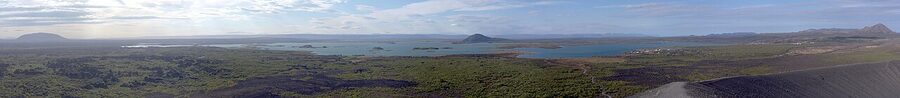
If you only see one place in north Iceland, it should be Mývatn. The name means Midge Lake, which is a fair warning for July and a bad piece of marketing the rest of the year. What it really is: a shallow blue lake in a flat green plain, ringed by old volcanic craters, surrounded by lava fields, smoking fumaroles, a milky-blue geothermal spa, and the kind of landscape that makes you understand why HBO sent the Game of Thrones crew here for the scenes north of the Wall. About an hour and a half east of Akureyri on Route 1, in a corner of the country most first-time visitors never reach.
I’ve sent friends to the south coast and watched them come back happy. I’ve sent friends to Mývatn for two days and watched them come back changed. There’s something about standing at Hverir at seven in the morning with the wind blowing sulphur steam across the parking lot, then driving fifteen minutes to soak in 38°C water at the new Earth Lagoon, that doesn’t happen anywhere else on the island.
This is the long version of how to do it properly. What’s there, what’s worth your time, what to skip, where to sleep, and how to fit the waterfalls and the canyons into one trip. If you’ve got two days from Akureyri you can do nearly all of it. One long day is possible but rough. Three days is luxury. Read on.
In This Article
- What Mývatn actually is
- Why it’s worth the drive
- The Earth Lagoon, what used to be Mývatn Nature Baths
- Hverir, the Mars landscape
- Krafla and the Víti crater
- Dimmuborgir, the dark castles
- Hverfjall, the perfect cone
- Grjótagjá and the cave Game of Thrones made famous
- Skútustaðagígar, the pseudocraters
- The lake itself: birds, ducks, and the midges
- Goðafoss, the waterfall of the gods
- Dettifoss, Europe’s most powerful waterfall
- Ásbyrgi, Odin’s hoofprint
- Húsavík and the whales, half a day north
- Where to stay in Mývatn
- Mývatn (Berjaya Iceland Hotels), formerly Hotel Reynihlíð
- Sel-Hotel Mývatn
- Fosshotel Mývatn
- Vogafjós Farm Resort
- Hotel Laxá
- Skútustaðir Farm Guesthouse
- Where to eat
- How to plan a Mývatn visit
- The long day from Akureyri (8 to 10 hours)
- The overnight (24 hours, my pick)
- Two nights, three days (the proper trip)
- Best season
- Game of Thrones in the Mývatn area
- Driving from Mývatn
- Tours from Akureyri or Reykjavik
- Practical bits
- What I’d actually do
- The bigger picture
What Mývatn actually is
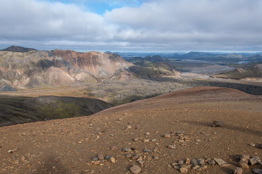
The lake itself is shallow, eutrophic, and 37 km² of mostly flat water. It formed about 2,300 years ago when a basaltic eruption near what’s now the Krafla system sent lava flowing across an old river valley, dammed it, and let the meltwater pond up behind. The lake fills the dam. The lava is everything you see around it. That’s the short version.
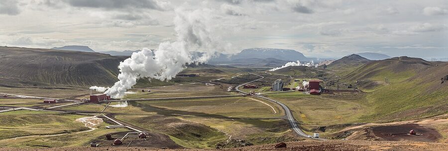
What the short version misses: this is one of the most active volcanic regions on the planet. The Krafla system just to the northeast went off in nine separate eruptions between 1975 and 1984, in something Icelandic geologists call the Krafla Fires. Steam still leaks out of the rifts. The geothermal plant on the next ridge produces 60 MW from boreholes drilled into the magma chamber. In 2009, scientists at the Iceland Deep Drilling Project accidentally drilled directly into molten rock at 900°C, around 2.1 km down. They had to cap the hole. It’s that kind of place.
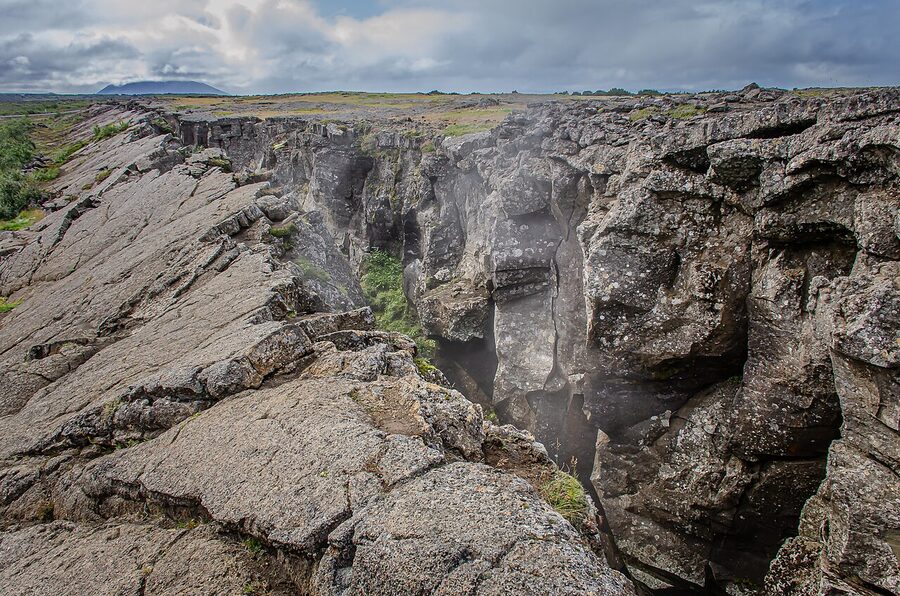
Lake Mývatn is also the only spot in Europe where you can stand on the actual ridge of the Mid-Atlantic Ridge and watch ducks fly past. The North American and Eurasian plates are pulling apart at about 2 cm a year right under your feet. You don’t feel it. The ducks don’t either. But it’s there.
Why it’s worth the drive
Most people who fly to Iceland do the Golden Circle, the south coast, and maybe Snæfellsnes. They never make it north. There are good reasons for that, mostly related to the time it takes to get up here. From Reykjavik, Mývatn is about 6.5 hours of driving in summer. From Akureyri it’s 90 minutes. So either you fly to Akureyri (Icelandair has multiple daily flights from Reykjavik domestic, around 45 minutes) or you do the Ring Road and Mývatn becomes day three or four of the loop.
Worth it for what, then. For the density. In a 30-minute radius from Reykjahlíð (the village on the lake’s east shore) you have: a geothermal spa, a perfect tephra cone you can climb in 25 minutes, an actively steaming sulphur field that looks like Mars, the most photographed lava castle in Iceland, a cave with a hot spring that was a Game of Thrones set, and a 12-metre waterfall on the way in. Within 90 minutes: Europe’s most powerful waterfall, a horseshoe canyon that Norse mythology says was made by Odin’s eight-legged horse, and the whale-watching capital of Iceland. There is no other Icelandic destination that packs this much into this small a circle.
And it’s quieter. Even in peak July, Hverir at 7am is still you, two camper vans, and a couple of Germans with tripods. The south coast is a Disney queue by comparison.
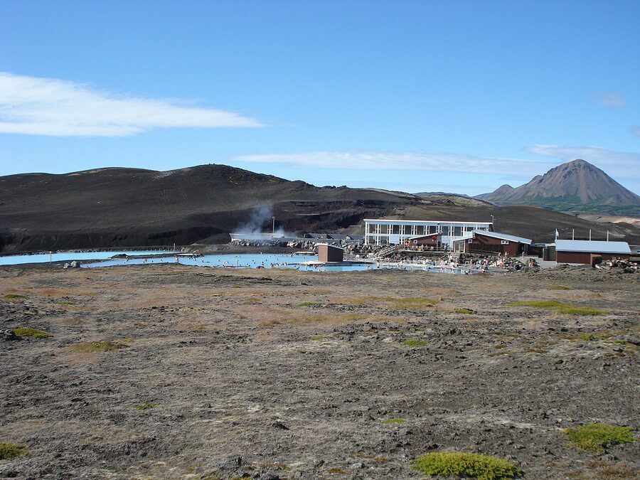
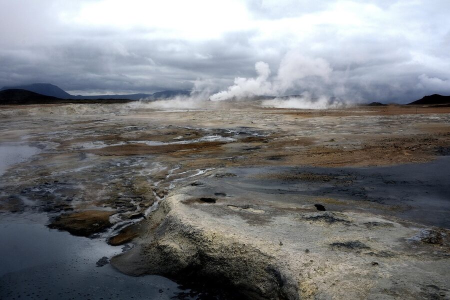
The Earth Lagoon, what used to be Mývatn Nature Baths
Quick note before anything else: as of spring 2026, what was for years called Mývatn Nature Baths (Jarðböðin við Mývatn) has reopened under a new name and a new building. It’s now Earth Lagoon Mývatn. Same site on the Námafjall ridge, same milky-blue geothermal water, but the old wooden facility is gone and a new 4,000 m² stone-clad building has replaced it. It opened in late March 2026 after about three months of construction. If you booked under the old name, your reservation is fine. The website is now earthlagoon.is.
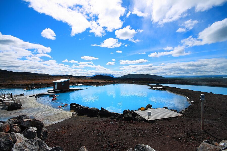
What’s it like to actually use. You park, walk into the new fissure-style entrance, pay (around 6,500 ISK at the old facility, expect a small bump for the new one), get a wristband, do the Icelandic shower-naked routine in the changing rooms, then step outside into the lagoon. The water is the colour of a Caribbean swimming pool, the air is around 5°C even in summer, and the steam hits your face like a wet towel. Walk to the far end where the water is hottest. Stay until your fingers prune. Get out, wrap up, drive ten minutes to dinner.
How it compares to the Blue Lagoon: the water chemistry is similar (silica, sulphur, mineral salts), the temperature is the same range, the views are arguably better. The Blue Lagoon has more facilities, a louder spa industry around it, and a price tag pushing 10,000 ISK before extras. Earth Lagoon is calmer, cheaper, and looks out over a lava field instead of a power plant. If you’re going to Mývatn, do this one. If you’re choosing between the two and you’re flying out of Keflavík, the Blue Lagoon is more convenient. Either way you don’t need both unless you’re a hot-springs completist. For more on the wider category see our guide to hot springs in Iceland.
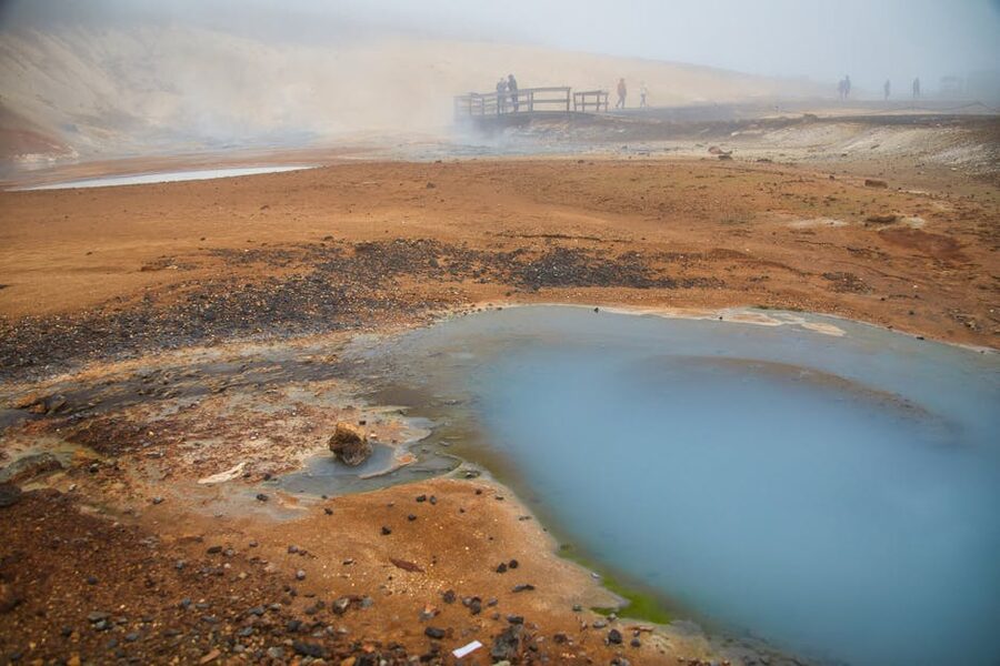
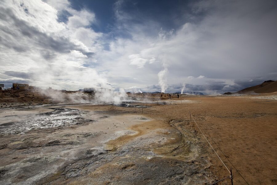
Hverir, the Mars landscape
Five minutes’ drive east of Earth Lagoon, on the other side of the Námafjall ridge, is Hverir. This is the geothermal area that gets photographed for every Iceland article and book cover. Boiling grey mud pots, ochre clay, hissing fumaroles, and the constant smell of rotten eggs.
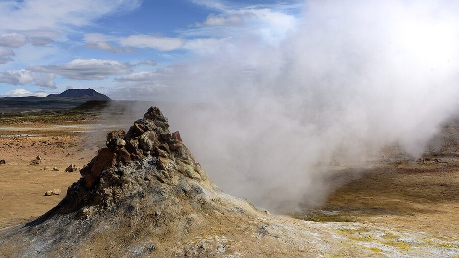
It’s free, it’s open 24 hours, and the parking lot is just off Route 1. Go early or go late. By 10am the tour buses arrive and the small loop walk gets congested. By 7pm they’ve left. The light at dawn is the best because the steam catches the low sun and the entire field looks like it’s smoking.
Practical: bring layers, wind here is constant. Don’t wear anything you mind smelling of sulphur for the rest of the day. Keep your eyes open for the small “boiling pot” right by the path that’s deeper than the others; it’s the loudest, and the most photogenic. There are no facilities, no toilets, no café. Use the Earth Lagoon’s facilities before or after.
If you cross the small ridge at the back of Hverir on foot (about 15 minutes up, marked path), you get views down into the Bjarnarflag valley with the geothermal power plant on one side and the lake on the other. Most people don’t bother with the ridge. It’s the better photo of the two.
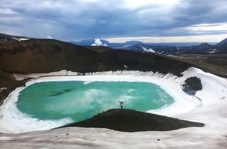
Krafla and the Víti crater
About 10 km north of Hverir, off Route 863, is the Krafla volcanic system. This is where the Krafla Fires happened from 1975 to 1984, and where Iceland built one of its first geothermal power plants. You drive past the plant (you can stop at the visitor centre, which is small and has free coffee), then continue up to the Víti crater parking.
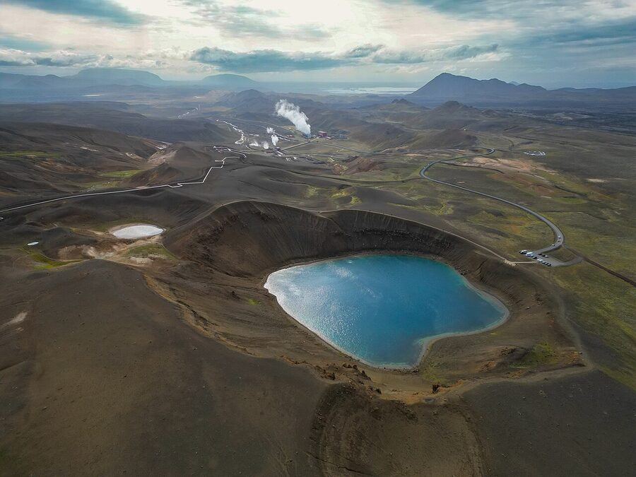
Víti is a maar, formed by a steam explosion in 1724. The lake at the bottom is around 7°C even in summer (don’t swim in it, despite the colour) and the rim walk gives you a perfect circle view of a volcano that could go again any day. Nobody minds. Iceland is used to this.
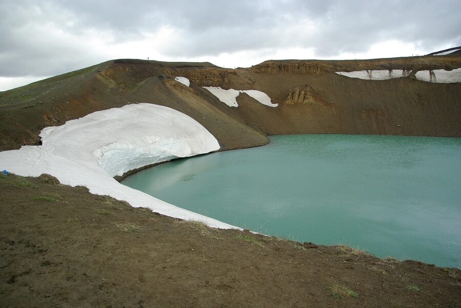
Beyond Víti, on the other side of the parking lot, is the Leirhnjúkur lava field. The black, still-warm-in-places lava here is from 1984. You can walk a 2 to 3 hour loop through it, and in places the ground is genuinely warm under your hand. Wear proper boots; the surface is sharp and uneven.
The geothermal plant itself is worth a slow drive past, even if you don’t stop. Sixty megawatts from a hole in the ground. The plant was built right on top of the caldera and survived the 1980s eruptions, which is its own kind of Icelandic story.
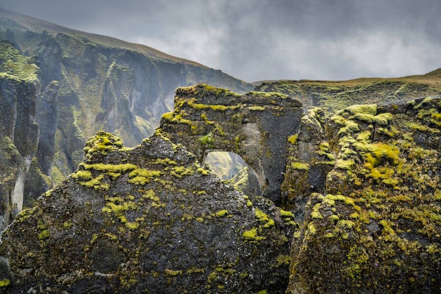
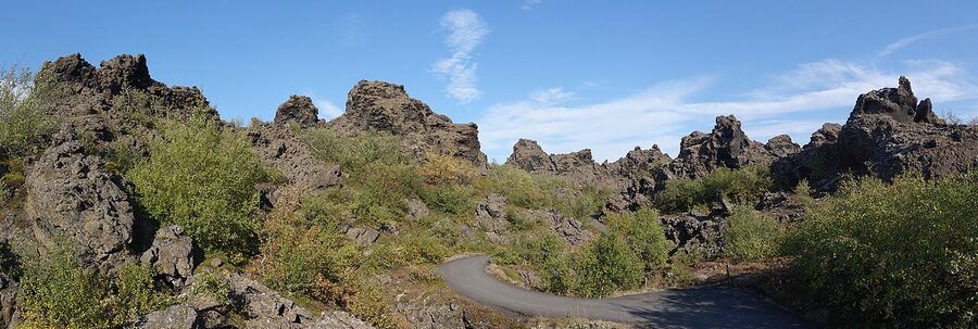
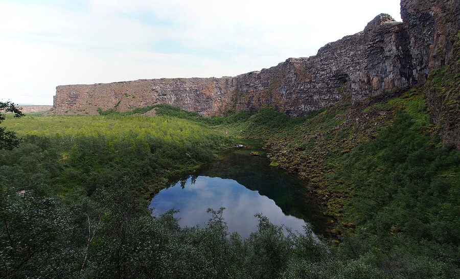
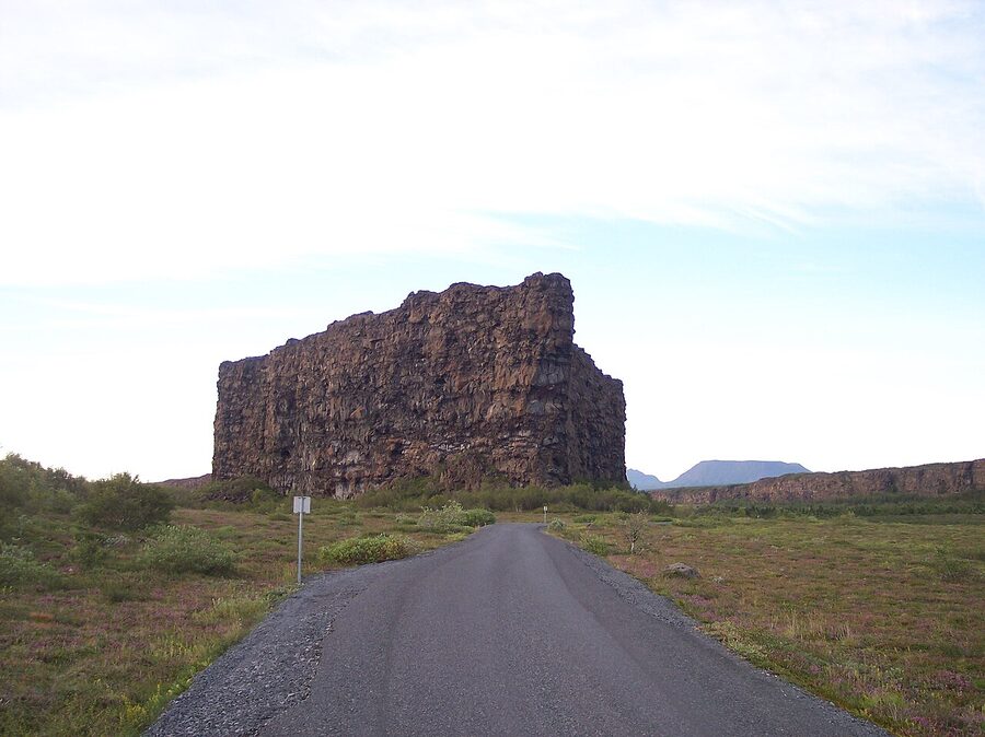
Dimmuborgir, the dark castles
Dimmuborgir means “Dark Castles” and that’s what it looks like: a 2 km² field of jagged lava pillars, arches, and hollow chimneys, some 20 metres tall. It formed when a lava lake drained suddenly and the cooling crust collapsed in on itself. There’s nothing like it in Europe. The closest geological cousins are in the Mexican deserts, and even those are smaller.
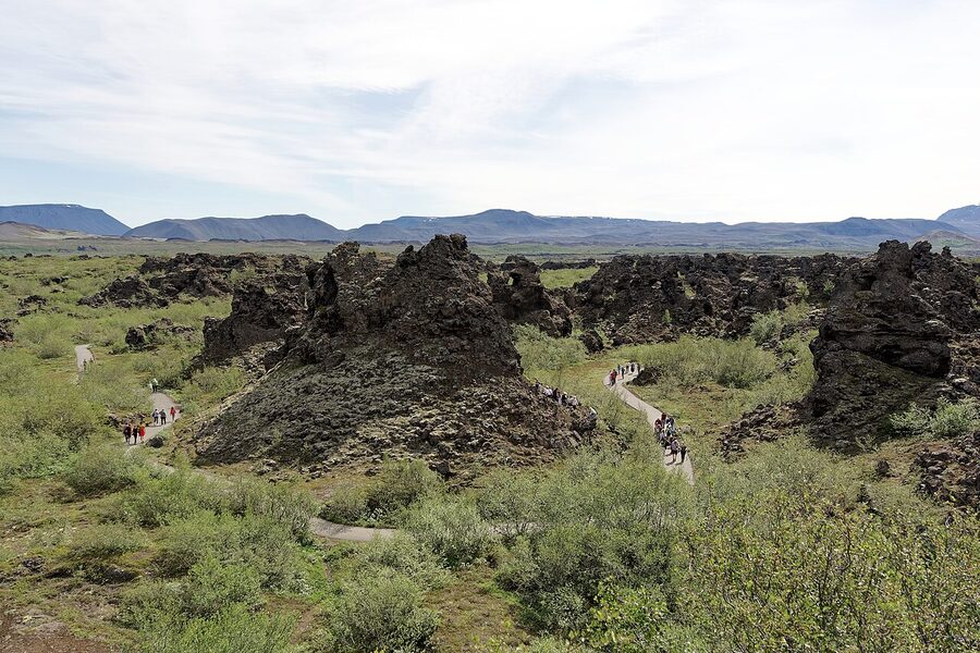
Three trails: the Small Circle (30 minutes, paved, good for kids and anyone with knees), the Church Loop (45 minutes, takes in Kirkjan, the famous “church” arch), and the Krókastígur trail (90 minutes, circles the whole area). I’d do the Church Loop on a first visit. The arch itself is worth the trip and the trail past it goes through the densest part of the formations.
In Icelandic folklore, Dimmuborgir is where the Yule Lads live. There are thirteen of them, the sons of the troll-woman Grýla, and they come down to town one at a time in the thirteen days before Christmas. We covered them in detail in our Christmas in Iceland piece. If you visit Dimmuborgir in late December (a) you’re brave because the road is often closed, and (b) there’s usually a costumed Yule Lad somewhere in the formations for kids.
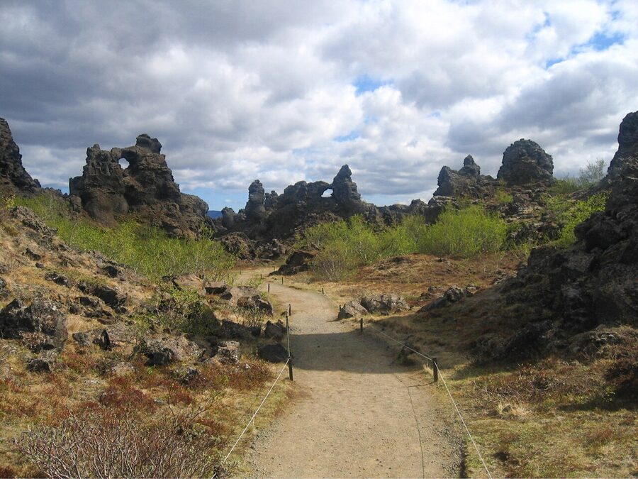
Dimmuborgir was also a Game of Thrones location. The Wildling camp where Mance Rayder negotiates with Jon Snow in Season 3 was filmed inside the formations. There’s no plaque, no signage, no fan tour. Most Icelanders prefer it that way.
Practical: there’s a small café and toilet block at the entrance. Free parking. Open year-round but the trails are icy from November to April; bring microspikes if you’re visiting in winter (we wrote a whole piece on what to pack, see the Iceland packing list).
Hverfjall, the perfect cone
Just south of Dimmuborgir, looming over the lake’s east shore, is Hverfjall (sometimes called Hverfell on older maps). It’s a tephra cone, almost geometrically perfect, 1 km across at the rim and 140 m deep at the bottom. It formed in a single explosive eruption about 2,500 years ago, then never erupted again.
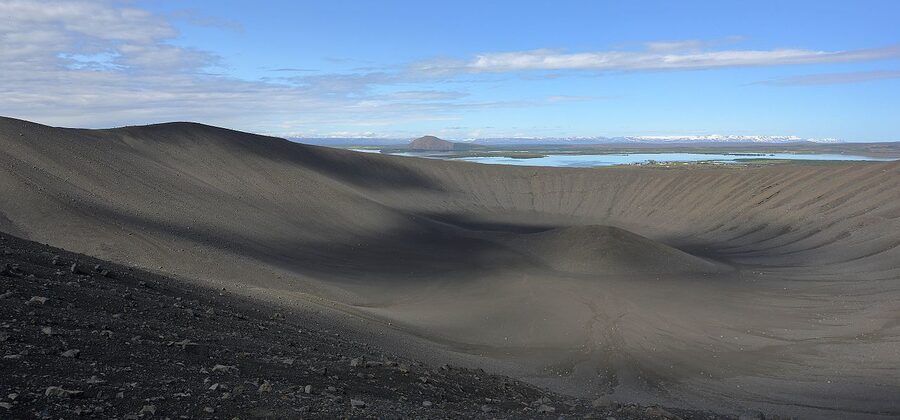
The hike up is steeper than it looks but short. From the top, the view is the entire lake, Dimmuborgir, the Krafla ridge in the distance, and on a clear day, the snow-capped Vindbelgjarfjall on the far western shore. Wind on the rim is brutal even on calm days at lake level. Take a hat.
Park at the south parking (Route 860). The north access from Reykjahlíð is technically illegal due to erosion concerns; locals would rather you didn’t.
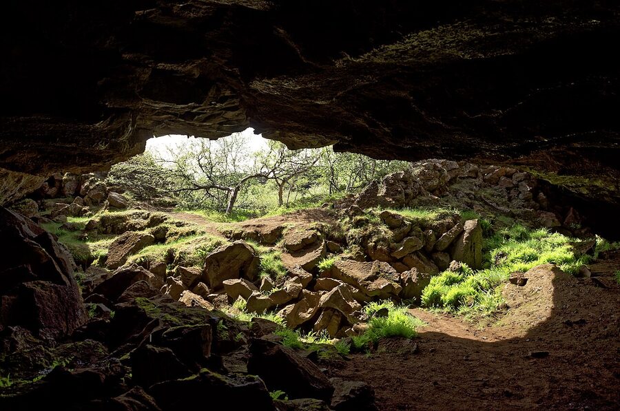
Grjótagjá and the cave Game of Thrones made famous
Grjótagjá is a small lava cave with a hot spring in it. From the late 19th century until the 1970s, it was a popular bathing spot for locals. Then the Krafla Fires heated the water past 50°C (uncomfortable to dangerous), and bathing was banned. The water has since cooled to around 43 to 46°C, which is warm enough to be technically swimmable, but the cave itself is now closed to bathing on the owner’s land. You can look in. You cannot get in the water.
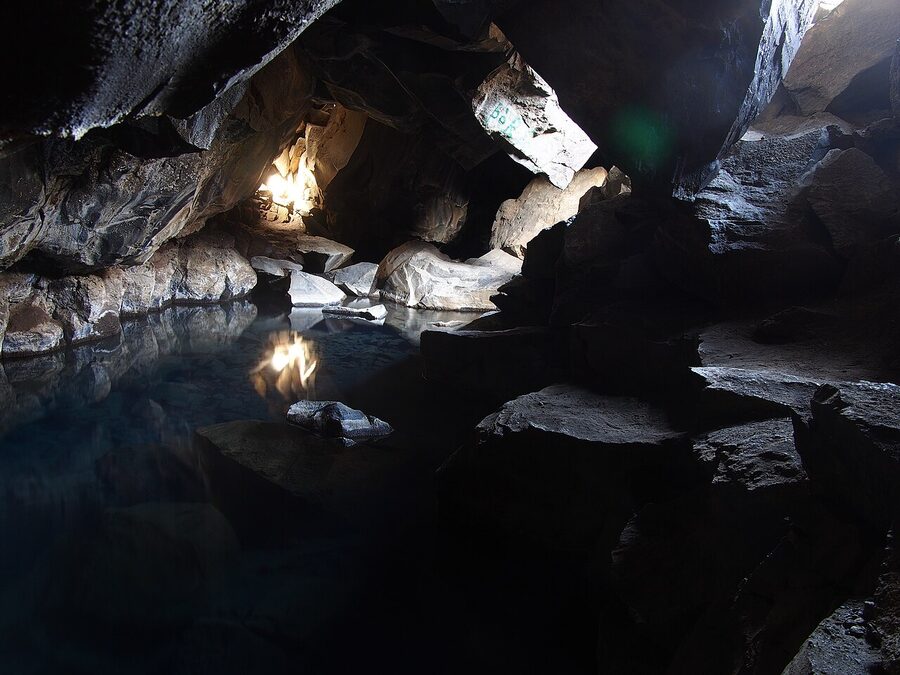
This is the cave from Game of Thrones Season 3, where Jon Snow breaks his vows with Ygritte. The actual swimming was filmed in a studio (the cave was tighter than the camera needed) but the establishing shots are real. There’s no signage, no admission, no queue. You drive up Route 860 to a small parking, walk five minutes through lava across an open field, and step down into a fissure barely wider than your shoulders. The whole visit takes 15 minutes.
If you want to actually bathe in something natural here, the small Stóragjá fissure a kilometre down the road has a smaller pool you can technically get into, though the access is awkward and the water is quite warm. Most people just go to the Earth Lagoon. It’s easier and the water is cleaner.
Skútustaðagígar, the pseudocraters
On the south shore of the lake at Skútustaðir is a cluster of pseudocraters: small crater-like mounds that look like tiny volcanoes but aren’t. They formed when the lava that created the lake flowed over wet ground; the water flashed to steam, blew out through the lava as it cooled, and left these miniature ring craters behind.
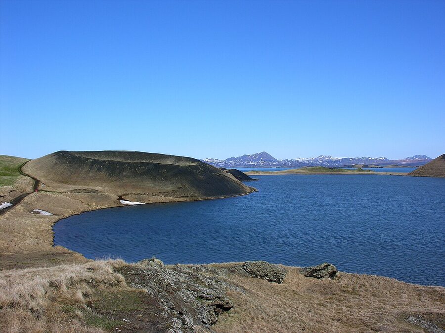
There are walking paths around them, free, family-friendly. It’s not a bucket-list stop on its own, but if you’re doing the lake loop drive (Route 1 + Route 848 around the south and west shore) it takes 45 minutes and you get the photo. Skútustaðagígar is also one of the better birdwatching spots in the area, especially in May and June when migratory ducks pass through.
The lake itself: birds, ducks, and the midges
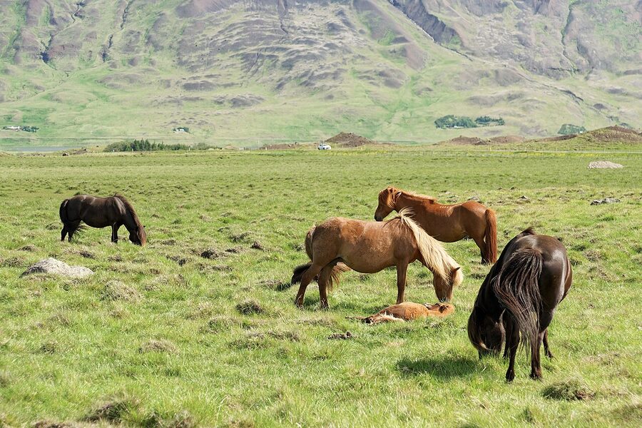
Mývatn is one of the most important breeding lakes in Europe. Fifteen species of duck nest here every summer, including Barrow’s goldeneye, harlequin duck, and the long-tailed duck, which is genuinely rare. If you’re a birder this is a major destination on its own. There’s a bird museum at Sigurgeir’s farm on the lake’s north shore that’s worth an hour if it’s raining.
For the rest of us: the midges. The lake is named after them. Mý means midge, vatn means lake, and from late May through August there are clouds of them in the air every still summer evening. The good news is most species don’t bite. The bad news is they fly into your eyes, ears, and mouth. The fix is a head net: 1,500 ISK at any petrol station in the area, looks ridiculous, works perfectly. Wind disperses them, so windy days are fine. Sunny still evenings are the worst. We covered the seasonal logistics in Iceland in summer.
The biting species (mostly black flies) are present too, just less numerous. They’re worse at the river mouths than at the lake itself. If you’re sensitive, keep moving.
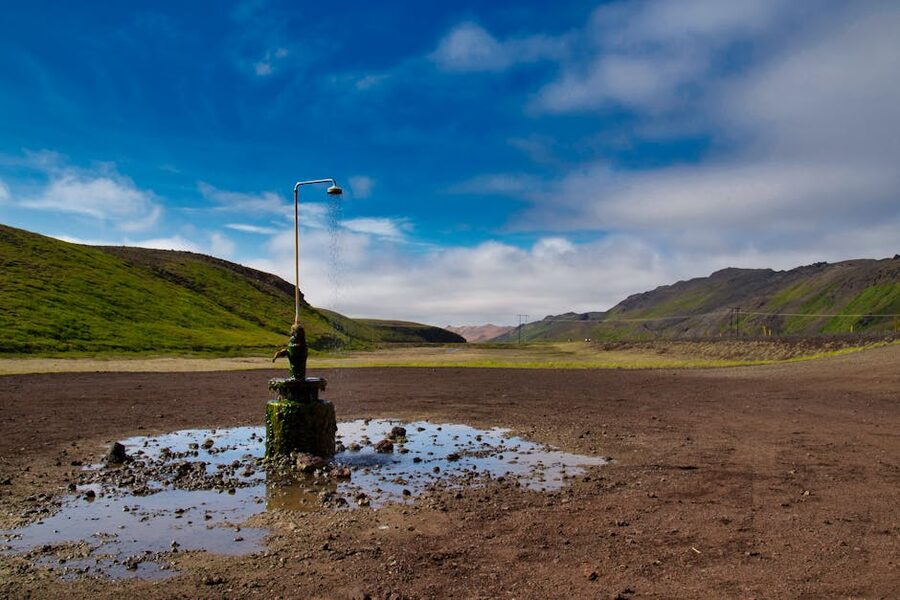
You can fish for trout in the lake (permits required, ask at any guesthouse) and you can take the loop drive around it in about an hour with stops. There are no boat rentals on the lake itself; the breeding ducks need quiet, so the lake is paddle-only and even that is restricted in nesting season.
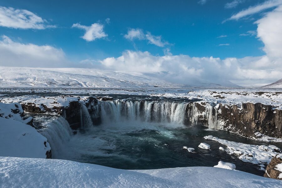
Goðafoss, the waterfall of the gods
Thirty minutes west of Mývatn on Route 1, on the way back to Akureyri, is Goðafoss. It’s a 12-metre horseshoe waterfall, 30 metres wide, and it’s one of the most photographed in Iceland for good reason: the river splits in two over a basalt ledge in a perfectly symmetrical curve.
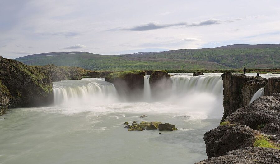
The name means “Waterfall of the Gods” and refers to the year 1000 AD, when Iceland decided in a single Alþingi assembly to convert from Norse paganism to Christianity. Þorgeir, the lawspeaker, returned home to his farm at Ljósavatn (just east of here), took his wooden statues of the old gods, and threw them into the falls. The story is in Ari Þorgilsson’s Íslendingabók, written about 130 years after the event, so take it with the salt that any 12th-century history deserves. But the falls have been called Goðafoss ever since.
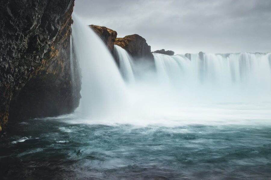
Practical: free, year-round. Both banks have parking and viewing platforms. The east bank gets the morning sun on the falls. The west bank has the better long view. Both are accessible in 5 minutes from the car. There’s a small souvenir shop and toilets at the east bank parking lot, and a hotel (Fosshótel Goðafoss, separate from the Mývatn one) if you want to stay overnight here.
If you’re driving from Akureyri, Goðafoss is the natural first stop on the way to Mývatn (35 minutes east of Akureyri). On the way back, it’s the natural last stop before dinner. Either direction works.
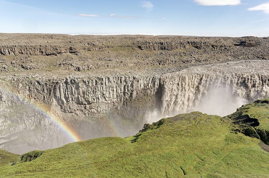
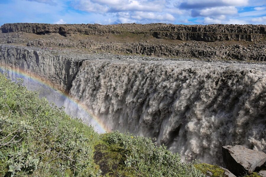
Dettifoss, Europe’s most powerful waterfall
An hour east of Mývatn off Route 862 is Dettifoss. This is the big one. 100 metres wide, 44 metres tall, average flow 193 m³ per second, and at peak meltwater closer to 500. It’s not the highest waterfall in Europe, not the widest, not the prettiest. It is the most powerful by sheer volume. In person it’s the kind of thing where the noise reaches you before the view does.
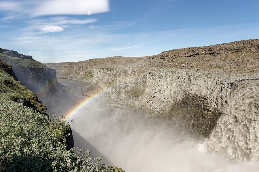
There are two banks. The west bank (Route 862) is paved all the way from the Ring Road, has a proper parking lot, toilets, and a 1 km walk to the falls on a graded path. The view is the wide front of the falls and the canyon spreading out below. The east bank (Route 864) is partly gravel and the road is closed in winter. The east-bank view gets you closer to the lip and is more dramatic if you have the time and the right vehicle. For most people, on a one-day visit, the west bank is the right answer.
Dettifoss made a brief Hollywood appearance in the opening scene of Ridley Scott’s Prometheus. The pale humanoid drinks from a goblet and dissolves into the river. That’s the falls. They look slightly more inviting in real life.
About 1 km upstream of Dettifoss is Selfoss, a smaller, much wider waterfall (about 11 m tall and over 100 m wide) that most people miss because they walk straight back to the parking after Dettifoss. Don’t. The walk between the two takes 15 minutes each way and Selfoss is photogenic in a different way: lower, wider, more like a series of curtains than a single drop.
Practical season: the west bank is open year-round but icy from November through April; bring spikes. The east bank closes around mid-October and reopens in June, depending on snow. Check road.is the morning of your trip.
Ásbyrgi, Odin’s hoofprint
Another hour north from Dettifoss, where the Jökulsá á Fjöllum river meets the coast, is Ásbyrgi. It’s a horseshoe-shaped canyon, 3.5 km long and 1.1 km wide, with cliffs 100 metres high on three sides. The floor is covered in birch and willow forest, which in Iceland is unusual enough to feel exotic. Norse myth says the canyon is the hoofprint of Sleipnir, Odin’s eight-legged horse, when he stumbled and his foot touched down. Geology says it was carved by an enormous glacial flood about 8,000 years ago, when a sub-glacial lake on Vatnajökull burst and sent half the ice cap’s meltwater roaring down to the sea in a few days.
In the middle of the canyon is Eyjan, “the island”, a flat-topped rock formation that splits the horseshoe into two arms. You can walk to the back wall in about 45 minutes from the visitor centre, and there are short trails that climb up to the rim if you want a view down. The visitor centre at Gljúfrastofa has a small exhibit on the geology and the local birdlife (gyrfalcon, golden plover) and serves coffee.
If you have a full day, you can hike from Ásbyrgi to Dettifoss (and back, with a car shuttle) on the Jökulsárgljúfur trail through the canyon. It’s a serious 34 km, two days with a tent. Most visitors do a 2 to 3 hour loop within Ásbyrgi itself and call it.
This whole stretch (Ásbyrgi, Dettifoss, Mývatn, and Húsavík) is marketed as the Diamond Circle, North Iceland’s answer to the Golden Circle. It’s a real loop of about 250 km from Húsavík and back. We’ll mention this again under route planning.
Húsavík and the whales, half a day north
An hour and a quarter north of Mývatn on Route 87 is Húsavík, the whale-watching capital of Iceland. It deserves its own day on a longer trip and we wrote a full guide to it: Húsavík Whale Watching. Short version: Skjálfandi Bay is shallow, food-rich, and one of the most reliable places in Europe to see humpbacks at close range. Multiple operators run from the harbour. Three hours on the water, around 12,000 ISK, May through October.
If you’ve got two full days, a Húsavík morning is the easiest add-on. Drive up after breakfast at Vogafjós, do a 9am whale tour, eat fish at the harbour, drive back via Goðafoss to Akureyri or back to Mývatn for a second night. If you’re doing a 3-day Mývatn trip, fold Húsavík in on day two and Dettifoss + Ásbyrgi on day three.
Where to stay in Mývatn
The lake has maybe a dozen places to stay between the village of Reykjahlíð on the east shore and Skútustaðir on the south. Demand massively outstrips supply in July and August, so book early or you’ll be commuting from Akureyri.
Mývatn (Berjaya Iceland Hotels), formerly Hotel Reynihlíð
The biggest hotel on the lake, in the village of Reykjahlíð. It used to be Hotel Reynihlíð and then Icelandair Hotel Mývatn; it’s now operated by Berjaya Iceland Hotels. Comfortable rooms, decent restaurant, walking distance to the church and the lake shore, parking. This is the easy default if you want a proper hotel and don’t care about character. Check rates on Booking.com.
Sel-Hotel Mývatn
On the south shore at Skútustaðir, family-run, slightly old-school but in a nice way. Closer to the pseudocraters, slightly further from the geothermal sights. The restaurant is decent. Good for couples who want quiet. Check rates on Booking.com.
Fosshotel Mývatn
The newest big hotel, opened in 2017. Modern wood-and-glass building on the east shore with proper lake views from most rooms. Bigger and more anonymous than Sel-Hotel but the views are the best on the lake. Check rates on Booking.com.
Vogafjós Farm Resort
A working dairy farm with a guesthouse and restaurant attached, on the east shore between the village and Dimmuborgir. The restaurant (the Cowshed Café) is one of the best places to eat in the area; the rooms are simple and the cows are 20 metres away. If you want a real Iceland-farmstay experience, this is it. Check rates on Booking.com.
Hotel Laxá
South of the lake at the Laxá river, modern, glass-fronted, designed to disappear into the landscape. Quiet, slightly remote, good for couples and photographers. A 15-minute drive to the lake itself. Check rates on Booking.com.
Skútustaðir Farm Guesthouse
Old farm guesthouse on the south shore right by the pseudocraters. Smaller and cheaper than the hotels, family-run, basic but clean. Good for hikers and bird people. Check rates on Booking.com.
Where to eat
Three places worth knowing:
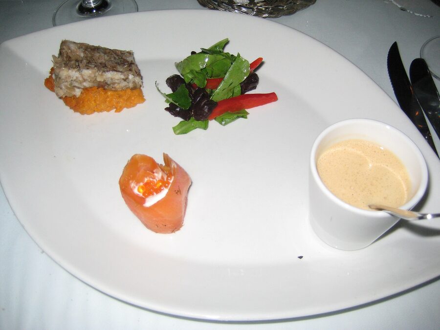
Vogafjós Farm Restaurant (the Cowshed Café) on the east shore is the local pick. You can watch the cows being milked through a window from your table. The menu is short and farm-driven (smoked lamb, fresh trout from the lake, geyser bread baked in the geothermal ground at the back of the property). It’s not cheap, but it’s the most distinctly Mývatn place to eat. Reservations recommended in summer.
Daddi’s Pizza in Reykjahlíð is the local institution for everyone who isn’t doing fine dining. Wood-fired, decent toppings, fast service, open late. After Hverir or the Earth Lagoon when you’re tired and don’t want to think, this is the answer.
Gamli Bærinn, attached to the Mývatn Berjaya hotel in Reykjahlíð, is the catch-all pub menu (burgers, fish soup, lamb stew). Reliable, busy in summer, fine.
For a proper sit-down with a wine list, the restaurant at Fosshotel does the best plate in the area, in my opinion. Vogafjós for character and the local angle. Daddi’s for everything else.
How to plan a Mývatn visit
Here are the three plans I’d actually recommend, depending on how much time you’ve got.
The long day from Akureyri (8 to 10 hours)
Possible but a bit miserable. Leave Akureyri at 8am, stop at Goðafoss for 30 minutes, push on to Hverir for a quick walk, do the Earth Lagoon for a 90-minute soak, drive the lake loop in your car (Skútustaðagígar, Dimmuborgir), and head back to Akureyri for dinner. You’re skipping Krafla, Dettifoss, and Ásbyrgi. You’re skipping the morning light at Hverir and the evening light at the lake. You’ll be tired. Do this only if you genuinely have one day.
The overnight (24 hours, my pick)
Drive from Akureyri after lunch on day one. Goðafoss on the way (30 min). Arrive Mývatn around 4pm. Earth Lagoon for the late afternoon soak. Dinner at Vogafjós. Sleep at Sel-Hotel or Fosshotel. Day two: up early, Hverir at 7am before the buses, then Krafla and Víti, then Dimmuborgir mid-morning, then Hverfjall climb, then Skútustaðagígar on the south shore on the way back. Late lunch, drive back to Akureyri via Goðafoss again if you want a different angle. This is the right amount of time for the Mývatn area itself.
Two nights, three days (the proper trip)
Same first day as above. Day two: up early to Hverir, then Krafla and Víti before lunch. Lunch at Daddi’s. Afternoon to Húsavík for a 4pm whale tour (book ahead). Back to Mývatn for sunset and the Earth Lagoon a second time, if you can be bothered. Dinner at Vogafjós or back at the hotel. Day three: leave early for Dettifoss (1 hour east, west bank parking, walk to Dettifoss and Selfoss together, 90 minutes total). Continue to Ásbyrgi (another hour north), do a 2-hour loop. Then drive back to Akureyri the long way through Húsavík and over the Tjörnes peninsula (3 hours) for the scenery, or back via Mývatn and Goðafoss for speed.
This is the plan if you’ve come specifically to see north Iceland. Anything less and you’re rushing.
Best season
Mývatn is open year-round but most of what makes it special is easier in summer.
June through August is high season. All roads open, all sights accessible, midges in their full glory, midnight sun (the sun barely sets in late June; you can hike Hverfjall at 11pm). Hotels expensive and full. Book everything weeks ahead.
September and early October are the sweet spot, in my view. Roads still mostly open, midges gone, autumn colour in the birch around Ásbyrgi, prices coming down, aurora season starting. We covered this in detail in Iceland in September.
Late October through April is winter. The Earth Lagoon is magical in winter, especially with northern lights overhead. Dimmuborgir under snow is otherworldly. But the east-bank Dettifoss road is closed, the Krafla road is sometimes closed, Hverfjall is icy. Everything takes longer. This is a stunning trip if you have the patience for the conditions; check our Iceland in winter guide for the planning side.
May is the spring shoulder. Roads mostly open by mid-month, ducks arriving, snow still capping the higher ground. Lovely if you’re flexible about weather.
Game of Thrones in the Mývatn area
Three filming locations worth knowing if you care:
Dimmuborgir for the Wildling camp scenes in Season 3, where Mance Rayder’s army is camped beyond the Wall. The dark vertical pillars stand in nicely for the kind of jagged frozen edge of the world they were trying to convey.
Grjótagjá cave for the famous Jon Snow + Ygritte scene. As mentioned, the actual hot-spring shots were done in a studio because the cave is too small for film equipment. The exterior fissure shots are real.
Höfði, a small forested headland on the lake’s east shore, was used for some of the frozen-lake battle scenes in Season 5 (Hardhome, mostly shot elsewhere, but parts were filmed here). It’s a 20-minute walk through birch trees with views back across the lake. Free to visit, parking off Route 1.
None of these are signposted or commercialised, which is part of the charm. Iceland generally doesn’t make a big deal of its film locations.
Driving from Mývatn
To Akureyri: 90 minutes via Route 1, paved all the way, easy in any car.
To Reykjavik: 6.5 hours via Route 1 in summer. In winter it’s a serious drive and check road conditions before leaving. See our Ring Road piece for the full loop logic.
To Húsavík: 1 hour 15 minutes via Route 87 (faster, scenic) or Route 85 (longer, via the coast).
To Dettifoss west bank: 1 hour via Route 862, paved.
To Ásbyrgi: 1 hour 45 minutes via Route 862 then Route 85.
The lake loop itself (around the lake on Route 1 + Route 848) is about 36 km and takes an hour in driving alone, plus stops. Very flat, easy.
Petrol: there’s an N1 station in Reykjahlíð. Fill up here before heading to Krafla or Dettifoss. There’s nothing for 60 km in either direction.
Roads: in summer, all the main routes are paved. The east-bank Dettifoss road (Route 864) is gravel and rough. Anything marked F (F88, F-road into the highlands towards Askja) is restricted to 4×4 only and closed most of the year. We covered F-road logic in the Iceland highlands guide.
Tours from Akureyri or Reykjavik
If you’re not driving, you have options. Multiple operators run day tours from Akureyri to the Mývatn area, usually a long 10 to 12 hour day covering Goðafoss, Hverir, Krafla, the Earth Lagoon, and Dimmuborgir.
Saga Travel (sagatravel.is), based in Akureyri, runs the most consistent Mývatn tours, including small-group versions and shore-excursion variants for cruise ships. They’re the operator I’d default to.
SBA-Norðurleið runs the bigger coach tours, including the daily Reykjavik Excursions feeders. Less personal but reliable.
Multi-day packages including the Diamond Circle from Reykjavik are available through Nordic Visitor, Iceland Travel, and others, usually a 5 to 7 day itinerary covering the whole north. See the booking platforms GetYourGuide Iceland and Viator Iceland for current options.
For photography-focused tours of the area, see our photography tours of Iceland. The light at Hverir and Dettifoss is genuinely worth the dedicated trip.
Practical bits
Mobile coverage: 4G works in Reykjahlíð and along Route 1. It drops out around Krafla, around Dettifoss, and on the Tjörnes peninsula. Don’t rely on it for navigation; download offline maps before you go.
Money: cards everywhere, including the small visitor centres. You don’t need cash. We covered this in detail in Iceland’s currency.
Weather: wind is the issue at Hverir, Hverfjall, and the lake shore. Snow is the issue from October to May. Always check vedur.is the morning of your trip and road.is for road status. Safetravel.is for general weather warnings.
Toilets: at Earth Lagoon, at the Dimmuborgir café, at the Goðafoss east-bank parking, at the Dettifoss west-bank parking, at the Ásbyrgi visitor centre. Hverir, Krafla, Hverfjall: nothing.
Midge nets: N1 in Reykjahlíð, around 1,500 ISK. Worth it from late May through August.
Aurora: Mývatn is well placed for aurora viewing in the dark months (late September through mid-April). Low light pollution, open horizons, high latitude. Check the aurora forecast guide for how to plan around it. The Earth Lagoon at night, in winter, with KP 4 or higher, is a near-perfect Iceland evening.
What I’d actually do
Two days from Akureyri. Drive across after lunch, Goðafoss on the way, settle in to Sel-Hotel Mývatn before dinner. Earth Lagoon for the late soak, the new fissure entrance done properly with the steam-room cave they’ve built. Dinner at Vogafjós, the smoked lamb plate and the geyser bread, sit by the cow window if it’s free. Bed.
Day two up at 6am for Hverir before the buses. Coffee from the thermos in the parking lot while the sun comes up over the ridge. Then drive 20 minutes north to Krafla, walk the Víti rim, walk into the Leirhnjúkur lava field for an hour. Lunch from Daddi’s pizza taken to a bench by the lake. Hverfjall climb after lunch, all the way around the rim, an hour to 90 minutes total. Dimmuborgir late afternoon when the light comes in low through the formations. Quick stop at Skútustaðagígar on the way out. Drive back to Akureyri via Goðafoss for the evening light on the falls.
That’s the trip. You’ve covered the volcanic stuff, the lake, the Earth Lagoon, the two best waterfalls within reach, and you’ve eaten well. Skip Dettifoss and Ásbyrgi only if you have to; if you can squeeze a third day in, do them on the way back to the Ring Road.
The bigger picture
Mývatn is the part of Iceland that most first-time visitors don’t see. The Golden Circle is famous because it’s close to Reykjavik. The south coast is famous because it’s pretty and accessible. Mývatn is famous in Iceland because it’s the most concentrated piece of weird volcanic landscape on the island. A new geothermal spa, a horseshoe waterfall with a Christianisation legend, an actively steaming sulphur field, a perfect tephra cone you can climb in 25 minutes, a fake-castle lava field that doubled as the Wildling camp on TV, Europe’s most powerful waterfall, a horseshoe canyon supposedly hoof-printed by a Norse god, and the whale-watching capital of Iceland, all within 90 minutes of one base.
If you’ve been to Iceland once and you’re planning a second trip, this is where you go. If it’s your first trip and you have eight days or more, fly into Reykjavik, do the Golden Circle and the south coast, then fly to Akureyri and spend two nights at Mývatn before flying home from Reykjavik. The flight is an hour and the change in landscape is total.
Þetta reddast. Most things in Iceland do. But Mývatn rewards the kind of trip that gives it space to breathe. Two days is the right amount of time. Three is better. One is a near-miss. Plan accordingly.